
eBook - ePub
Reducing Disaster Risk by Managing Urban Land Use
Guidance Notes for Planners
This is a test
Compartir libro
- 112 páginas
- English
- ePUB (apto para móviles)
- Disponible en iOS y Android
eBook - ePub
Reducing Disaster Risk by Managing Urban Land Use
Guidance Notes for Planners
Detalles del libro
Vista previa del libro
Índice
Citas
Información del libro
This publication provides guidance for urban planners on how to use land use management-related tools they have at their disposal---land use planning, development control instruments, greenfield development, and urban redevelopment---to reduce disaster risk and contribute to strengthening urban resilience and sustainable urban development. The guidance provided in the document is further illustrated through case studies showing examples where urban land use management-related tools have been adopted to reduce disaster risk. It is hoped that this publication will support urban planners as a professional group to step up and embrace disaster risk reduction.
Preguntas frecuentes
¿Cómo cancelo mi suscripción?
¿Cómo descargo los libros?
Por el momento, todos nuestros libros ePub adaptables a dispositivos móviles se pueden descargar a través de la aplicación. La mayor parte de nuestros PDF también se puede descargar y ya estamos trabajando para que el resto también sea descargable. Obtén más información aquí.
¿En qué se diferencian los planes de precios?
Ambos planes te permiten acceder por completo a la biblioteca y a todas las funciones de Perlego. Las únicas diferencias son el precio y el período de suscripción: con el plan anual ahorrarás en torno a un 30 % en comparación con 12 meses de un plan mensual.
¿Qué es Perlego?
Somos un servicio de suscripción de libros de texto en línea que te permite acceder a toda una biblioteca en línea por menos de lo que cuesta un libro al mes. Con más de un millón de libros sobre más de 1000 categorías, ¡tenemos todo lo que necesitas! Obtén más información aquí.
¿Perlego ofrece la función de texto a voz?
Busca el símbolo de lectura en voz alta en tu próximo libro para ver si puedes escucharlo. La herramienta de lectura en voz alta lee el texto en voz alta por ti, resaltando el texto a medida que se lee. Puedes pausarla, acelerarla y ralentizarla. Obtén más información aquí.
¿Es Reducing Disaster Risk by Managing Urban Land Use un PDF/ePUB en línea?
Sí, puedes acceder a Reducing Disaster Risk by Managing Urban Land Use de en formato PDF o ePUB, así como a otros libros populares de Social Sciences y Global Development Studies. Tenemos más de un millón de libros disponibles en nuestro catálogo para que explores.
Información
Categoría
Social SciencesCategoría
Global Development Studies
PHOTO: ADB
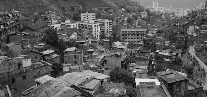
PHOTO: ADB
GUIDANCE NOTE 1: UNDERSTANDING DISASTER RISK
This note provides urban planners with guidance on how disaster risk assessment is undertaken: identifying hazards and understanding their characteristics, assessing the exposure and vulnerability of assets, and assessing disaster risk. While it is not the task of the urban planners to undertake such assessments by themselves, it is important for them to have a good understanding of what constitutes disaster risk; the process of assessing disaster risk; and, most importantly, how the results of the assessment can be used in the context of urban land use management.
KEY MESSAGES
Disaster risk is a function of probability of occurrence of hazards p(h), vulnerability v, and exposure e. It is expressed using the following formula:
Disaster risk = f(p(hi),v,e)
• Hazard characterizes the features of likely hazards, such as floods, earthquakes, tropical cyclones, or landslides, in a specific location in terms of frequency, intensity, and spatial occurrence, as well as their interlap.
• Vulnerability is a measure of the fragility of the assets at risk (physical characteristics and/or socioeconomic conditions) and how they perform given the intensity of hazard impact (whereby intensity includes attributes such as magnitude and duration).
• Exposure identifies the elements at risk in a specific location, such as size, composition, and density of the population, buildings, infrastructure, their cultural significance, and economic activity that could potentially be affected by the hazards.
Figure 1.1 shows a schematic diagram of examples of disaster risk in an urban setting.
Figure 1.1: Components of Disaster Risk in an Urban Setting
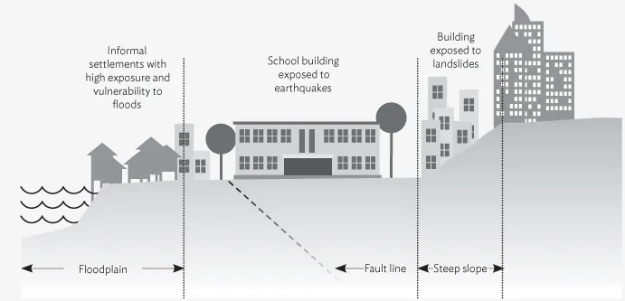
Source: Authors.
Understanding the spatial correlation between the multihazard landscape, on the one hand, and the vulnerability and exposure of the population, buildings, and infrastructure, on the other, will help urban planners undertake urban land use management-related decisions that will (i) reduce disaster risk in urban areas in the present and (ii) not increase urban disaster risk in the future. For example, an understanding of the characteristics of flooding in and around a city encourages the adoption of a land use policy that steers new development away from floodplains, restricts the use of wetlands and unstable slopes through development control regulations, prioritizes investments such as flood embankments, and informs stormwater drainage planning for the city.
KEY ACTIONS
For the successful application of disaster risk assessment in urban land use management:

LIKELY CHALLENGES
Uncertainties are inherent to disaster risk assessment, especially when modeling changes in the magnitude and intensity of extreme weather events, assessing flood risk, or assessing the impact of extreme and sudden events like large earthquakes. It is important to appreciate that uncertainties exists and discuss the implication for the results and decision making.
Data required for developing exposure database for the urban area and for undertaking vulnerability assessments may not always be available.
The public release of the disaster risk assessment outcomes can have significant effects on land and properties values. Thus, it is important to engage decision makers from the onset and use reputed national and/or local technical agencies (with inputs from international experts, where required) to demonstrate the credibility of the assessment results.
1.1 INTRODUCTION
Disaster risk can be characterized as a function of (i) the probability of occurrence of hazards of varying severity in a particular location, (ii) the people and physical assets that are situated in the location and exposed to the hazards, and (iii) the level of vulnerability of those people and assets to hazards.1,2
For example, in an earthquake-prone urban area, disaster risk is a function of many factors including (i) the probability of ground shaking, slope failure, liquefaction, up- or downthrust, and seiching induced by an earthquake occurrence; (ii) the population, housing, infrastructure, and cultural and economic activity located in the area and thus exposed to the physical effects of the earthquake; and (iii) the level of vulnerability due to the physical characteristics of buildings and infrastructure (e.g., the vulnerability of a residential building is a factor of building height, layout, proximity to other structures, age of the building, choice of construction material, and standard of construction) as well as other socioeconomic conditions (poverty level, livelihood choices, gender equity, land tenure security, etc.) of the population.
In other words, it is not just the hazard level, but equally what is at risk (the exposure) and why (the vulnerability of population and assets), which in turn is largely dependent on development processes which drive the level of disaster impact. This is particularly true for urban areas. Each hazard type the city is exposed to—geophysical, hydrological, meteorological, and climatological (as well as biological and technological)—has its own risk-creating characteristics that produce spatial variations in vulnerability and exposure.
For an urban planner working on urban growth and development, it is critical, for the following reasons, to understand the spatial correlation between the evolving multihazard landscape and the elements (population, buildings, infrastructure, and businesses) that are/will be at risk:
This requires assessing disaster risk and utilizing the findings of the assessment in decision making regarding urban land use management.
1.2 GETTING STARTED
In order to apply disaster risk assessment in urban land use management: