
eBook - ePub
Reducing Disaster Risk by Managing Urban Land Use
Guidance Notes for Planners
This is a test
Partager le livre
- 112 pages
- English
- ePUB (adapté aux mobiles)
- Disponible sur iOS et Android
eBook - ePub
Reducing Disaster Risk by Managing Urban Land Use
Guidance Notes for Planners
Détails du livre
Aperçu du livre
Table des matières
Citations
À propos de ce livre
This publication provides guidance for urban planners on how to use land use management-related tools they have at their disposal---land use planning, development control instruments, greenfield development, and urban redevelopment---to reduce disaster risk and contribute to strengthening urban resilience and sustainable urban development. The guidance provided in the document is further illustrated through case studies showing examples where urban land use management-related tools have been adopted to reduce disaster risk. It is hoped that this publication will support urban planners as a professional group to step up and embrace disaster risk reduction.
Foire aux questions
Comment puis-je résilier mon abonnement ?
Il vous suffit de vous rendre dans la section compte dans paramètres et de cliquer sur « Résilier l’abonnement ». C’est aussi simple que cela ! Une fois que vous aurez résilié votre abonnement, il restera actif pour le reste de la période pour laquelle vous avez payé. Découvrez-en plus ici.
Puis-je / comment puis-je télécharger des livres ?
Pour le moment, tous nos livres en format ePub adaptés aux mobiles peuvent être téléchargés via l’application. La plupart de nos PDF sont également disponibles en téléchargement et les autres seront téléchargeables très prochainement. Découvrez-en plus ici.
Quelle est la différence entre les formules tarifaires ?
Les deux abonnements vous donnent un accès complet à la bibliothèque et à toutes les fonctionnalités de Perlego. Les seules différences sont les tarifs ainsi que la période d’abonnement : avec l’abonnement annuel, vous économiserez environ 30 % par rapport à 12 mois d’abonnement mensuel.
Qu’est-ce que Perlego ?
Nous sommes un service d’abonnement à des ouvrages universitaires en ligne, où vous pouvez accéder à toute une bibliothèque pour un prix inférieur à celui d’un seul livre par mois. Avec plus d’un million de livres sur plus de 1 000 sujets, nous avons ce qu’il vous faut ! Découvrez-en plus ici.
Prenez-vous en charge la synthèse vocale ?
Recherchez le symbole Écouter sur votre prochain livre pour voir si vous pouvez l’écouter. L’outil Écouter lit le texte à haute voix pour vous, en surlignant le passage qui est en cours de lecture. Vous pouvez le mettre sur pause, l’accélérer ou le ralentir. Découvrez-en plus ici.
Est-ce que Reducing Disaster Risk by Managing Urban Land Use est un PDF/ePUB en ligne ?
Oui, vous pouvez accéder à Reducing Disaster Risk by Managing Urban Land Use par en format PDF et/ou ePUB ainsi qu’à d’autres livres populaires dans Social Sciences et Global Development Studies. Nous disposons de plus d’un million d’ouvrages à découvrir dans notre catalogue.
Informations
Sujet
Social SciencesSous-sujet
Global Development Studies
PHOTO: ADB
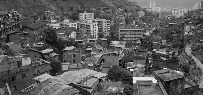
PHOTO: ADB
GUIDANCE NOTE 1: UNDERSTANDING DISASTER RISK
This note provides urban planners with guidance on how disaster risk assessment is undertaken: identifying hazards and understanding their characteristics, assessing the exposure and vulnerability of assets, and assessing disaster risk. While it is not the task of the urban planners to undertake such assessments by themselves, it is important for them to have a good understanding of what constitutes disaster risk; the process of assessing disaster risk; and, most importantly, how the results of the assessment can be used in the context of urban land use management.
KEY MESSAGES
Disaster risk is a function of probability of occurrence of hazards p(h), vulnerability v, and exposure e. It is expressed using the following formula:
Disaster risk = f(p(hi),v,e)
• Hazard characterizes the features of likely hazards, such as floods, earthquakes, tropical cyclones, or landslides, in a specific location in terms of frequency, intensity, and spatial occurrence, as well as their interlap.
• Vulnerability is a measure of the fragility of the assets at risk (physical characteristics and/or socioeconomic conditions) and how they perform given the intensity of hazard impact (whereby intensity includes attributes such as magnitude and duration).
• Exposure identifies the elements at risk in a specific location, such as size, composition, and density of the population, buildings, infrastructure, their cultural significance, and economic activity that could potentially be affected by the hazards.
Figure 1.1 shows a schematic diagram of examples of disaster risk in an urban setting.
Figure 1.1: Components of Disaster Risk in an Urban Setting
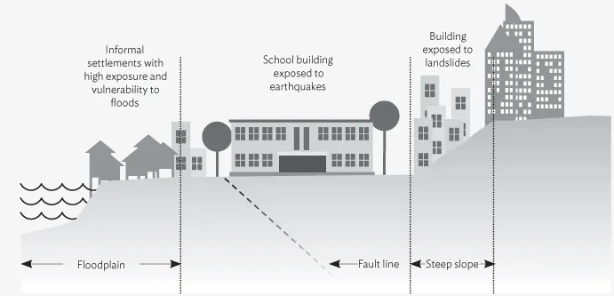
Source: Authors.
Understanding the spatial correlation between the multihazard landscape, on the one hand, and the vulnerability and exposure of the population, buildings, and infrastructure, on the other, will help urban planners undertake urban land use management-related decisions that will (i) reduce disaster risk in urban areas in the present and (ii) not increase urban disaster risk in the future. For example, an understanding of the characteristics of flooding in and around a city encourages the adoption of a land use policy that steers new development away from floodplains, restricts the use of wetlands and unstable slopes through development control regulations, prioritizes investments such as flood embankments, and informs stormwater drainage planning for the city.
KEY ACTIONS
For the successful application of disaster risk assessment in urban land use management:

LIKELY CHALLENGES
Uncertainties are inherent to disaster risk assessment, especially when modeling changes in the magnitude and intensity of extreme weather events, assessing flood risk, or assessing the impact of extreme and sudden events like large earthquakes. It is important to appreciate that uncertainties exists and discuss the implication for the results and decision making.
Data required for developing exposure database for the urban area and for undertaking vulnerability assessments may not always be available.
The public release of the disaster risk assessment outcomes can have significant effects on land and properties values. Thus, it is important to engage decision makers from the onset and use reputed national and/or local technical agencies (with inputs from international experts, where required) to demonstrate the credibility of the assessment results.
1.1 INTRODUCTION
Disaster risk can be characterized as a function of (i) the probability of occurrence of hazards of varying severity in a particular location, (ii) the people and physical assets that are situated in the location and exposed to the hazards, and (iii) the level of vulnerability of those people and assets to hazards.1,2
For example, in an earthquake-prone urban area, disaster risk is a function of many factors including (i) the probability of ground shaking, slope failure, liquefaction, up- or downthrust, and seiching induced by an earthquake occurrence; (ii) the population, housing, infrastructure, and cultural and economic activity located in the area and thus exposed to the physical effects of the earthquake; and (iii) the level of vulnerability due to the physical characteristics of buildings and infrastructure (e.g., the vulnerability of a residential building is a factor of building height, layout, proximity to other structures, age of the building, choice of construction material, and standard of construction) as well as other socioeconomic conditions (poverty level, livelihood choices, gender equity, land tenure security, etc.) of the population.
In other words, it is not just the hazard level, but equally what is at risk (the exposure) and why (the vulnerability of population and assets), which in turn is largely dependent on development processes which drive the level of disaster impact. This is particularly true for urban areas. Each hazard type the city is exposed to—geophysical, hydrological, meteorological, and climatological (as well as biological and technological)—has its own risk-creating characteristics that produce spatial variations in vulnerability and exposure.
For an urban planner working on urban growth and development, it is critical, for the following reasons, to understand the spatial correlation between the evolving multihazard landscape and the elements (population, buildings, infrastructure, and businesses) that are/will be at risk:
This requires assessing disaster risk and utilizing the findings of the assessment in decision making regarding urban land use management.
1.2 GETTING STARTED
In order to apply disaster risk assessment in urban land use management: