![]()
1Inland waterway transport
An overview
Rob Konings and Bart Wiegmans
1.1Introduction
Transport on waterways is the oldest means of inland transportation and has been the only serious mode of transport for a very long time. In former times, roads barely existed and their quality was bad because they were not paved, but rather were made of sand and clay and railroads did not exist at all. Transport on waterways offered both for passengers and goods the best transport options. Initially inland waterway transport could only take place on natural rivers making use of wind as propulsion. Later canals were dug and for these waterways vessels were introduced that used a horse or man for propulsion. The gradual development of the road network was a first step in the development of road transport as a serious transport mode, but this transport system had to wait for its breakthrough until after the introduction of the combustion engine. Before that the emergence of railroads in the early nineteenth century led to the first real competitor for inland waterway transport. The technological developments in road and rail transport together with network developments paved the way for large improvements in the performances of these modes (in terms of speed and costs) and hence created complete new competitive conditions between road, rail and inland waterway transport. Since the last decades of the twentieth century the overall trend in Europe has seen an increase in road transport and a decrease in both rail and inland waterway transport. In other more developed economies around the world a more or less similar trend can be noticed. However, it is undisputed that the development and use of inland waterways for the transport of goods is still of utmost importance as part of our total freight transport system. Furthermore, inland waterways perform a number of non-transport-related functions that also have significant economic and societal value. Waterway transport differs in this respect from other transport modes, which do not have these additional functions.
First, waterways have an important function in water management. Canals and rivers are widely used to supply water. This may be water for drinking, but is often for industrial purposes (i.e. cooling) or agricultural uses (i.e. irrigation), with the water being returned to the canal or river after use. Waterways are also used to transfer water between one part of the country and another, effectively acting as a pipeline. In addition, canals and rivers have functions in land drainage (Inland Navigation Commission, 2005).
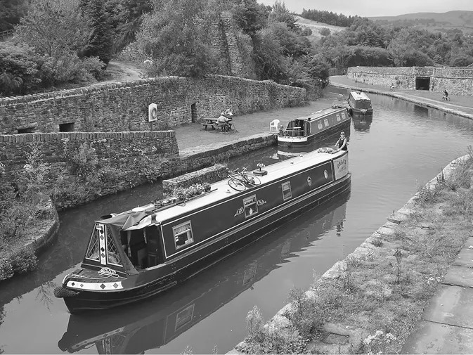
Second, waterways also have a touristic and recreational value. Many people like to spend their leisure time on activities related to waterways, e.g. swimming, sailing, fishing and walking or cycling alongside waterways. Moreover, people also value the existence of waterways as part of cultural heritage for their historical infrastructure, for the settlements along the waterways (e.g. historical villages, old industrial buildings) and for their environmental and landscape values (Inland Navigation Commission, 2005). A good illustration of this historical value of waterways is found in England and Wales. The extensive network of small canals that was built centuries ago for freight transport lost its transport function, but is now extremely popular among tourists (see Figure 1.1).
In this chapter we elaborate on the transport function of inland waterways. The aim of this chapter is to give a broad overview of inland waterway transport as a mode of transportation and to serve as a general introduction to the following chapters of this book. It is of course not possible to cover all aspects of a transport mode here and particularly not since the characteristics of the inland waterway transport sector differ widely across the world. The chapter will touch on some of these typical geographical differences, describe the role and position of inland waterway transport in the total freight transport system and looks into the societal value of inland waterway transport.
1.2Waterways: a precondition for inland waterway transport
The presence of waterways (rivers and canals) is together with their navigability an important precondition for inland waterway transport (IWT). Throughout the world there are over 600,000 km of navigable waterway networks (CIA, 2010). More than 50 countries have a navigable waterway network of more than 1,000 km in length, but in the majority of these networks IWT is underdeveloped (BVB et al., 2009). The largest networks are located in China, Russia and Brazil (see Table 1.1).
Table 1.1Total length of navigable waterways by country
| Country | Navigable length: km | Global share: % |
| China | 110,000 | 18 |
| Russia | 102,000 | 16 |
| Brazil | 50,000 | 8 |
| USA | 41,009 | 7 |
| Indonesia | 21,579 | 3 |
| Colombia | 18,000 | 3 |
| Vietnam | 17,702 | 3 |
| DR Congo | 15,000 | 2 |
| India | 14,500 | 2 |
| Burma | 12,800 | 2 |
| Argentina | 11,000 | 2 |
| Papua New Guinea | 11,000 | 2 |
| Bolivia | 10,000 | 2 |
| Peru | 8,808 | 1 |
| Nigeria | 8,600 | 1 |
| France | 8,501 | 1 |
| Bangladesh | 8,370 | 1 |
| Finland | 7,842 | 1 |
| Germany | 7,467 | 1 |
| Malaysia | 7,200 | 1 |
| Others | 131,269 | 21 |
| Total world | 622,647 | 100 |
| Total Europe | 52,332 | 8 |
China’s network covers today more than 110,000 km of navigable waterways accounting for 5,600 different waterways (EICB, n.d.). However, only 50 per cent of these can accommodate vessels of about 50 m length; and only 6.5 per cent can take vessels that exceed 1,000 tonne capacity. All in all, the commercially significant waterways total 24,000 km (Amos et al., 2009). The three longest rivers are the Yangtze (6,378 km), connecting the mid and southwest of China with the seaport of Shanghai, the Pearl river, a major hinterland axis between Hong Kong and southeast China, and the Yellow river, important for the accessibility over water of northwest China (see Peng et al., 2010). Although the majority of the Chinese waterways are of minor significance in terms of handled volume they are important for local production and distribution to riparian communities (Amos et al., 2009).
The major rivers in Russia are found in the European part of the country. That part of the network covers 6,500 km (with a guaranteed draught of 3.6 m and allowing vessels up to 5,000 tonne capacity) and includes the most important river in Russia: the Volga (3,530 km). Other waterways of interest are the rivers Kama, Don and Neva and some canals (Volga-Baltic, Volga-Don and the White Sea and Moskva canal).
Brazil has an extensive and ramified network of waterways since it covers almost all regions of the country. About 70–80 per cent of its total 60,000 km of waterways is navigable, while roughly 13,000 km are commercially used. In comparison with other countries with large river basins its waterway system is under-utilized (NEA et al., 2011). Estimations indicate that the freight ...