eBook - ePub
Hiking North Carolina's State Parks
The Best Trail Adventures from the Appalachians to the Atlantic
Johnny Molloy
This is a test
Partager le livre
- 288 pages
- English
- ePUB (adapté aux mobiles)
- Disponible sur iOS et Android
eBook - ePub
Hiking North Carolina's State Parks
The Best Trail Adventures from the Appalachians to the Atlantic
Johnny Molloy
Détails du livre
Aperçu du livre
Table des matières
Citations
À propos de ce livre
North Carolina's state parks reflect the natural abundance and variety in the Tar Heel State, with preserves located in each of the major regions from mountains to coast. With this guide, Johnny Molloy details the best hikes to enjoy in North Carolina's expanding state parks system. Written with the beginning, intermediate, and seasoned hiker in mind, Hiking North Carolina's State Parks is the most comprehensive and useful hiking guide published to date dedicated to exploring our beautiful state parks. Readers will find:
- Detailed information for more than 50 hikes, including highlights and advice for each hike
- Detailed hike maps in full color, complete with important trail information
- Expert guidance on what gear to take with you
- Up-to-date information on park hours, locations, and safety information
- Details for each hike include elevation changes, levels of difficulty, and more
- Over 50 beautiful, full-color photographs of North Carolina's varied and unique landscapes
Foire aux questions
Comment puis-je résilier mon abonnement ?
Il vous suffit de vous rendre dans la section compte dans paramètres et de cliquer sur « Résilier l’abonnement ». C’est aussi simple que cela ! Une fois que vous aurez résilié votre abonnement, il restera actif pour le reste de la période pour laquelle vous avez payé. Découvrez-en plus ici.
Puis-je / comment puis-je télécharger des livres ?
Pour le moment, tous nos livres en format ePub adaptés aux mobiles peuvent être téléchargés via l’application. La plupart de nos PDF sont également disponibles en téléchargement et les autres seront téléchargeables très prochainement. Découvrez-en plus ici.
Quelle est la différence entre les formules tarifaires ?
Les deux abonnements vous donnent un accès complet à la bibliothèque et à toutes les fonctionnalités de Perlego. Les seules différences sont les tarifs ainsi que la période d’abonnement : avec l’abonnement annuel, vous économiserez environ 30 % par rapport à 12 mois d’abonnement mensuel.
Qu’est-ce que Perlego ?
Nous sommes un service d’abonnement à des ouvrages universitaires en ligne, où vous pouvez accéder à toute une bibliothèque pour un prix inférieur à celui d’un seul livre par mois. Avec plus d’un million de livres sur plus de 1 000 sujets, nous avons ce qu’il vous faut ! Découvrez-en plus ici.
Prenez-vous en charge la synthèse vocale ?
Recherchez le symbole Écouter sur votre prochain livre pour voir si vous pouvez l’écouter. L’outil Écouter lit le texte à haute voix pour vous, en surlignant le passage qui est en cours de lecture. Vous pouvez le mettre sur pause, l’accélérer ou le ralentir. Découvrez-en plus ici.
Est-ce que Hiking North Carolina's State Parks est un PDF/ePUB en ligne ?
Oui, vous pouvez accéder à Hiking North Carolina's State Parks par Johnny Molloy en format PDF et/ou ePUB ainsi qu’à d’autres livres populaires dans Personal Development et Travel. Nous disposons de plus d’un million d’ouvrages à découvrir dans notre catalogue.
Informations
Sujet
Personal DevelopmentSous-sujet
Travel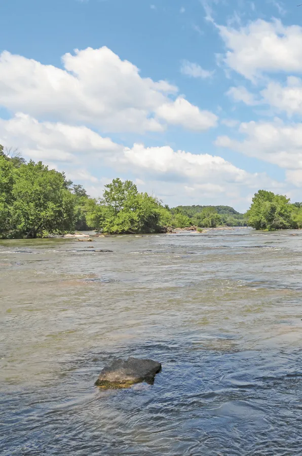
Soak up this view of the Yadkin River while hiking at Pilot Mountain State Park.
∎ Piedmont
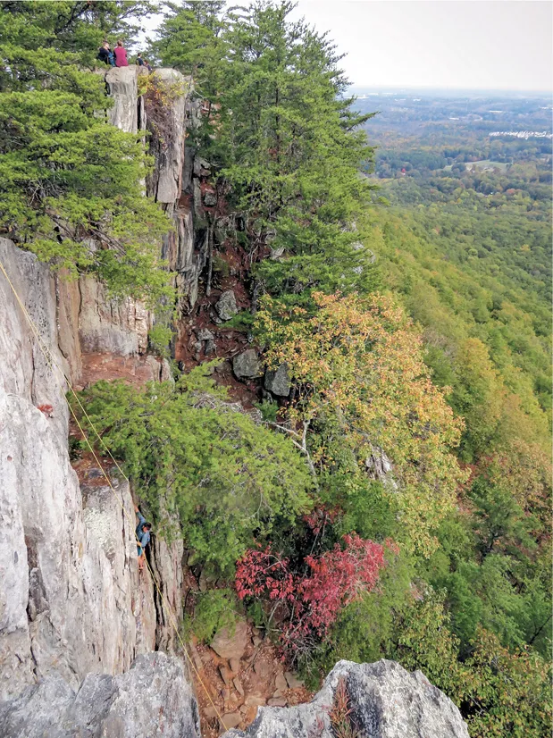
Hikers and climbers enjoy the outcrops atop Crowders Mountain.
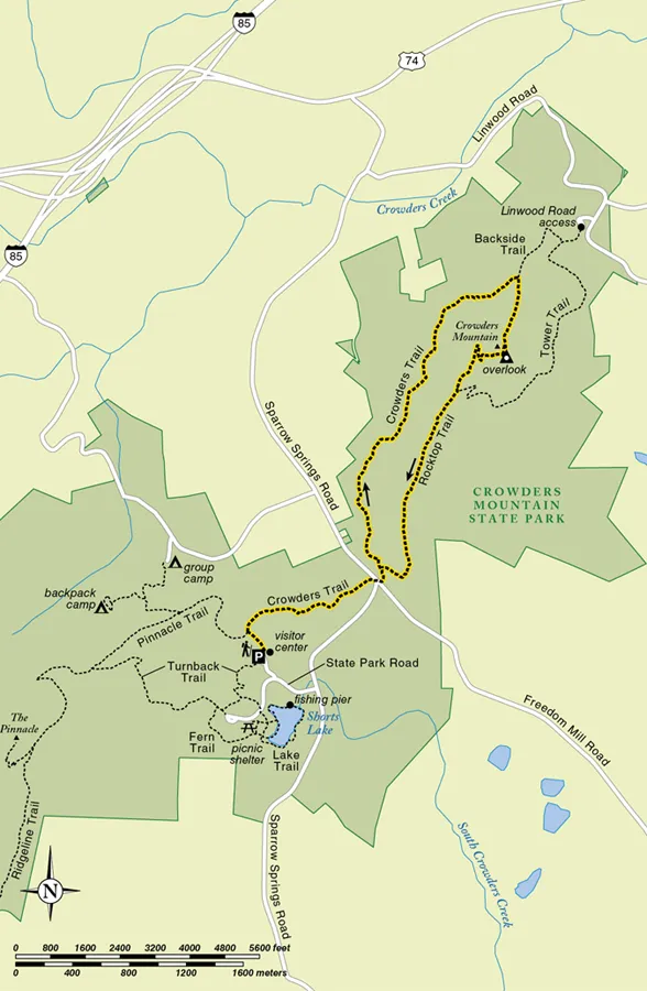
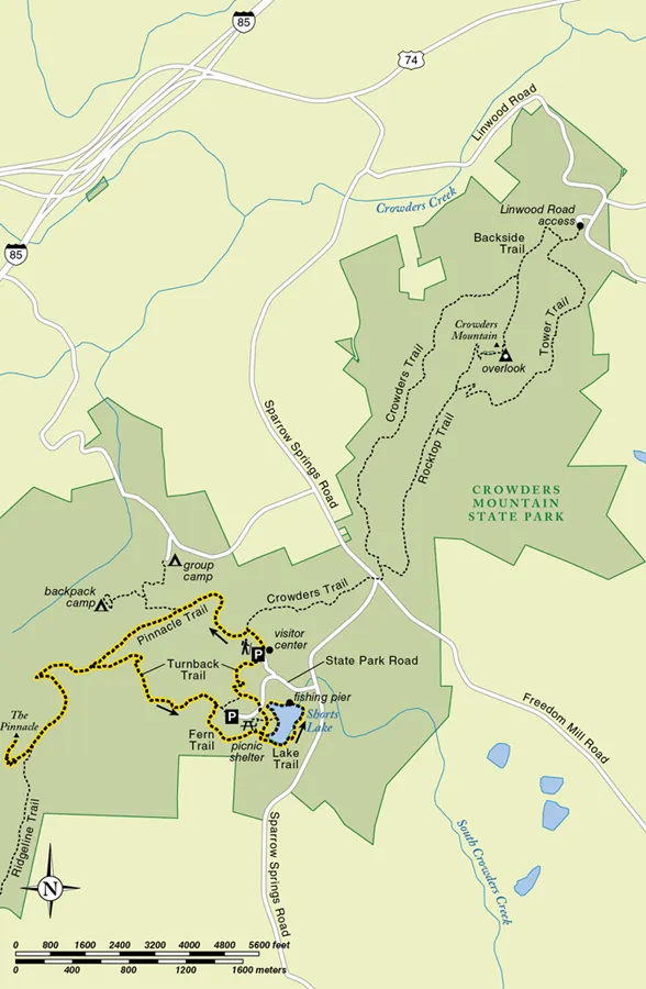
14 CROWDERS MOUNTAIN CIRCUIT
Crowders Mountain State Park
This busy and rewarding hike at Crowders Mountain State Park will surprise. Leave the trailhead to ramble through woods and come along the west slope of Crowders Mountain. Then climb the peak to a rocky overlook where exclamatory views extend as far as the eye can see. Maneuver along the stony to the extreme Rocktop Trail, enjoying more distant vistas before completing the loop. The going is slow on the Rocktop Trail, and the trailhead parking area—and trails—can fill on weekends.
Distance 5.4-mile balloon loop
Hiking time 3.0 hours
Difficulty Moderate, does have rocky, slow sections and 500-foot climb
Highlights Views, geology
Cautions Rocktop Trail involves a bit of clambering among boulders
Best seasons Year-round, though summer can be torrid
Other trail users None
Hours December–February, 8 a.m.–6 p.m.; March–April, October, 8 a.m.–8 p.m.; May–September, 8 a.m.–9 p.m.; November, 8 a.m.–7 p.m.; closed Christmas Day
Trail contact Crowders Mountain State Park, 522 Park Office Lane, Kings Mountain, NC 28086, 704-853-5375, www.ncparks.gov/crowders-mountain-state-park
Finding the trailhead From Exit 13 on I-85 east of Gastonia and west of Charlotte, take Edgewood Road South for .7 miles, then turn right onto US 74W / US 29S. Follow it for 1.8 miles to turn left onto Sparrow Springs Road. Follow Sparrow Springs Road for 2.5 miles, then veer right to stay on Sparrow Springs Road. Follow it for .6 mile farther to turn right into the state park, and follow the main road to turn right to the park visitor center.
GPS trailhead coordinates 35.213306, −81.293556
The two peaks of Crowders Mountain State Park—Crowders Mountain and The Pinnacle—rise from the Piedmont in stony splendor, providing this growing area a place to enjoy nature while hiking. And did I mention the views? You will be well rewarded for your efforts with first-rate vistas from montane cliffs rising above the lowlands below. However, the park’s popularity may be its primary detraction. If possible, avoid the crowds by visiting in the morning or evening and avoiding obvious times when the park will be crowded. Your experience will be better that way, and you’ll reduce the strain on the park’s resources from overly concentrated visitation.
By all means do visit. You can’t miss the views. Start out by finding the correct trailhead. As you face the park visitor center, look left for a map and kiosk. Join the wide natural-surface track, heading northbound. Cruise through flatwoods. At .1 mile, turn right with the Crowders Trail, as the Pinnacle Trail leads left. Hickories and oaks shade the heavily used trail, with many an exposed root. At .4 mile, cross a small stream under boughs of mountain laurel.
At .8 mile emerge onto and cross Sparrow Springs Road. By now you will have noticed trailside markers adorned with a number, helping rangers locate hikers when trouble arises. At .9 mile, come to a trail intersection. Head left here, staying with the Crowders Trail under pine oak, hickory, sourwood, and sweetgum, along with wild azalea and sparkleberry. Begin working north along the west slope of Crowders Mountain. Standing boulders and outcrops are common. Cross occasional wet-weather drainages flowing off Crowders Mountain.
At 2.1 miles, the trail becomes rockier, traversing little boulder fields. Circle to the north side of the mountain, reaching a trail intersection at 2.6 miles. Here, turn right on the Backside Trail, climbing a doubletrack. Stone cliffs rise to your left. At 3.0 miles, the trail angles left, where you’ll make the final climb using seemingly endless steps. Come to a crag on the ridgecrest at 3.1 miles. Carefully explore these cliffs, which open onto implausible panoramas, mostly to the east. Charlotte’s skyline rises in the distance, along with hump-like hills escalating above the Piedmont. Be careful—the rock is jagged and irregular—but do look around, to the south and also north.
From the overlook, pick up the Rocktop Trail, heading south to climb to radio towers at the peak. Scoot directly beside the towers to reach a doubletrack tower access road. Here the Rocktop and Tower Trails run in conjunction. Descend by switchbacks to reach an intersection at 3.6 miles. At this juncture, the doubletrack Tower Trail splits left and continues a downgrade, while we stay right on the now-narrow Rocktop Trail, keeping south along the ridge. Here the path becomes unbelievably rocky in places, scattered with pines and offering many a vantage point to both east and west from adjacent outcrops. Look for The Pinnacle to the south. In places you will scramble amid boulders, following the red blazes, sometimes painted onto the rock, to help you through the maze. The hiking is fun, but slow. Allow for the extra time so you can enjoy the ride.
At 4.4 miles, continue descending past eye-catching rock crags rising to your left. Just ahead, leave the stony razorback behind, traveling a dirt path through bucolic woods, quite a change from the adventure along the ridge of Crowders Mountain. At 4.5 miles, meet the Crowders Trail to complete the loop portion of the hike. From here, backtrack to the trailhead, finishing this rocky, exciting North Carolina state park adventure.
Mileages | 0.0 Visitor center trailhead 0.8 Cross Sparrow Springs Road 1.5 Stay with Crowders Trail 2.6 Join Backside Trail 3.1 Vista 4.5 Complete loop portion of hike 5.4 Visitor center trailhead |
15 THE PINNACLE HIKE
Crowders Mountain State Park
This first-rate hike at Crowders Mountain State Park makes a loop that first leads you to The Pinnacle, a rocky peak with extensive views from its stony summit. From there, the Turnback Trail takes you down to Shorts Lake. Circle the still waters in attractive woods, enjoying sights both high and low before returning to the trailhead.
The Pinnacle at Crowders Mountain State Park is aptly named. Rising like the crown of a king, with sheer cliffs at its apex, The Pinnacle rises nearly 700 feet from the surrounding Piedmont, making it not only a beacon but also an excellent vantage point, where you can see to the horizon in all directions. The park came to be in the 1970s, when mining interests wanted to extract minerals from the locale. Nearby Gastonia residents banded together and encouraged the state to instead purchase the land for a state park. It did, and Crowders Mountain State Park has since been expanded twice; it now links to Kings Mountain National Military Park in nearby South Carolina.
Distance 5.5-mile double loop
Hiking time 3.0 hours
Difficulty Moderate, does have 750-foot climb
Highlights Views, geology, lake
Cautions None
Best seasons Late summer through late spring
Other trail users None
Hours December–February, 8 a.m.–6 p.m.; March–April, October, 8 a.m.–8 p.m.; May–September, 8 a.m.–9 p.m.; November, 8 a.m.–7 p.m.; closed Christmas Day
Trail contact Crowders Mountain State Park, 522 Park Office Lane, Kings Mountain, NC 28086, 704-853-5375, www.ncparks.gov/crowders-mountain-state-park
Finding the trailhead From Exit 13 on I-85 east of Gastonia and west of Charlotte, take Edgewood Road South for .7 miles, then turn right onto US 74W / US 29S and follow it for 1.8 miles to turn left onto Sparrow Springs Road. Follow Sparrow Springs Road for 2.5 miles, then veer right to stay on Sparrow Springs Road. Follow it for .6 mile farther to turn right into the state park, and follow the main road to turn right to the park visitor center.
GPS trailhead coordinates 35.213306, −81.293556
Today this is a very popular state park. This hike takes you to the views from The Pinnacle as well as to Shorts Lake, a relic impoundment of latter-year farm families who owned the land that became this preserve. Begin your adventure at the park visitor center. As you face the visitor center entrance, look left for a map board and kiosk. Join the wide natural surface track, northbound. Cruise through flatwoods. At .1 mile, head left with the Pinnacle Trail as the Crowders Trail leads right. Gently ascend among sourwood, hickory, oak, black gum, and pines. At .6 mile, a spur trail leads right to the park backcountry campground. It offers hike-to campsites with picnic table and fire ring. I’ve overnighted there myself and recommend the experience. We stay with the Pinnacle Trail, running a piney ridgeline thick with rock outcrops and chestnut oaks.
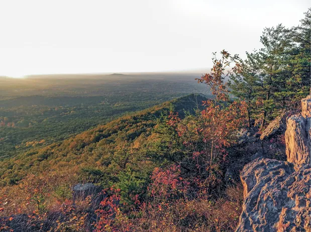
The Piedmont stretches across the morning horizon from the Pinnacle Trail.
At 1.1 miles, meet the Turnback Trail in a gap. You will return here later, but for now stay with the Pinnacle Trail, climbing steadily to swing around to the east side of the mountain. Avoid shortcuts. At 1.8 miles, at the base of The Pinnacle, the Ridgeline Trail goes south, eventually leaving N...