![]()
1
The Crossroads of the Middle Colonies
The People, Society, and Environment of Staten Island
On October 30, 1748, Peter Kalm, a protégé of the Swedish botanist Carolus Linnaeus, boarded “a wretched half rotten ferry” at Elizabethtown, New Jersey,a that took him across the Arthur Kill.b “As soon as we had got over the river, we were upon Staten Island,” he wrote in his travel journal, adding, “this is the beginning of the province of New York.” As he crossed the island, Kalm was fascinated by its physical and cultural landscape. “The prospect of the country here is extremely pleasing,” he commented. “It offers more cultivated fields” than anywhere else, and its topography is broken at places by “hills and valleys.” Although Kalm often had been optimistic about other places he visited, in this particular case it was true. He also noticed that “most of the people settled here were Dutchmen, or such as came hither whilst the Dutch were yet in possession of this place, but at present they were scattered among the English and other European inhabitants.” Staten Islanders “spoke English for the greatest part,” Kalm noted, and established prosperous farms located close to one another. Kalm ended his trip to the island the next day by boarding another ferry “to cross the water, in order, to come to the town of New York.”1
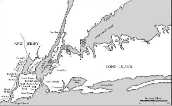
Staten Island is located about ten miles southwest of Manhattan at the confluence of the Hudson, Passaic, and Raritan rivers. Roughly 13.9 by 7.3 miles at its maximum dimensions, the island measures 57.1 square miles, or about 36,600 acres. The island’s eastern shore borders upper New York Bay, and its western shore runs along the Arthur Kill, a waterway that separates Staten Island from New Jersey at distances of often less than five hundred feet. The Kill van Kull and Newark Bay separate the island’s northern shore from New Jersey’s Bayonne peninsula, and its southern shore runs along the Atlantic from lower New York Bay to Raritan Bay. The Narrows, a body of water one mile wide that is located at the entrance to New York Harbor, separates Staten Island from the western end of Long Island. Two ridges of hills rise up from the island’s landscape, the taller of which is more than four hundred feet and runs six miles from the eastern shore to the center of the island,c with the smaller ridge extending southwest from the Narrows and rising to more than 170 feet. Staten Island’s extensive shoreline is broken by numerous coves and inlets, shallow bays, and tidal marshes. The island’s topographic features—its proximity to New York City, New Jersey, and Long Island, its location at the entrance to New York Harbor, and its extensive shoreline—not only give Staten Island important regional and economic advantages but also provide a valuable strategic military site.
Adapted from the map of the progress of His Majesty’s armies in New York during the late campaign, illustrating the accounts published in the London Gazette, ca. 1776. Courtesy of the Staten Island Historical Society.
Today, the dense development of suburban townhouses and malls makes it difficult to imagine the physical landscape and the natural abundance that Peter Kalm encountered on Staten Island more than two centuries ago. The many creeks, streams, and brooks that once flowed through the island, gave its residents access to regional marketplaces, and were ideal “for fishing and catching oysters and for being near salt meadows” are now only distant memories replaced by paved streets, storm sewers, and landfill.2 Staten Islanders also once used the flow of these waterways to power their mills and dug rudimentary channels to divert the fresh water to their fields. Along the shores of Staten Island’s waterways, tidal marshes, and bays grew thick fields of tall salt grass that settlers valued as an important source of hay to fatten their livestock. Moreover, the island’s fisheries were so plentiful that a fisherman’s average daily catch was fifty to one hundred pounds. “The haul of fish on the sand banks of Staten Island and the Raritan Bay is most remarkable,” observed Captain Philipp Waldeck, the chaplain of the Third Waldeck Regiment of Hessian Troops stationed on the island during the American Revolution.3 In addition to fishing, residents harvested oysters, clams, and crabs from the Kill van Kull, Arthur Kill, and Raritan Bay. Fish, oysters, crabs, and clams were an extra source of food and popular with consumers in New York City and the market towns of New Jersey.4
Staten Island’s most important internal water system was the Fresh Kills and its tributaries. The Fresh Kills, which has become synonymous with the landfill that occupied its space during the twentieth century, was a broad tidal marsh interspersed with islandsd and small peninsulas. It opened to the Arthur Kill and was fed by the Richmond Creek and the Main Creek. Both creeks meandered through the Fresh Kills marsh and were navigable for more than a mile, giving residents who lived in the interior an outlet to the Arthur Kill and a good source of salt grass.5 Sales advertisements for farms located near the Fresh Kills and its tributaries highlighted the waterway’s ability to accommodate vessels of up to fifty tons. Peter Kalm described the value to residents of the Fresh Kills marsh with its salt grass: “The country was low on both sides . . . and consisted of meadows. But there was no other hay to be got, than such as commonly grows on [these] swampy grounds.”6
Many of Staten Island’s internal waterways were irrigated by a collection of natural springs fed by numerous underground sources. These springs supplied clean water to residents, who hauled it in pails and barrels to their farms. The most famous Staten Island natural spring was the Watering Place. Located on the eastern shore near the Narrows, the Watering Place was an important source of good drinking water for the crews of ships sailing from the port of New York out to sea, ensuring that they would stop at the island. As one visitor wrote, “The eastern part [of Staten Island] . . . is the usual place where ships, ready for sea, stop to take in water . . . previous to their departure.”7 The Watering Place on Staten Island also was attractive to the British military, which established a major staging area there in 1761 during the French and Indian War (1754–1763).
Until the American Revolution, Staten Island was “as well timbered as any part of America,”8 covered by a dense hardwood forest of predominantly red and white oaks, firs, cedars, and hickories as well as chestnuts, walnuts, locusts, and white ash. As Daniel Denton observed in a brief promotional tract in 1670 designed to encourage English settlement in areas of the former New Netherland, Staten Island’s “excellent good land” facilitated the growth of “black walnut and locust as . . . in Virginia, with mighty tall, straight timber.”9 Two Dutch travelers, Jasper Danckaerts and Peter Sluyter, found “nothing but woods” as they walked across the island in 1679. With some exaggeration, they recalled that they “could see nothing except a little of the sky through the thick branches of the trees above our heads.”10 Staten Islanders made good use of the forest for building, heating, and fencing materials and other products such as barrels. They also sold cordwood to consumers in New York City and Perth Amboy, New Jersey.11 In addition, the island’s proximity to several commercial centers, combined with the richness of its woodlands, supported the development of shipbuilding. By 1770, two residents, Joshua Mersereau and Richard Lawrence, had established competing shipyards along the Kill van Kull that built small boats for coastal fishing and local transport.12
Although the sea and the forest provided sources of income to Staten Island’s residents, it was farming that sustained their livelihoods. Staten Island’s “climate and soil are without exception, the loveliest, the healthiest, and the most agreeable on the face of the globe,” reported a visitor, adding that “a person, were he so disposed, could easily lay here the foundations of a great fortune for his progeny should he invest a reasonable sum in land.”13 By the time of the American Revolution, less than 5 percent of Staten Island’s white male residents were non-land-owning tenants.14 Instead, the island was a community of middle-class yeomen and their families who owned farms ranging in size from eighty to 275 acres. The one exception was Bentley Manor, the 1,600-acre south shore estate owned by the wealthy and politically powerful Billopp family.15
Only part of each farm was devoted to cultivation; the rest was valuable woodlands, untilled pasture, and salt grass. Wheat was the main crop and a major component of their trade networks. After wheat, Staten Island’s principal crops were rye, barley, Indian corn, and buckwheat. Staten Islanders also grew small amounts of tobacco and flax, the latter of which, when spun, produced linen for bedding and clothing. Large orchards of apples, cherries, peaches, and pears were found wherever there were houses. On his journey through Staten Island in 1748, Peter Kalm noticed that “near every farmhouse was an orchard with apple trees and cherry trees” and that these orchards “stood . . . round corn fields.” The fields that he observed were “excellently situated, and either sown with wheat or rye.”16 In addition, vegetables were grown in island gardens, as well as grapes, berries, melons, and nuts. Residents grew oats and clover to feed to the livestock and horses that they “raised [in] immense quantities.”17 They raised cattle, sheep, and hogs for sale at local urban markets and also for their meat, milk, cheese, and butter to consume and to sell. Horses and oxen hauled wagons and pulled plows. Poultry provided Staten Islanders with meat and eggs, and bees were kept for honey, beeswax, and pollination.
Staten Island’s preindustrial economy was apparent in the residents’ reliance on household production for many of their basic needs. Indeed, their survival and economic success depended on the contributions of individual family members and white indentured servants, African American slaves, and hired laborers. Artisans did not comprise an important or separate class on Staten Island. Instead, many items were crafted at home by farmers, as demonstrated by the tools for specialized crafts frequently appearing in their estate inventories and wills. Wives and daughters helped the male family members by spinning wool and flax, butchering animals, milking cows, maintaining gardens, and preparing and preserving food.
Although they relied on household production for many of their basic needs, Staten Island’s farmers were not self-sufficient yeomen. Instead, they participated to a greater or lesser extent in the eighteenth century’s transatlantic market economy through local networks of barter and exchange, cash transactions and bills of credit, and the purchase of slaves. Two major settlements were located on the island: Richmond (in the center of the island) and Decker’s Ferrye (on the Kill van Kull), both serving as transportation and commercial hubs. Here merchants and shopkeepers bought and sold a variety of goods and offered the island’s farmers basic commercial services.
The success of Staten Island’s commerce depended on these local merchants and shopkeepers as well as the mills that processed its raw materials into marketable commodities, the roads that linked its settlements and farms, and the ferries that connected the island to the surrounding region. In fact, the best and quickest routes between New York City and Philadelphia, the colonies’ two largest commercial centers, were by ferry from New York City to Staten Island and then across the island to ferries that transported people and livestock as well as freight wagons and stagecoaches to numerous landings in Bergen Point,f Elizabethtown, Wood-bridge, and Perth Amboy, New Jersey. From these landings, roads led through New Brunswick and Princeton to Trenton, on the eastern bank of the Delaware River. Then at Trenton, passengers and cargo were transferred to ferries bound for Philadelphia.18
Both eighteenth-century American towns and cities and farmers needed the other to prosper, as exemplified by Staten Island’s connection with the surrounding towns and cities. But this connection was not exclusively with New York City. Unlike the farmers in Westchester County and in Kings and Queens counties on Long Island who relied solely on the New York market, Staten Islanders had the option of also sending their commodities to urban markets in New Jersey. As a result, Staten Island’s grains, flour, fruits and vegetables, fish, livestock, flaxseed, cordwood, and lumber were sold in the markets of Elizabethtown, which was New Jersey’s largest municipality, in Perth Amboy, one of the colony’s twin capitalsg and a port of some consequence, and in Woodbridge, a crossroads town of artisan shops and small farms founded by Quakers and lying adjacent to Perth Amboy. The bulk of goods brought back to Staten Island from New York City or the markets located in New Jersey met its residents’ needs: housewares, food items, furniture, cloth, and garments from different parts of the transatlantic world. Indeed, the appearance of these items in Staten Island’s homes shatters the perception of it as an isolated community dominated by subsistence agriculture. Instead, Staten Islanders actively participated in the consumer revolution of the eighteenth century, comprising a community sophisticated and wealthy enough to provide a market for these items.19
Clandestine channels also offered a way to obtain consumer goods and money. Staten Island was a smuggler’s haven, as were the larger ports of Philadelphia, New York, and Boston, as well as several smaller seaboar...