![]()
PART I
Beginnings
Introduction to Part I
From the beginnings of Japanese history to the present, the geography of the islands has played a continuous role in shaping their biosystem and the civilization it sustained. Because the influence of geology, climate, and biota has been active and ongoing, it is insufficient to treat these variables as passive context by simply describing them at the outset and disregarding them thereafter. Lest the overall character of the geography be missed, however, it seems helpful to examine it as a whole before plunging into a narrative history that deals predominantly with human affairs. That history begins with foragers, a “pre-history” that can be examined in terms of an earlier, ill- recorded paleolithic culture, a later, much more richly evidenced culture commonly called Jomon after its pottery, and from about 400 years before the common era (BCE) onward the appearance of an agricultural order that spread eastward across the archipelago from Kyushu.
Chronology of Part I
| By 130,000 yBP | Humans present. |
| 32,000 yBP | Evidence of paleolithic culture. |
| 12,700 yBP | Evidence of pottery usage. |
| 4,500 yBP | Jōmon apex. |
| 2,500–2,400 yBP (5–400 BCE) | Rice culture in northwest Kyushu. |
| 400 BCE–250 CE | Agriculture becomes established in Japan. |
![]()
[1]
GEOLOGY, CLIMATE, AND BIOTA1
CHAPTER SYNOPSIS
JAPAN’S GEOGRAPHY TODAY
THE GEOLOGICAL HERITAGE
THE INFLUENCE OF CLIMATE AND OCEAN CURRENTS
THE BIOTIC INHERITANCE
Knowledge of geography is essential for all historians, and for none more so than students of Japan, because geographical variables have affected all three facets of its history: production, distribution, and representation. In terms of the last, geography is important because place and season are central referents in a wide array of records and creative works. Place names and ecosystem terms are alive with meaning. Words such as akamatsu (red pine), baiu (rainy season), yuki (snow), and ume (plum) evoke images of season and circumstance as richly as they do poem and painting. And place names – Kyoto, Kantō, Nagasaki, Tosa, or Yoshiwara – resonate at many levels, eliciting layer upon layer of significance and sensibility. Not to know those layers denies one access to much of the history’s richness and means that one cannot know what that history signifies to those who do.
Much of the charm of geography lies, therefore, in its function in the representation of history. Its more essential quality, however, lies in its key role in shaping patterns of production and distribution. Both general characteristics and specific factors – e.g., the depth and distribution of Kantō loam, ruggedness of the Kii peninsula’s coastline, Mt. Asama’s volcanic eruptions, the Inland Sea’s location, or Yodo River silting – all in large or small ways have shaped those facets of history.
The basic physical geography of Japan has changed very little during the centuries of its written history, so describing the island chain as it is today pretty much describes it for the past two thousand years. Over the longer duration of its human habitation, however, Japan has experienced major geographic changes, and because those changes not only affected the experience of all creatures living there at the time but also determined the archipelago’s present-day character, its geological heritage merits examination. Climate and biota also have played important roles in shaping its history.
JAPAN’S GEOGRAPHY TODAY
Today Japan consists of the four major islands of Hokkaido, Honshu, Kyushu, and Shikoku, a few sizable nearby islands, and innumerable islets, most notably those of the southward-running Ryukyu and Bonin island chains. (See map 2.) The country’s gross land area is about 378,000 square kilometers, roughly the size of Germany, Montana, or Zimbabwe. Of that total area, about 56,000 square kilometers are in cultivation while the rest, mostly mountains, are devoted to forest, pasture, or urban uses.
Lying along the eastern edge of Eurasia, Japan extends from about 31° north latitude at the southern tip of Kyushu to 45° near the northern end of Hokkaido. The climate ranges from subtropical to cold temperate, and indigenous forest vegetation ranges similarly from evergreen broadleaf in the south through deciduous broadleaf in much of central Japan to coniferous boreal forest in Hokkaido and at higher elevations in Honshu.
Today, as for the past few thousand years, the bulk of Japan’s human population is situated along an east–west axis that runs from northern Kyushu through the Inland Sea to the Kinai basin and the Nobi and Kantō plains, the last of which is the largest area of flat land and the site of megapolitan Tokyo. This elongated strip of central Japan has dominated the country’s human history because the Inland Sea provided convenient, reasonably safe transportation and was lined with small but productive and comfortable coastal plains and their richly wooded hinterlands. The Kinai, Nobi, and Kantō plains, all endowed with attractive climates, provided agricultural foundations large and fertile enough to support political organizations that ambitious leaders could employ to conquer outlying populations.
The long-term social domination enjoyed by this Inland–Sea-centered axis has helped sustain ill-defined but enduring regional tensions, most notably that between residents of southwest and northeast Japan. The tension was fostered from early times, it appears, by the entry of diverse continental peoples into Japan via the “land bridges” that periodically linked Kyushu and Sakhalin to the continent, the most recent ones being submerged by rising sea levels about 13,000 years ago. In later millennia the regional distinctions were sustained by differences in the floral composition of Japan’s forests. Specifically, the deciduous forests that prevailed from central Japan northeastward enabled that region to sustain a more dense and durable forager culture than could the evergreen stands of the southwest, which proved less supportive and instead encouraged the adoption of rice culture some 2,400 years ago (400 BCE) . In subsequent centuries enduring differences in cultural pretensions and economic conditions nurtured regional hostility and outright warfare, most persistently between the “civilized” west and “barbarian” east. Recently the tension was given harsh expression in civil wars of the 1860s, and it persisted through the twentieth century in the form of political and cultural rivalries and resentments.
THE GEOLOGICAL HERITAGE
From the perspective of the individuals whose passage has produced Japan’s human history, the archipelago was and is a large and variegated place in which to live. From a broader global perspective, however, it is a small realm whose character has been determined by the very tectonic processes that shaped the history of the entire planet.
Like earthlings, after all, the Earth does have a history, and Japan’s place in it can be outlined briefly. Compared to our universe, with its postulated birthing date of some fourteen billion years ago, Earth is a newcomer, taking shape less than half that long ago. By two billion years ago its surface structure of continental and oceanic plates had formed and those plates were embarked on the convoluted journeys that led them eons later, some 250 million years ago, into the great clustered configuration known as Pangaea.
The location in Pangaea of that segment of continental plate that we know today as Japan is not certain, but recent soundings indicate that the northerly half was situated on the northwestern margin of the super continent, at the edge of what geologists identify as the North American Plate. As the Earth’s internal churnings started disassembling Pangaea some 200 million years ago, that plate was propelled westward, overriding the great Panthallasic Ocean (today’s Pacific and Philippine Sea Plates) until its leading edge encountered the northeast section of Pangaea, today’s Eurasian Plate. That plate was making a long, pivoting journey southeastward, which drove it roughshod over the Philippine Sea Plate. The area we know as northeast Japan collided with that descending Eurasian Plate in the vicinity of today’s Korea, and the force of that collision eventually forced a fragment of the latter plate to pivot away to the southeast, where it became the foundation for today’s southwestern Japan. That pivoting movement created a deep marine depression, which we know as the Sea of Japan. The immense pressure of that collision was expressed in folding, faulting, and volcanism, and the record of those processes is preserved today in Japan’s profoundly complicated geology, most strikingly in the Nagano region where the plates collided with particular harshness.
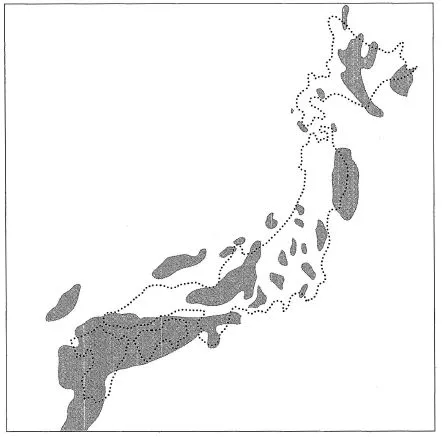
Ever since the post-Pangaea collision started some hundred million years ago, Japan has continued to twist and churn, regions irregularly rising and falling as the balance repeatedly shifted between eruptive tectonic pressure and reductive erosion (see figure 1.1). As that figure suggests, much of present-day Japan was under water some fifteen million years ago, and not until about five million years ago did the area commence its present orogeny, the rapid mountain building that has formed the archipelago we know today. Compared to the Appalachian and Ural mountains, which are a half-billion or so years old, or the Rockies, Himalayas, and Alps, which date back tens of millions, the mountains of Japan are remarkably young, having gained much of their present height during the past two million years.
About two million years ago (for reasons having to do with atmospheric composition, continental and oceanic configuration, or the tilt of Earth’s axis and the shape of Earth’s solar orbit) the planet entered a period of frequent glaciations that is still in progress. By then, the Pleistocene epoch, Japan consisted of an elongated cluster of intersecting mountain ranges and deposition plains that flanked the continent but were separated from it by the Sea of Japan. It was bounded by shallow seas to the southwest, deep oceanic trenches to the south and east, and shallow straits in the north. Depending primarily on the ebb and flow of glaciation and the resulting rise and fall of sea level, Japan was isolated periodically as a set of islands or joined to the continent by stretches of coastal lowland – “land bridges” – that extended westward from Kyushu and Sakhalin.
Figure 1.1 The Miocene archipelago (shaded areas). (A reconstruction of terrestrial areas, ca. 15 million yBP – Middle Miocene.) Much of present-day Honshu was below sea level fifteen million years ago, and more recent orogenies have completely rearranged topography throughout the archipelago.
Source: Takashi Yoshida, An Outline of the Geology of Japan, 3d edn (Kawasaki: Geological Survey of Japan, 1976), p. 19.
The physical record of early glacial cycles has largely been erased by subsequent fluctuations in sea level, but the rhythm of the most recent cycle is etched clearly all along the archipelago’s coastline. As of 75,000 years ago, when a warm interglacial period was ending, Japan was isolated from the continent. Fluctuating but generally colder millennia followed, and, while the dating is uncertain, as of 30,000 years ago land bridges evidently existed between Kyushu and Korea and between Hokkaido, Sakhalin, and the Amur region of Siberia. This cold phase, the final stage of the Würm or Wisconsin glaciation, climaxed around 18,000 years ago, with sea level some 130–140 meters below today’s. Japan’s main islands were united, and southwest Japan was linked to the continent via a coastal plain covered with temperate deciduous forest growth and bisected, one suspects, only by a broad river that drained a body of water nearly twice the size of the Black Sea. (See figure 2.1, p. 22.)
During the millennia when sea level was dropping, the existing coastal plains gradually eroded, leaving residual “terrace deposits” of regolith along the flanks of newly formed river valleys. Later, as global warming occurred, especially between 13,000 and 12,000 years ago, those valleys filled with seawater and sediment. The ocean’s transgression over glacial-age coastal low-lands and valleys once again restored Japan’s island character, with the rise in sea level peaking about 6,000 years ago when global temperatures were appreciably higher than at present. By then silting had filled in the former river valleys, and when a new but modest phase of global cooling lowered sea level several meters during the next 2,000–3,000 years, substantial areas of coastal plain re-emerged all along Japan’s shoreline. These constituted much of the flat land that is now occupied by cities, towns, and paddy fields.
This geological legacy is evident today. The ceaseless squeezing between continental and oceanic plates has produced an extraordinarily complex series of mountain ranges that extend northward to form Sakhalin and the Kuril Islands and southward to form the Bonin and Ryukyu island arcs. In Japan proper the process has created a mosaic of central ridgelines with branching spurs that constitutes the archipelago’s backbone (see map 4). In Honshu, at the interface of northeast and southwest Japan, a central cordillera of closely dissected ranges makes Nagano and adjoining prefectures a labyrinth of narrow valleys whose rushing rivers twist and turn between ranges with peaks that rise well beyond the tree line, several exceeding 3,000 meters above sea level.
Because the orogenic activity that created Japan’s mountains is so recent, they thrust skyward with exceeding abruptness, culminating in sharp peaks and ridges that are subject to uncommonly rapid erosion. During downpour and snowmelt debris-laden waters thunder down rock-strewn streams and rivers that descend precipitously to the lowlands, where the detritus settles out to form stony alluvial fans and sedimentary flood plains.
The tectonic stresses that fueled Japan’s rapid mountain building during the most recent five million years also produced the volcanism that dotted the realm with its large number of volcanoes, lava and ash surfaces, and areas of continuing geothermal activity. Indeed, Japan’s 60-odd active volcanoes constitute about 10 percent of those known to be currently active around the globe.2 Over the millennia the ash that spewed from them washed into lakes and shallow coastal waters, helping form sedimentary plains and maturing into loams supportive of a rich lowland vegetation. The most well known of these ash deposits is a series of deep layers produced during spurts of eruption over the past 350,000 years by the Asama and Akagi volcanoes northwest of Tokyo and by a cluster of other vents in the Hakone region, of which Mt. Fuji is by far the grandest and newest. Ash from these peaks has blown and washed eastward, settling out to produce the rich layers of loam that form the modern Kantō plain.
The mountains produced by tectonic activity constitute about 80 percent of Japan’s modern land surface. The other 20 percent is sedimentary terrain of two types. Scattered widely about Japan are residual areas of Pleistocene sedimentation known as diluvium, the eroded remnants of plains formed mainly during inter-glacial periods of high sea level 50,000 or more years ago. Subsequently elevated by crustal movement and volcanic fallout and eroded by renewed stream action, these remnants survive today as terrace deposits – mostly hillocks and low-lying ridges of unconsolidated material that rise anywhere from 10 to 300 meters above adjacent alluvial plains. These latter plains, the bulk of present-day flatland, were formed, as noted above, following the last major glacial period. Most emerged from the sea during the cooling that commenced some five to six thousand years ago.
Two characteristics of this geological legacy merit particular emphasis. First, unlike most large areas of dense human population, Japan lacks tectonic flatlands: i.e., horizontal bedrock of either pre-Cambrian or later origins. Instead, its flatlands are small, sedimentary basins most of which are bounded by steep mountain slopes. This means that beyond the flatland there are almost no gradually rising plains or hill country that can, with somewhat more labor, be turned to human use. Nor are the alluvial fans and diluvial terraces that do exist especially beneficial. Because the mountains rise so sharply and streamflow carries so much debris, fans at the upper ends of valleys phase quickly through loam to sand, gravel, and finally rock-infested soil of little agricultural value. And the terrace deposits frequently are of limited utility because many consist of coarse, leached soils of low fertility, and their slopes are so acute that they erode easily when disturbed, damaging the good land below. Consequently, once a human community has developed the productive potential of its flatlands, it has very little marginal area into which it can expand; the transition from ampleness of resources to ecological overload is an unusually abrupt one.
Second, although late Pleistocene glacial epochs were decisive in shaping Japan’s lowlands, the region was not itself covered with ice. Except for a few small mountain glaciers, Japan was not subjected, in the manner of northerly North America and Europe, to the grinding activity of ice that scoured and lowered mountain ridges, leaving bare rock faces and depositing the regolith in irregular patches of glacial till that could disrupt surface and subsurface water-flow. In consequence Japan’s mountains have retained their height and sharpness and the shallow, stony soil that supports a fairly even forest cover. For lowlands, the absence of extensive glacial residues means that natural drainage systems have remained more regular in configuration and hydrologic behavior than in areas where glacial activity has occurred. This more orderly lowland topography has fostered uniformity and regularity in land use patterns – notably irrigated rice culture – and in the social arrangements that accompany them.
THE INFLUENCE OF CLIMATE AND OCEAN CURRENTS
At the most general level, two major climatic forces determine Japan’s weather. Prevailing westerly winds move across Eurasia, sweep over the archipelago, and continue eastward across the Pacific Ocean. And great cyclonic air flows that arise over the western equatorial Pacific wheel northeastward across Japan and nearby regions. During winter months heavy masses of cold air from Siberia dominate the weather around Japan. Persistent cold winds skim across the Sea of Japan from the nort...