- 560 pages
- English
- ePUB (mobile friendly)
- Available on iOS & Android
eBook - ePub
Global Geomorphology
About this book
The plate tectonics revolution in the earth sciences has provided a valuable new framework for understanding long-term landform development.
This innovative text provides a comprehensive introduction to the subject of global geomorphology, with the emphasis placed on large-scale processes and phenomena. Integrating global tectonics into the study of landforms and incorporating planetary geomorphology as a major component the author discusses the impact of climatic change and the role of catastrophic events on landform genesis and includes a comprehensive study of surface geomorphic processes.
Trusted by 375,005 students
Access to over 1.5 million titles for a fair monthly price.
Study more efficiently using our study tools.
Information
Part I
Introduction
1
Approaches to geomorphology
1.1 The science of landforms
Geomorphology is the science concerned with the form of the landsurface and the processes which create it. It is extended by some to include the study of submarine features, and with the advent of planetary exploration must now incorporate the landscapes of the major solid bodies of the Solar System. One focus for geomorphic research is the relationship between landforms and the processes currently acting on them. But many landforms cannot be fully explained by the nature and intensity of geomophic processes now operating so it is also necessary to consider past events that may have helped shape the landscape. To a significant extent, then, geomorphology is a historical science.
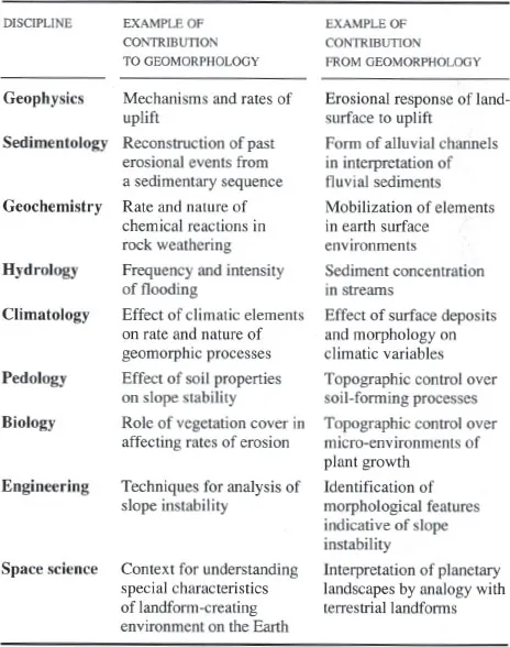
Since the landsurface is located at the interface of the Earth’s lithosphere, atmosphere, hydrosphere and biosphere, geomorphology is closely related to a wide range of other disciplines (Table 1.1). While having a central interest in landforms, geomorphologists must, none the less, be aware of those aspects of allied disciplines that bear on their subject. Equally, geomorphology has a potential, as yet only partially realized, of making significant contributions to these other areas of knowledge.
Table 1.1 Examples of relationships between geomorphology and allied disciplines
1.2 The development of ideas
The way geomorphologists approach the study of landforms at the present time can only be seen in a proper context if we appreciate how the central concepts of geomorphology have been developed. Long before the term geomorphology itself was introduced in the 1880s people had speculated on the forces and mechanisms that had created the natural landscape around them. Aristotle, Herodotus, Seneca and Strabo, among other Greek and Roman philosophers, wrote on phenomena such as the origin of river valleys and deltas, and the relationship between earthquakes and deformation of the landsurface. The idea that streams have sufficient power to erode their valleys was appreciated to some extent by Seneca, and certainly by Leonardo da Vinci in the fifteenth century, but it was not until the late eighteenth century that the implications of this fundamental concept began to be fully explored.
1.2.1 The age of Hutton and Lyell
In 1785 James Hutton presented a paper to the Royal Society of Edinburgh in which he argued that the landsurface had been shaped by the slow, unremitting erosive action of water rather than by the catastrophic events advocated by biblical scholars; to the history of the Earth Hutton saw ‘no vestige of a beginning, no prospect of an end’. His ideas disseminated only slowly until in 1802, five years after his death, John Playfair, his friend and Professor of Mathematics at the University of Edinburgh, restated and elaborated his views with an elegance and clarity that has rarely been matched in scientific writing. In his Illustrations of the Huttonian Theory of the Earth Playfair provided the first detailed and closely reasoned account of several important aspects of landform genesis, most notably the relationship between rivers and their valleys:
Every river appears to consist of a main trunk, fed from a variety of branches, each running in a valley proportioned to its size, and all of them together forming a system of valleys, communicating with one another, and having such a nice adjustment of their declivities, that none of them join the principal valley, either on too high or too low a level, a circumstance which would be infinitely improbable if each of these valleys were not the work of the stream which flows in it.
Hutton’s methodology, founded on the belief that the slow but continuous operation of processes observable at the present day provided a sufficient basis for explaining the present configuration of the Earth’s surface, was taken up and developed by Charles Lyell in his idea of uniformity. Through his highly influential work, Principles of Geology (1830–33), Lyell became the ‘great high priest’ of what became known as the principle of uniformitarianism, a concept frequently (but inadequately) summarized by the phrase ‘the present is the key to the past’. Lyell’s notion of uniformity was far more complex than is often appreciated by many earth scientists and this has led to much confusion as writers have failed to distinguish between its various meanings. In fact four distinct meanings can be identified in Lyell’s Principles.
- Uniformity of law: this is the assumption that natural laws are constant in time and space.
- Uniformity of process: this is the proposition that if past events can be explained as the consequence of processes now known to be operating then additional unknown causes should not be invoked. In essence, this is the principle of simplicity adopted in all scientific explanation; if known processes are capable of explaining natural phenomena additional ‘exotic’ mechanisms should not be introduced. For Lyell, and Hutton before him, this principle was in fundamental opposition to notions of divine intervention as an explanation for the Earth’s surface form.
- Uniformity of rate (gradualism): this is the proposition that changes on the Earth’s surface are usually slow, steady and gradual. Although Lyell did acknowledge that major events, such as floods and earthquakes, do take place, he maintained that such phenomena are local in extent and that they occurred in the past with the same average frequency as they do today.
- Uniformity of state: this is the idea that, although change occurs, it is directionless; that is the Earth always looked and behaved much as it does at the present time. This concept was a central pillar in Lyell’s grand vision of earth history as an endless succession of cycles.
These multiple meanings of uniformity led to much confusion in the vigorous debate which Lyell provoked after 1830 because it was possible to accept some of the propositions embodied in uniformitarianism while at the same time rejecting others. Opposition to uniformitarianism came from geologists who subscribed to catastrophism – the idea that many of the features of the landscape were to be explained by rapidly occurring events, rather than by gradual change. The great majority of catastrophists were not, as is often portrayed, believers in a landscape created by acts of divine intervention, since, by the 1830s, few serious geologists accepted a 6000 year biblical time scale for Earth history. In fact they had no argument with the uniformity of law and uniformity of process, but, on the basis of their interpretation of the available field evidence, they firmly rejected Lyell’s ideas on the uniformity of rate and uniformity of state. One important type of evidence the catastrophists pointed to was the so-called ‘drift’ deposits formed of a mixture of boulders, gravel and sand which were known to blanket large areas of northern Europe. These materials, which were to be found on hilltops as well as in lowlands, had earlier been cited as evidence of the biblical Flood but, scriptural arguments aside, they provided a powerful argument against Lyell’s extreme notions of gradualism and uniformity of state. The argument in effect centred around the extent to which the intensity of particular landscape-forming processes might change over time, and this debate has continued in various guises to the present day where the primary concern is the relative significance of rare, large magnitude (catastrophic) events in landform genesis.
The idea that these drift deposits had been laid down by glaciers gradually emerged in the early nineteenth century; but a glacial theory did not become a widely accepted explanation for drift deposits, and other landforms which were apparently inexplicable in terms of normal fluvial erosion, until after the publication in 1840 of Louis Agassiz’s Etudes sur les Glaciers. His notion of a Great Ice Age was soon being applied by other workers to the landscapes of northern Britain, while Agassiz himself, who eventually moved to the USA from his native Switzerland, extended his glacial theory to North America. Concurrent with the acceptance of the idea of continental glaciation was a continuing debate over the relative importance of marine and fluvial erosion. By the 1870s this had been resolved firmly in favour of the predominance of rivers in shaping the landscape.
1.2.2 Developments in North America
If the foundations of the scientific study of landforms were laid in Europe in the first half of the nineteenth century, much of the conceptual structure of the modem discipline was erected in the second half of that century by a remarkably gifted group of American geologists led by John Wesley Powell and Grove Karl Gilbert. Exploring the mostly semi-arid terrain of the western USA where the detailed relationships between rock structures and landforms were largely unobscured by soil and vegetation, Powell was able to develop a structural and genetic classification of mountains, as well as classifications of valleys and drainage systems. His greatest conceptual contribution was the recognition of the importance in landform development of base level – the lower limit in the landscape, ultimately represented by sea level, below which rivers cannot erode.
Of even greater significance to the later development of the subject was the pioneering research of Gilbert. He created the first systematic analysis of the mutual interaction between the driving forces of erosion and the resisting forces represented by the rocks and superficial deposits of the Earth’s surface. The resulting series of laws of landscape development, founded upon Gilbert’s concept of dynamic equilibrium (see Section 1.3.4), were brilliantly presented in his classic monograph, Report on the Geology of the Henry Mountains, and developed further in a novel quantitative treatment of fluvial processes published in 1914.
Whereas Gilbert emphasized the adjustment between present forms and present processes, his compatriot and contemporary William Morris Davis founded a school of geomorphology based on the concept of a systematic progression of landform change through time initiated by rapid uplift of the landsurface. This evolutionary sequence, termed the cycle of erosion (see Section 1.3.4), was enthusiastically extended and applied by Davis’s students and other researchers in the USA and the U K. But it was never accepted by the majority of European geomorphologists who reacted against what they saw as the overly theoretical and idealized nature of the model, as well as the way it underplayed the importance of climate in influencing landform development. A further European challenge came from Walther Penck, who rejected the crucial assumption inherent in the cycle of erosion that the Earth’s surface can be stable for a sufficient period of time after an episode of rapid uplift for an evolutionary sequence of landforms to be developed. He argued instead that the overall form of the landscape would depend primarily on whether the rate of uplift was increasing, decreasing or constant through time.
1.2.3 The modern era
A lack of empirical evidence as to the nature and rate of landscape change through time, coupled with a poor level of understanding of the processes responsible for landform genesis, led to increasing doubts among many geomorphologists as to the viability of historical explanation in geomorphology. Foreshadowed by R. E. Horton’s remarkable synthesis of drainage basin hydrology published in 1945, the following decades witnessed a growing emphasis, especially in the UK and North America, on both the quantitative analysis of landform morphology (landform morphometry or geomorphometry) and on the field measurement of geomorphic processes. These developments were not so evident in Continental Europe where the earlier tradition of geomorphology founded on the relationship between landform characteristics and climatic zones was strengthened after the Second World War.
The 1960s and 1970s saw a major reorientation of geomorphology in the UK and USA towards the development of predictive models of short-term landform change. These...
Table of contents
- Cover Page
- Half Title Page
- Title Page
- Copyright Page
- Dedication
- Brief table of contents
- Detailed table of contents
- Preface
- Guide to the reader
- Acknowledgements
- List of reviewers
- Chapter heading plate captions
- Part I Introduction
- Chapter 1 Approaches to geomorphology
- Part II Endogenic processes and landforms
- Chapter 2 Global morphology and tectonics
- Chapter 3 Landforms and tectonics of plate margins
- Chapter 4 Landforms and tectonics of plate interiors
- Chapter 5 Landforms associated with igneous activity
- Part III Exogenic processes and landforms
- Chapter 6 Weathering and associated landforms
- Chapter 7 Slope processes and forms
- Chapter 8 Fluvial processes
- Chapter 9 Fluvial landforms
- Chapter 10 Aeolian processes and landforms
- Chapter 11 Glacial processes and landforms
- Chapter 12 Periglacial processes and landforms
- Chapter 13 Coastal processes and landforms
- Chapter 14 Climate, climatic change and landform development
- Part IV Endogenic – exogenic interactions
- Chapter 15 Rates of uplift and denudation
- Chapter 16 Tectonics and drainage development
- Chapter 17 Sea-Level Change
- Chapter 18 Long-term landscape development
- Part V Extraterrestrial landforms
- Chapter 19 Planetary geomorphology
- Appendix A Units of measurement
- Appendix B Dating techniques
- Appendix C Geological time scale
- Appendix D Particle size
- Appendix E Behaviour of materials
- Appendix F Geological structures
- Index
Frequently asked questions
Yes, you can cancel anytime from the Subscription tab in your account settings on the Perlego website. Your subscription will stay active until the end of your current billing period. Learn how to cancel your subscription
No, books cannot be downloaded as external files, such as PDFs, for use outside of Perlego. However, you can download books within the Perlego app for offline reading on mobile or tablet. Learn how to download books offline
Perlego offers two plans: Essential and Complete
- Essential is ideal for learners and professionals who enjoy exploring a wide range of subjects. Access the Essential Library with 800,000+ trusted titles and best-sellers across business, personal growth, and the humanities. Includes unlimited reading time and Standard Read Aloud voice.
- Complete: Perfect for advanced learners and researchers needing full, unrestricted access. Unlock 1.5M+ books across hundreds of subjects, including academic and specialized titles. The Complete Plan also includes advanced features like Premium Read Aloud and Research Assistant.
We are an online textbook subscription service, where you can get access to an entire online library for less than the price of a single book per month. With over 1.5 million books across 990+ topics, we’ve got you covered! Learn about our mission
Look out for the read-aloud symbol on your next book to see if you can listen to it. The read-aloud tool reads text aloud for you, highlighting the text as it is being read. You can pause it, speed it up and slow it down. Learn more about Read Aloud
Yes! You can use the Perlego app on both iOS and Android devices to read anytime, anywhere — even offline. Perfect for commutes or when you’re on the go.
Please note we cannot support devices running on iOS 13 and Android 7 or earlier. Learn more about using the app
Please note we cannot support devices running on iOS 13 and Android 7 or earlier. Learn more about using the app
Yes, you can access Global Geomorphology by Michael A. Summerfield in PDF and/or ePUB format, as well as other popular books in Scienze fisiche & Geografia. We have over 1.5 million books available in our catalogue for you to explore.