eBook - ePub
Beijing's Power and China's Borders
Twenty Neighbors in Asia
- 392 pages
- English
- ePUB (mobile friendly)
- Available on iOS & Android
eBook - ePub
Beijing's Power and China's Borders
Twenty Neighbors in Asia
About this book
China shares borders with 20 other countries. Each of these neighbors has its own national interests, and in some cases, these include territorial and maritime jurisdictional claims in places that China also claims. Most of these 20 countries have had a history of border conflicts with China; some of them never amicably settled. This book brings together some of the foremost historians, geographers, political scientists, and legal scholars on modern Asia to examine each of China's twenty land or sea borders.
Trusted by 375,005 students
Access to over 1.5 million titles for a fair monthly price.
Study more efficiently using our study tools.
Information
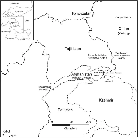
Map 1: Afghanistan’s Border with China
1
Sino-Afghani Border Relations
Artemy M. Kalinovsky
The People’s Republic of China (hereafter PRC) and the Islamic Republic of Afghanistan share a short, undisputed 40 mile (57 km) border. It is located in Afghanistan’s Northeast, on the frontier of an area known as the “Wakhan corridor” or “panhandle.” On the Chinese side of the border is Tashkurgan Tajik Autonomous County, part of Kashgar district in the province of Xinjiang. Depending on your perspective, the corridor resembles a limb or branch extending from Badakshan Province into East Asia. The Sino-Afghan border was delimited in a secret treaty signed during November 1963.
The corridor shares a border with Pakistan to its south and Tajikistan to its north. The border follows the crestline of the Little Pamir mountains, then continues across the Wakhir River Valley, and its southern section runs along the mountain crestline of Murkushi.1 The Wakhan corridor historically represented a portion of the Silk Road. Although the more important routes passed north or south of the corridor, the Wakhir Pass did serve to connect Afghanistan with China. Traders from Badakshan and elsewhere in northern Afghanistan took items such as cumin seed, furs, pelts, and spices to Kashgar, bringing back carpets, chinaware, silks and cotton material, utensils, and other goods. The significance of the route declined with the opening of sea routes between Europe and China, but local trade continued well into the 20th century.
The Wakhan corridor has a small population of some 9,000 Wakhis, who practice agriculture in the valleys, and 2,000 Kyrgyz pastoralists, who move with their flocks at higher elevations. The Wakhi, who refer to themselves as Khik, are Shiite Ismailis; the Kyrgyz are Sunni Muslims. The Wakhi language (khik zik) is an eastern Iranian language related to Tajik, and still does not exist in a written form, though various phonetic notation systems have been created. The Wakhi and Kyrgyz rarely acted as traders, although they were hired by merchants passing through the area; Uyghur traders also sold goods required by the Wakhi and Kyrgyz. The Kyrgyz apparently were more active traders than the Wakhi, and thus served as intermediaries for them. Trade through the area also served as a main source of revenue for the Mir of Wakhan, prior to the area’s absorption into Afghanistan.2 Overall there are some 50,000 Wakhis living in Xinjiang, Tajikistan, Afghanistan, and Pakistan.3 Roughly the same number of Kyrgyz live in the area, although they are very much the minority within the Wakhan corridor itself.
The Making of the Sino-Afghan Political Borders
The Sino-Afghan boundary, as well as the creation of the Wakhan corridor itself, is a 19th century product of the Great Game. British contacts with Afghanistan dated from the late 1830s, when the Afghan kings appealed to the British and Russians for help in extending their control and fending off Persian and Sikh advances. Afghanistan’s foreign policy was increasingly defined by this Anglo-Russian rivalry. It was Russia’s expansion in Central Asia that most concerned the British, and only timely and careful diplomacy helped avoid a clash between the countries. A series of diplomatic agreements were used to contain the ambitions of both sides, but parts of the frontier, still poorly mapped and even less well understood, remained contested. By the early 1890s, Russian-British rivalry and diplomacy focused on the Pamir region.
The first attempt to delimit the borders in the area was an agreement reached in 1873; this established the Amu Darya River as the dividing line between Russian and British spheres of influence. From the conquest of Khokand in 1875–1876, Russian exploration pushed into the Pamirs. Rumors of Russian designs on Wakhan in 1891 led to new worries on the part of the British and a flurry of activity to secure the area as part of the Afghanistan buffer. First, however, Amir Abdur Rahman had to be convinced to take on the responsibility of governing the territory in question. In 1893, Sir Mortimer Durand came to Kabul to discuss Afghanistan’s northern boundaries in preparation for British talks with Russia. The Amir was far from enthusiastic about adding new territory to his realm. It was too remote, too difficult to govern, and could prove too tempting to all three of the empires in the vicinity. Durand recorded that “he [the Amir] says he had a hand cut off at Somatash the other day, and he is not going to stretch out a long arm along the Hindu Kush to have that shorn off also.”4 Finally, he was persuaded to add Wakhan to his realm and awarded 5,000 pounds a year to help pay for its administration.5
Although this agreement extended Russia’s territory, it was also important for the British, since it created a boundary and a buffer between their empire and Imperial Russia. In the late summer of 1895, the British team on the Pamir Boundary Commission, assigned to demarcate the border between Afghanistan and Russia, left their camp and proceeded east toward Chinese territory. The British officials had been unable to reach an agreement with their Russian counterparts, and while both sides consulted their respective governments, the British party decided to move out on its own. At the beginning of September they returned to their camp, where they learned that the British government had decided to accept the proposed Russian line. But complete demarcation was impossible. The Russian team had placed its last pillar on the Sarikol range but could go no further; the “Durand Line,” agreed to two years previously and delimiting the border between Afghanistan and British India, was some 23 miles to the south, and 15 miles to the east was a Chinese outpost. The British team wrote in their report: “Here, amidst a solitary wilderness 20,000 feet above sea level, absolutely inaccessible to man and within the ken of no living creatures except the Pamir eagles, the three great Empires actually meet. No more fitting trijunction could possibly be found.”6
China had briefly taken control of the Pamirs during the Tang dynasty and again in the 18th century, but its 20th-century claims stem mostly from 19th-century conflicts. During the late 1860s, Yakub Beg, an adventurer from Khokand who established a kingdom centered in Kashgar, extended his influence into the Pamirs; the Mir of Wakhan fought as part of Beg’s forces. After the Qing government pacified the region, the Chinese insisted that those lands that had belonged to Yakub Beg were now legally part of China. The British at first tried to convince the Chinese to extend a corridor through the Pamirs up to Yashil Kul, thus bordering Afghanistan and creating a buffer separating British interests from Russia. But the Chinese remained uninterested in such proposals, understandably concerned that occupation of indefensible territory could simply lead to clashes with Russia.7
While the drawing of the Durand Line and the outlines of the Wakhan corridor had limited effects on the ethnic groups living in this area, the Russian revolutions in 1917, and later developments in China, greatly restricted both their mobility and trade. Some 250 Kyrgyz households had migrated to the area in the wake of the Russian revolution and the consolidation of Soviet power in Central Asia, and many more Kyrgyz and Kazakhs moved to Chinese Turkestan. Well into the 1930s the Kyrgyz were allowed to migrate back and forth across the Soviet borders in exchange for a pasturage fee of “one animal for every ten of the same type.” In the 1930s the border was closed, however, and the Kyrgyz were no longer able to move to Soviet territory; in addition, Soviet forces reportedly raided Kyrgyz camps on a number of occasions in the 1930s and early 1941, taking livestock, personal possessions, and prisoners.8 After 1949 the Chinese closed their border with Afghanistan as well, and China’s near isolation continued for the first two decades of the Cold War.
The Sino-Afghan Border in the Cold War
Sino-Afghan relations in the decades after the 1949 Chinese revolution developed in the shadow of the growing Sino-Soviet split and China’s increasingly close relationship with Pakistan and its rivalry with India. Afghanistan was not a top priority for China, but it was arguably more important to Pakistan and the Soviet Union. Thus, while China provided interest free loans, advisers, and aid to Afghanistan in the 1960s and 1970s, its support paled by comparison with that of the Soviet Union or even the United States. However, China’s involvement did help draw some Afghan intellectuals to Maoism, leading to the creation of a Maoist organization, which later spawned splinter organizations and heavily influenced the student union at Kabul University.9 The actual importance of these groups in Afghan politics was probably less than the paranoia they caused among Soviet officials, as evidenced by dispatches from the Kabul embassy.10
Due to these Cold War tensions, it was not until 1963 that China and Afghanistan formally agreed to demarcate their mutual border. Afghanistan had recognized the PRC during January 1950, but formal diplomatic relations were not established until 1955. China and Afghanistan announced their decision to negotiate a “boundary existing between their two countries” on 2 March 1963, and a secret boundary agreement was signed in November of that year. Although it was never stated publicly, the agreement effectively confirmed the boundary existing as a result of the Russian-British negotiations. A joint boundary commission went to work the next year to demarcate the border.11
Sino-Afghan relations remained rocky. Beijing was suspicious of the pro-Soviet communists that came to power after the Saur revolution in 1978, and, not surprisingly, was highly critical of the Soviet intervention in December 1979. In its wake, the Soviet ambassador in Beijing was told that “Afghanistan is China’s neighbour … and therefore the Soviet armed invasion of that country poses a threat to China’s security. This cannot but arouse the grave concern of the Chinese people.”12 Chinese leaders viewed the Afghan intervention as part of more general encirclement by the Soviet Union and its allies. The USSR’s 1979 action took place soon after the end of the PRC’s short war with Vietnam, only recently a Chinese ally but at that time tilting heavily toward the Soviet Union. The Soviet presence in Afghanistan was part of a more broadly menacing policy, with Deng Xiaoping stating: “In seeking hegemony against China, the Soviet Union had not only stationed 1,000,000 troops along the Sino-Soviet border, but had dispatched troops to invade Afghanistan.”13
Although Afghanistan’s short border with China was not particularly important in and of itself, the Wakhan corridor was critical, since it bordered Pakistan to the south and the USSR to the north. With Pakistan the single most important ...
Table of contents
- Cover
- Half Title
- Title Page
- Copyright Page
- Dedication
- Table of Contents
- Acknowledgments
- Series Editor's Preface
- Abbreviations
- List of Maps
- Introduction
- 1. Sino-Afghani Border Relations
- 2. Bhutan-China Border Disputes and Their Geopolitical Implications
- 3. Brunei's Contested Sea Border with China
- 4. India's Intractable Border Dispute with China
- 5. Indonesia's “Invisible” Border with China
- 6. Sino-Japanese Territorial and Maritime Disputes
- 7. Kazakhstan's Border Relations with China
- 8. Sino-Korean Border Relations
- 9. Kyrgyzstan: China's Regional Playground?
- 10. The China-Laos Boundary: Lan Xang Meets the Middle Kingdom
- 11. Malaysia and China: Economic Growth Overshadows Sovereignty Dispute
- 12. Sino-Mongol Border: From Conflict to Precarious Resolution
- 13. The Sino-Myanmar Border
- 14. China-Nepal Border: Potential Hot Spot?
- 15. The Sino-Pakistan Border: Stability in an Unstable Region
- 16. Philippine-China Border Relations: Cautious Engagement Amid Tensions
- 17. Sino-Russian Border Resolution
- 18. PRC Disputes with the ROC on Taiwan
- 19. Tajikistan-China Border Normalization
- 20. Sino-Vietnamese Border Disputes
- Conclusions
- Selected Bibliography
- Index
- About the Editors and Contributors
Frequently asked questions
Yes, you can cancel anytime from the Subscription tab in your account settings on the Perlego website. Your subscription will stay active until the end of your current billing period. Learn how to cancel your subscription
No, books cannot be downloaded as external files, such as PDFs, for use outside of Perlego. However, you can download books within the Perlego app for offline reading on mobile or tablet. Learn how to download books offline
Perlego offers two plans: Essential and Complete
- Essential is ideal for learners and professionals who enjoy exploring a wide range of subjects. Access the Essential Library with 800,000+ trusted titles and best-sellers across business, personal growth, and the humanities. Includes unlimited reading time and Standard Read Aloud voice.
- Complete: Perfect for advanced learners and researchers needing full, unrestricted access. Unlock 1.5M+ books across hundreds of subjects, including academic and specialized titles. The Complete Plan also includes advanced features like Premium Read Aloud and Research Assistant.
We are an online textbook subscription service, where you can get access to an entire online library for less than the price of a single book per month. With over 1.5 million books across 990+ topics, we’ve got you covered! Learn about our mission
Look out for the read-aloud symbol on your next book to see if you can listen to it. The read-aloud tool reads text aloud for you, highlighting the text as it is being read. You can pause it, speed it up and slow it down. Learn more about Read Aloud
Yes! You can use the Perlego app on both iOS and Android devices to read anytime, anywhere — even offline. Perfect for commutes or when you’re on the go.
Please note we cannot support devices running on iOS 13 and Android 7 or earlier. Learn more about using the app
Please note we cannot support devices running on iOS 13 and Android 7 or earlier. Learn more about using the app
Yes, you can access Beijing's Power and China's Borders by Bruce Elleman,Stephen Kotkin,Clive Schofield in PDF and/or ePUB format, as well as other popular books in Politik & Internationale Beziehungen & Chinesische Geschichte. We have over 1.5 million books available in our catalogue for you to explore.