1
INTRODUCTION
The term fluvial is derived from the Latin fluvius, meaning river. Fluvial geomorphology is the study of the interactions between river channel forms and processes at a range of space and time scales. The influence of past events is also significant in explaining the present form of river channels. Rivers are found in many different environments and show an amazing diversity of form. In this chapter you will learn about:
- The different scales at which rivers are examined.
- How the form of a river channel is determined by the balance between the physical force acting on the material forming the channel and the resistance of that material to being moved.
- The way in which local environmental factors interact with these hydraulic forces to produce a wide variety of channel forms.
DIVERSITY OF FORM
A quick look through the photographs in this book will give you some idea of the variety that can be seen in rivers and streams worldwide. Rivers drain much of the land area – with the exception of regions that are hyper-arid or permanently frozen – and their variety reflects the vast range of different environments in which they are found. Climate, geology, vegetation cover and topography are just some of the factors that influence river systems.
Rivers are found in many different climatic zones, ranging from humid to arid, and from equatorial to arctic. Some of the larger rivers even flow across different climatic zones, originating in a humid area before flowing through an arid region. Examples of these ‘exotic’ rivers include the Nile and Colorado, both of which sustain agriculture and urban centres in desert regions. Perennial rivers flow for all or most of the year, while many of those in dryland environments only transmit water at certain times. The ‘trail’ shown in Colour Plate 1 is actually an ephemeral channel that was photographed in South Africa during the winter dry season. A small herd of cattle in the distance provide an idea of scale.
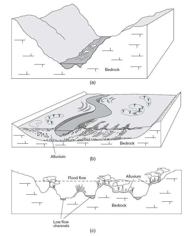
The material in which the channel is formed is called the channel substrate. An important distinction can be made between bedrock and alluvial substrates (Figure 1.1). Bedrock channels, as their name suggests, are sections of channel that are cut directly into the underlying bedrock, while alluvial channels are formed in alluvium – sediment that has previously been laid down in the valley floor by rivers. Alluvium can include a mixture of unconsolidated particles ranging in size from boulders, gravels and sands to finer deposits of silts and clays. Where the valley floor is wide enough, material laid down in the channel, together with silt deposited by floods, form a floodplain adjacent to the river channel (Figure 1.1b). The ephemeral channel shown in Colour Plate 1 is formed in alluvium. Colour Plate 2 shows an example of a bedrock channel, while Colour Plate 3 shows a mixed channel which has a rock bed and alluvial banks.
Figure 1.1 (a) Bedrock channels are cut directly into the underlying bedrock. (b) Alluvial channels are formed in alluvial deposits that have been deposited on the valley floor by fluvial processes. (c) Rivers exist on a continuum from bedrock to alluvial and there are also many mixed alluvial/bedrock channels. This is just one example, showing a cross-section of a mixed channel reach. Bars separate the flow into multiple channels. Each bar has a bedrock core, which is overlain by vegetated alluvial deposits. (c) adapted from van Niekirk et al. (1999).
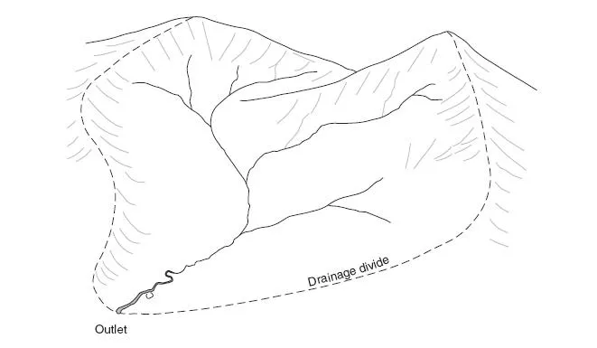
Most rivers flow to the oceans, although some drain to inland seas and lakes, while others dry up completely before reaching the ocean. Each river drains an area of land called its drainage basin – also known as its catchment or watershed – which supplies water and sediment to the channel (see Figure 1.2). This area is bounded by a drainage divide or catchment boundary, something that is clearly visible as a ridge in mountainous areas but which can be rather difficult to discern in areas of more subdued topography. The outlet, where the main channel exits the basin, is at a lower elevation than the rest of the basin area. Drainage basins form a mosaic across the land surface, varying greatly in size from a few hectares to millions of square kilometres.
Within each drainage basin is a branching network of channels. The main, or trunk, channel is fed by numerous small tributaries which join to form progressively larger channels. Drainage patterns, as viewed from the air or on maps, vary considerably between basins. The development and evolution of drainage networks is influenced by a number of factors, including geology, climate and long-term drainage basin history. Further information on the ways in which structural controls influence drainage patterns can be found in Box 1.1.
In terms of the actual form of different channels, obvious differences can be seen, even along the same river. One of the more noticeable things is the variation in size, from tiny headwater streams that are just a few centimetres wide to large rivers several hundred metres or more in width. The size of a river channel at a given point is largely determined by the discharge supplied from upstream. This is the volume of water that passes through a given channel cross-section in a given period of time. In the upper reaches of a river, the area drained – and hence the discharge – is relatively small. As you move downstream, discharge and channel size generally increase with the upstream drainage area.
While many rivers follow a single channel, there are also numerous examples of rivers with multiple channels. Those that flow in a single channel usually tend to deviate from a straight line, sometimes following rather an irregular path, in other cases forming more regular meanders (Colour Plates 4 and 5). Braided channels are characterised by numerous bars and islands formed by sediment deposits in the channel (Colour Plates 6 and 7). A rather different type of multiple channel are the anabranching channels shown in Colour Plates 8 and 9. Rather than being separated by bars, the individual channels are cut into the floodplain itself.
Figure 1.2 The drainage basin is the area of land drained by each river.
Box 1.1
DRAINAGE NETWORK PATTERNS
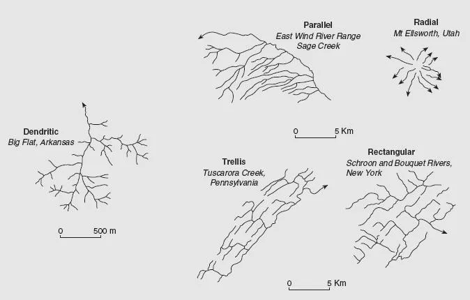
Water and sediment are transported from the hillslopes to the basin outlet via the drainage network. The shape and density (length of stream channel per unit area) of drainage networks varies considerably, and no two are the same. Figure 1 provides some typical examples of selected drainage patterns. A major control on drainage network morphology is the underlying geology, although topography, soils, tectonic history and climate are also influential. Dendritic drainage networks, which have a random pattern, are found where there are no strong geological controls. Where there is a strong regional dip (slope), parallel drainage patterns develop. Trellis networks are also associated with regional dip, although in this case structural controls are also important; for example, where lines of weakness are provided by well developed joints running at right angles to the dip. Where two sets of structural controls run at right angles to each other, a rectangular pattern develops. Trellis and rectangular networks may also be found where there are alternating bands of hard and soft strata. Radial drainage develops as result of symmetrical erosion around uplifted domes and volcanoes. Although drainage patterns are used in the interpretations of tectonic influences and underlying structural controls, there may not always be a close correspondence. During their long term history, rivers cut down through great thickness of rock, and former drainage patterns are sometimes preserved.
Figure 1 Basic drainage patterns. Adapted from Morisawa (1985).
When considering channel form, individual sections, or reaches, of channel are usually considered. This is because of the downstream changes in channel size and shape that are brought about by factors such as increasing drainage area and variations in channel substrate. As a result, different channel patterns may be found along the same channel. At the reach scale – typically a few tens to hundreds of metres or more – there is a homogeneity of form.
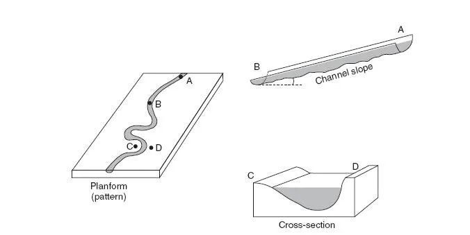
Rivers are three-dimensional in shape and, in addition to the channel planform patterns described above, variations are also seen in cross-sectional shape and channel slope (Figure 1.3). For example, braided channels tend to be relatively wide and shallow in comparison to meandering channels, which have a narrower, deeper cross-section. Headwater streams in mountainous areas typically flow in steep channels, with frequent waterfalls, pools and rapids. This is in contrast to rivers that flow across lowland floodplains, where the channel slope is much more gentle.
Fluvial forms also exist at the sub-channel scale. These include channel bars, pools excavated by localised scour, and periodic features such as dunes and ripples that form on the bed of sandy channels. You will see later in the book how certain groupings, or assemblages, of these features are associated with different channel types.
HOW RIVERS SHAPE THEIR
CHANNELS
Rivers and streams continuously shape and reform their channels through erosion of the channel boundary (bed and banks) and the reworking and deposition of sediments. For example, erosion and undermining of the banks can lead to channel widening. Scouring of the channel bed deepens the channel, while sediment deposition reduces the depth and can lead to the formation of channel bars. These are just some of the ways in which channel adjustment takes place.
Figure 1.3 Elements of three-dimensional channel form. The planform is the shape of the river viewed from above, the channel slope is shown for the reach between points A and B, and the channel cross-section between C and D.
There is an important balance between the erosive power of the flow and the strength, or resistance, of the bed and bank material to erosion. During major flood events, when the erosive power of the flow is greatly increased, there can be dramatic changes in channel form. Just how dramatic these changes are depends on how much resistance is provided by the bed and banks. Channels formed in unconsolidated alluvium offer much less resistance to erosion than those cut in bedrock. In fact, most flows are able to shape channels formed in sandy alluvium because relatively little energy is required to set the individual sand grains in motion. Because silts and clays are smaller than sand grains, you might expect these particles to be easier to erode. However, they tend to stick together as a result of cohesive (attractive) electrochemical forces between the particles. This means that channel boundaries with a high proportion of silt and clay are actually more resistant to erosion than those formed in sand and fine gravel. The amount and type of vegetation growing along the banks is also significant, since this can provide additional resistance to erosion.
In many cases, it is only extreme floods that are capable of significantly modifying bedrock channels. The comparative rarity of these very large floods means that channel adjustments tend to occur sporadically, being interspersed by long periods of little change. Alluvial channels dominated by ...