- 356 pages
- English
- ePUB (mobile friendly)
- Available on iOS & Android
eBook - ePub
About this book
The Thames Gateway plan is the largest and most complex project of urban regeneration ever undertaken in the United Kingdom. This book provides a comprehensive overview and critique of the Thames Gateway plan, but at the same time it uses the plan as a lens through which to look at a series of important questions of social theory, urban policy and governmental practice. It examines the impact of urban planning and demographic change on East London's material and social environment, including new forms of ethnic gentrification, the development of the eastern hinterlands, shifting patterns of migration between city and country, the role of new policies in regulating housing provision and the attempt to create new cultural hubs downriver. It also looks at issues of governance and accountability, the tension between public and private interests, and the immediate and longer term prospects for the Thames Gateway project both in relation to the 'Olympics effect' and the growth of new forms of regionalism.
Trusted by 375,005 students
Access to over 1.5 million titles for a fair monthly price.
Study more efficiently using our study tools.
Information
PART 1
Big Pictures, Small Details
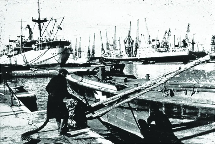
Plate 1.1 Photograph of Royal Docks 1952. Author’s photograph
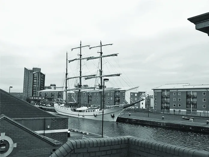
Plate 1.2 Photograph of Royal Docks 2008. Author’s photograph
Chapter 1
Ex-ports: The Laboratory Role of the London Docklands1
In port-cities all over the world docklands are the subject of radical changes and transformations, but the London Docklands area is by far the biggest, with the most extensive and radical transformations, with effects on the spatial, economic and social structure of the whole metropolitan and regional area, which even have national and international importance. Because of the enormous scale, the radical character of the transformations and wider meaning of these transformations, studying and discussing the London Docklands has a worldwide relevance. The area is a laboratory from which every port-city can learn lessons.
London as well as the Dutch port-cities can be considered as trend-setting types of port-cities over many centuries, alternating with each other in playing a leading role in the international port economy, but also in playing a leading role in the planning and design of paradigmatic relationships between port and city.
During the twentieth century, the London region and Holland became two showcases of modern urban planning: Sir Patrick Abercrombie’s Greater London Plan (1946), Cornelis van Eesteren’s Amsterdam Extension Plan of (1934) and Cor van Traa’s reconstruction plan for Rotterdam (1946) were considered as the most important examples of modern city-planning in that period. Lewis Mumford, acknowledged worldwide as an important international expert on city planning at that time, celebrated the London and Dutch experiences as setting examples for every city.2 All these typical modernistic plans demonstrated the ambition to plan and to control urban society by planning and controlling the spatial framework of the city. However, in all these plans the port was considered to be a world which it was not possible to plan and control and which should be excluded from the daily urban world.
The question of regeneration of port areas, especially in these countries most strongly influenced by modernism over many decades, puts something essential on the table concerning urban planning in general: these areas seem to have a great potential to function as the start of a another type of urban planning – not only because of the possibility of spectacular waterfronts, but especially because these areas escaped from the control of the modernistic planning machine.
The development of port-cities can be regarded as the most manifest examples of the general process of modernisation. In general, the process of modernisation concerns the development of a balance between the process of globalisation and the ambitions of local communities to improve the conditions of daily life. A second aspect of this modernisation process concerns the relation between urbanisation and the natural conditions of the territory, which should be revised in order to avoid an overly aggressive exploitation of nature, soil, water and air. These two themes are as old as the city itself, and especially as old as the port-city.
Establishing new relations between the local and global and between urbanisation and nature is important nowadays because of the scale of these developments worldwide. During the next 35 years, a 100 per cent increase of the population living in cities all over the world of is expected,3 especially in developing countries, and most of this unprecedented urbanisation will take place in coast and delta areas. The developments in China are illustrative: more than 90 per cent of the Chinese industrial economy is concentrated in the coastal zones, where 330 port-cities are taking care of the worldwide distribution of the new products of the Chinese economy; all of these 330 port-cities seem to be trying to become the largest port in the world.4 It means that all the delta-areas of this enormous country are colonised by industrial and urban developments, with tremendous effects on the quality of urban life and on the quality of the natural environment.
China is currently an extreme example of this, but similar processes are happening in other parts of Asia, in Africa and Latin-America, while port-cities and port-regions in the ‘western world’ find themselves in the process of structural reorganisation, de-industrialisation and urbanisation. More than ever, coastal zones – and especially port-cities – are the backbone of economic traffic and urban development all over the world.
These processes of exploding economic growth and intensification in port-areas are developing parallel to two other important processes:
– the increasing need for an approach to urban development which pays attention to the specific cultural and historic identity of cities and regions, related to the general desire for local communities which have a clear identity, as a counterweight to the processes of globalisation;
– the increasing need for a careful approach to the natural environment, especially the water-systems of rivers, deltas and coastal areas.
Port-cities have already played a role as laboratories of modernisation for many centuries. Port-cities represent in the most explicit and critical ways new approaches to the two above-mentioned ‘great themes’ – the relation between the global and the local, and the relation between urbanisation and the natural territory.
From the early phase of modern urban development, from the thirteenth and fourteenth centuries, until the end of the twentieth century, there have been two contrasting ways of responding to these two ‘great themes’. In earlier times too, the case of the London Docklands had an important role as a ‘trendsetter’.
The First Arrangement: The Port-City as Intermediate Zone
The first arrangement, developed in most western port-cities from the late Middle Ages until the middle of the nineteenth century, was characterised by a strong interweaving of both port and urban infrastructure and of the natural conditions of the landscape and the port infrastructure. The construction of the port infrastructure was made possible by the presence of natural artefacts such as bays, creeks, etc. The development, construction and maintenance of the port and urban infrastructure were combined in one policy. City and port were interwoven with each other; the port was located near or on the immediate border of the city. In this enclosed system of the port-city, the harbour was a marketplace – the final destination on the transportation route – and the port’s infrastructure was organised within the enclosed boundary of the city.
However, this integration of urban system and port system was effected in different ways. The difference of Dutch and British port-cities is illustrative; very similar but dealing with different local configurations of the relations between water and territory and with different relationships between public and private initiatives.
In the Dutch port-cities – the most important centres of world trade during the seventeenth century – the urban port infrastructure was a transformed and manipulated part of the landscape drainage system. The systems of harbours and canals in cities like Amsterdam and Rotterdam were developed and constructed as public works; they functioned as port infrastructure as well as drainage systems and as the primary elements of the urban fabric. This enabled merchants and port entrepreneurs to build relatively small warehouses and depots beside the canals. The elements of hydraulic engineering – canals, quays, dykes, dams and sluices – were at the same time the main framework of the urban fabric. The quays and dykes were the most important urban streets; the dam was the main square and the core of the Dutch water-city. City, port and water-management infrastructure were completely interwoven.
In London, on the contrary, a large-scale port infrastructure, initiated and constructed by public authorities, did not exist. Here special companies, such as the West India Company and the East India Company, played a main role in the development of port equipment. During the 1700s, these companies gave emphasis to the development of a new type of buildings. During this period the port of London was concentrated on the River Thames, where ships could lie in the roads and could be loaded and unloaded at the riverbanks. The integration of port and city in London was demonstrated by the scale of building, with the famous Adelphi building by Robert Adams as the most prestigious and famous exemplification of the modern port-city of mid-eighteenth-century. London had taken over the leading role as the most important trade centre of the world from Holland, and the Adelphi was the demonstration par excellence of the city that ‘ruled the waves’.
The Second Arrangement: Creating Sharp Borders
While the Adelphi represented the peak of the special relationship between city and port, at the same time it marked its end. From the end of the eighteenth century London developed a quite different type of port infrastructure, by creating a brand new landscape of docklands. The dock was an innovative invention, which enabled mass ship-handling, protected against the tidal movement of the water, (which is rather extreme in London) and protected against robbery and raids, which was an established tradition on the open and unprotected water of the River Thames. The initiative, lay-out and construction of the docks was the result of initiatives by the companies, who originally owned and ruled these docks.
The moving of the port activities from the riverbanks to the new docks resulted in a sharp separation between city and port, which would deeply influence the spatial development of other western port-cities.
In many port-cities, it took a long time – from the middle of the nineteenth century to the beginning of the twentieth century – for the development of a totally different relationship between port and city to take place. During the nineteenth century there was a great deal of construction of new large-scale public works of basins, quays and warehouses – designed and constructed by professional departments of public works, which also were responsible for the extension of the city and the water-management of the city – in many continental port-cities, for instance, in Holland. On the other hand, the first signs of specialisation and autonomous development of the port as an independent entity also became visible in the continental port-cities. From the 1920s and 1930s a new, modernistic arrangement of port-city relations was developed that finally departed radically from the original arrangement. Planning institutions became convinced that it was no longer fruitful to combine the scale of the port with the development of the city. An inspiring example for this new separation was the case of the London Docklands.
The London Docklands also became a showcase of something which other cities tried to avoid: the destiny of the leftover land between the docks as residential areas for the poorest people of the city. This London East End was made famous by Charles Dickens’ novels, which described the poor and miserable conditions of the people in this zone, most of them dependent on employment in the port. The separation of city and port became part of a social policy, intended to insulate the urban community from the raw and strange world of the ships and the port.
During the post-World War II decades, the separation of port and city was concluded. Rotterdam, the world’s largest port from 1961, built its new port and industrial complexes even further away from the city. In many cases, clear distinctions – in terms of both policy and space – were made between the industrialised port landscape, the city and the green landscape.
Port and urban planning came off worse in processes which were dominated by a conceptual separation between urban social values and large-scale infrastructures. The large technical framework of the large-scale infrastructure, including the port infrastructure, was regarded as being in conflict with the social, public domain of the city.
The Twenty-first Century: Towards a Third Arrangement of Port-City Landscape
As a result of the policy of concentrating all port activities outside the urban territory, many old dockland areas constructed in the eighteenth and nineteenth centuries lost their original function and instead became key targets of policies of urban regeneration in most European and North-American port-cities. Such famous examples as Baltimore’s Inner Harbour, New York’s Battery Park City, Barcelona’s Moll de la Fusta and Rotterdam’s Kop van Zuid established a new orientation of the city on the water, and created an urban waterfront which could play a major role in the economic and social regeneration of the whole city.
At first sight, the redevelopment of the London Docklands seemed to be part of this international series of urban regeneration projects. The big differences seem to be the scale and the more or less autonomous position of the London Docklands Development Corporation, which was allowed to follow a development policy which did not have to take much account of the interests of the surrounding communities. However, not only is the regeneration of docklands a larger development than other examples of its kind, but its scale also creates the possibility that Docklands might become the forerunner of a comprehensive planning policy in large-scale delta areas.
At the time of writing, the situation of the urban water edges is changing. The port and transport economy and technology are undergoing fundamental changes. Some port activities need more large-scale concentration, deep water, etc.; other port and transport activities need greater decentralisation combined with an effective logistic organisation. Modern ports no longer have the linear c...
Table of contents
- Cover Page
- London’s Turning
- Copyright Page
- Contents
- List of Figures, Plates and Tables
- List of Contributors
- Preface and Acknowledgements
- Editorial Introduction
- PART 1: BIG PICTURES, SMALL DETAILS
- PART 2: CASE STUDIES IN URBAN CHANGE
- Index
Frequently asked questions
Yes, you can cancel anytime from the Subscription tab in your account settings on the Perlego website. Your subscription will stay active until the end of your current billing period. Learn how to cancel your subscription
No, books cannot be downloaded as external files, such as PDFs, for use outside of Perlego. However, you can download books within the Perlego app for offline reading on mobile or tablet. Learn how to download books offline
Perlego offers two plans: Essential and Complete
- Essential is ideal for learners and professionals who enjoy exploring a wide range of subjects. Access the Essential Library with 800,000+ trusted titles and best-sellers across business, personal growth, and the humanities. Includes unlimited reading time and Standard Read Aloud voice.
- Complete: Perfect for advanced learners and researchers needing full, unrestricted access. Unlock 1.5M+ books across hundreds of subjects, including academic and specialized titles. The Complete Plan also includes advanced features like Premium Read Aloud and Research Assistant.
We are an online textbook subscription service, where you can get access to an entire online library for less than the price of a single book per month. With over 1.5 million books across 990+ topics, we’ve got you covered! Learn about our mission
Look out for the read-aloud symbol on your next book to see if you can listen to it. The read-aloud tool reads text aloud for you, highlighting the text as it is being read. You can pause it, speed it up and slow it down. Learn more about Read Aloud
Yes! You can use the Perlego app on both iOS and Android devices to read anytime, anywhere — even offline. Perfect for commutes or when you’re on the go.
Please note we cannot support devices running on iOS 13 and Android 7 or earlier. Learn more about using the app
Please note we cannot support devices running on iOS 13 and Android 7 or earlier. Learn more about using the app
Yes, you can access London's Turning by Michael J. Rustin, Philip Cohen in PDF and/or ePUB format, as well as other popular books in Politics & International Relations & Local & Regional Planning Public Policy. We have over 1.5 million books available in our catalogue for you to explore.