![]()
Chapter 1
Departure Procedures
Introduction
Thousands of instrument flight rules (IFR) takeoffs and departures occur daily in the National Airspace System (NAS). In order to accommodate this volume of IFR traffic, air traffic control (ATC) must rely on pilots to use charted airport sketches and diagrams, as well as departure procedures (DPs) that include both standard instrument departures (SIDs) and obstacle departure procedures (ODPs). While many charted (and uncharted) departures are based on radar vectors, the bulk of IFR departures in the NAS require pilots to navigate out of the terminal environment to the en route phase.
IFR takeoffs and departures are fast-paced phases of flight, and pilots often are overloaded with critical flight information. While preparing for takeoff, pilots are busy requesting and receiving clearances, preparing their aircraft for departure, and taxiing to the active runway. During IFR conditions, they are doing this with minimal visibility, and they may be without constant radio communication if flying out of a non-towered airport. Historically, takeoff minimums for commercial operations have been successively reduced through a combination of improved signage, runway markings and lighting aids, and concentrated pilot training and qualifications. Today at major terminals, some commercial operators with appropriate equipment, pilot qualifications, and approved Operations Specifications (OpSpecs) may takeoff with visibility as low as 300 feet runway visual range (RVR). One of the consequences of takeoffs with reduced visibility is that pilots are challenged in maintaining situational awareness during taxi operations.
Surface Movement Safety
One of the biggest safety concerns in aviation is the surface movement accident. As a direct result, the FAA has rapidly expanded the information available to pilots, including the addition of taxiway and runway information in FAA publications, particularly the IFR U.S. Terminal Procedures Publication (TPP) booklets and the Chart Supplement (CS) volumes. The FAA has also implemented new procedures and created educational and awareness programs for pilots, ATC, and ground operators. By focusing resources to attack this problem head on, the FAA hopes to reduce and eventually eliminate surface movement accidents.
Airport Sketches and Diagrams
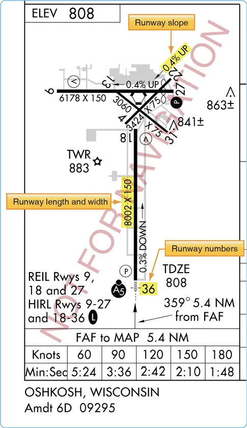
Airport sketches and diagrams provide pilots of all levels with graphical depictions of the airport layout. Aeronautical Information Services, formerly known as Aeronautical Products (AeroNav), provide an airport sketch on the lower left or right portion of every instrument approach chart. [Figure 1-1] This sketch depicts the runways, their length, width and slope, the touchdown zone elevation, the lighting system installed on the end of the runway, and taxiways. Graphical depictions of NOTAMS are also available for selected airports as well as for temporary flight restriction (TFRs) areas on the defense internet NOTAM service (DINS) website.
Figure 1-1. Airport diagram included on the Oshkosh, Wisconsin VOR RWY 9 Approach Chart as depicted in the IFR TPP.
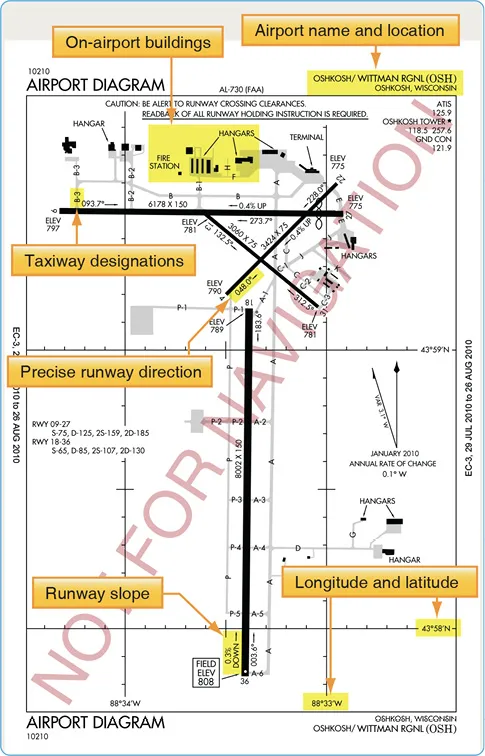
For select airports, typically those with heavy traffic or complex runway layouts, Aeronautical Information Services also prints an airport diagram. The diagram is located in the IFR TPP booklet following the instrument approach chart for a particular airport. It is a full page depiction of the airport that includes the same features of the airport sketch plus additional details, such as taxiway identifiers, airport latitude and longitude, and building identification. The airport diagrams are also available in the Airport/Facility Directory section of the Chart Supplement (CS) and on the Aeronautical Information Services’ website, located at www.aeronav.faa.gov. [Figure 1-2]
Figure 1-2. Airport diagram of Oshkosh, Wisconsin as depicted in the A/FD section of the CS.
Chart Supplements (CS)
In recent years, the former Airport/Facility Directory (A/FD) booklet was incorporated as a section in the Chart Supplement (CS). [Figure 2-14] The Chart Supplement (CS) is published by Aeronautical Information Services in regional booklets and online at: [https://www.faa.gov/air_traffic/flight_info/aeronav/digital_products/dafd/] The online version is known as the digital Chart Supplement (d-CS). The d-CS and the CS are identical and provide textual and graphic information about all airports, both Visual Flight Rules (VFR) and IFR. The Airport/Facility Directory (A/FD) section of the CS includes runway length and width, runway surface, load bearing capacity, runway slope, runway declared distances, airport services, and hazards, such as birds and reduced visibility. [Figure 1-3] Sketches of airports also are being added to aid VFR pilots in surface movement activities. In support of the FAA Runway Incursion Program, full page airport diagrams and “Hot Spot” locations are included in the A/FD section of the CS. These charts are the same as those published in the IFR TPP and are printed for airports with complex runway or taxiway layouts.
Figure 1-3. Excerpts from the Chart Supplement (Airport Facility Directory section) of Naples Muni, Naples, Florida.
Surface Movement Guidance Control System (SMGCS)
The Surface Movement Guidance Control System (SMGCS) was developed to facilitate the safe movement of aircraft and vehicles at airports where scheduled air carriers were conducting authorized operations. Advisory Circular 120-57 was developed in 1992. In 2012, FAA Order 8000.94, Procedures for Establishing Airport Low-Visibility Operations and Approval of Low-Visibility Operations/Surface Movement Guidance and Control System Operations, was published to provide procedures for establishing Airport Low-Visibility Operations (LVO) and Surface Movement Guidance and Control Systems. It established the necessary FAA headquarters and operating services, roles, responsibilities, and activities for operations at 14 CFR Part 139 airports using RVRs of less than 1,200 feet for each runway. The order applies to all users of the system at all levels who are formally listed. The FAA requires the commissioning of an “FAA approved LVO/SMGCS Operation” for all new Category III ILS supported runways. Since there are no regulatory takeoff minimums for 14 CFR Part 91 operations, the information provided by FAA AC 120-57 and FAA Order 8000.94 must be understood so that the general aviation pilot can understand LVO and SMGCS during day or night.
The SMGCS low visibility taxi plan includes the enhancement of taxiway and runway signs, markings, and lighting, as well as the creation of SMGCS visual aid diagrams. [Figure 1-4] The plan also clearly identifies taxi routes and their supporting facilities and equipment. Airport enhancements that are part of the SMGCS program include, but are not limited to:
• Controllable Stop bars lights—these consist of a row of red, unidirectional, in-pavement lights that can be controlled by ATC. They provide interactions with and aircraft that prevent runway incursions during takeoff operations. These are required for operations at less than 500 ft RVR.
• Non-Controllable Stop bars lights—these are red, unidirectinoal lights place at intersections where a restriction to movement is required. They must be in continuous operation at less than 500 ft RVR.
• Taxiway centerline lead-on lights—guide ground traffic under low visibility conditions and at night. These lights consist of alternating green/yellow inpavement lights.
• Runway guard lights—either elevated or inpavement, may be installed at all taxiways that provide access to an active runway. They consist of alternately flashing yellow lights. These lights are used to denote both the presence of an active runway and identify the location of a runway holding position marking.
• Geographic position markings—ATC verifies the position of aircraft and vehicles using geographic position markings. The markings can be used either as hold points or for position reporting. These checkpoints or “pink spots” are outlined with a black and white circle and designated with a number or a number and a letter.
...