The goal of How to Make Maps is to equip readers with the foundational knowledge of concepts they need to conceive, design, and produce maps in a legible, clear, and coherent manner, drawing from both classical and modern theory in cartography.
This book is appropriate for graduate and undergraduate students who are beginning a course of study in geospatial sciences or who wish to begin producing their own maps. While the book assumes no a priori knowledge or experience with geospatial software, it may also serve GIS analysts and technicians who wish to explore the principles of cartographic design.
The first part of the book explores the key decisions behind every map, with the aim of providing the reader with a solid foundation in fundamental cartography concepts. Chapters 1 through 3 review foundational mapping concepts and some of the decisions that are a part of every map. This is followed by a discussion of the guiding principles of cartographic design in Chapter 4—how to start thinking about putting a map together in an effective and legible form. Chapter 5 covers map projections, the process of converting the curved earth's surface into a flat representation appropriate for mapping. Chapters 6 and 7 discuss the use of text and color, respectively. Chapter 8 reviews trends in modern cartography to summarize some of the ways the discipline is changing due to new forms of cartographic media that include 3D representations, animated cartography, and mobile cartography. Chapter 9 provides a literature review of the scholarship in cartography. The final component of the book shifts to applied, technical concepts important to cartographic production, covering data quality concepts and the acquisition of geospatial data sources (Chapter 10), and an overview of software applications particularly relevant to modern cartography production: GIS and graphics software (Chapter 11). Chapter 12 concludes the book with examples of real-world cartography projects, discussing the planning, data collection, and design process that lead to the final map products.
This book aspires to introduce readers to the foundational concepts—both theoretical and applied—they need to start the actual work of making maps. The accompanying website offers hands-on exercises to guide readers through the production of a map—from conception through to the final version—as well as PowerPoint slides that accompany the text.
Trusted by 375,005 students
Access to over 1.5 million titles for a fair monthly price.
Maps enable us to view our world in terms of space—how we are situated in space, and how the features of the earth’s surface fit together. As you start reading this book on the topic of maps and how to make them, take a moment to consider the critical role that maps have played throughout the development of human history and society. It is difficult to imagine the world today without them; maps enabled people to effectively navigate across space and explore the surface of the earth. Maps are powerful: they played a critical role in the conquest and establishment of territory, and then in the governance of that territory. The formal organization of space through maps both caused and prevented conflict throughout history. Maps occasionally influence events in quite overt ways, such as in 2010, when errors in mapping led to troops from Nicaragua to accidentally “invade” neighboring Costa Rica (Brown 2010).
These days, people read maps on a regular basis without much thought. City maps, hiking maps, weather maps, road or subway maps, maps of countries or conflicts, and maps on countless thematic topics have become part of the fabric of daily life. With the rise of mobile phone technology and global positioning systems (GPS), we how have dynamic maps that seem to magically show where we are in real time, almost as if it were taken straight out of a Harry Potter novel.
The word “map” appears to be derived from the Latin word mappa, which means “sheet” or “cloth,” a root word that can be found in other modern English words such as “apron” or “napkin” (Ayto 2011, 337). It is significant that the very origins of the word encapsulate the two-dimensional nature of a map, salient to those who work in cartography. The Oxford English Dictionary (Stevenson 2010) identifies the first use of the word “map” in the English language in the sixteenth century. The word is defined as:
A drawing or other representation of the earth’s surface or a part of it made on a flat surface, showing the distribution of physical or geographical features (and often also including socio-economic, political, agricultural, meteorological, etc., information), with each point in the representation corresponding to an actual geographical position according to a fixed scale or projection; a similar representation of the positions of stars in the sky, the surface of a planet, or the like. Also: a plan of the form or layout of something, as a route, a building, etc.
There are some important components to this definition. A photograph or image of the earth’s surface is not really a map, because it is not “a drawing or representation” and does not involve symbols. While the term “map” is used interchangeably for a variety of other disciplines and purposes—such as mapping the human genome or the galaxy—cartography has traditionally focused on mapping the earth’s surface, and so here we rely on that traditional definition. A more succinct but sufficient definition from the Oxford English Dictionary’s website is “A diagrammatic representation of an area of land or sea showing physical features, cities, roads, etc.” (Oxford English Dictionary 2018).
Maps offer enormous analytical power. A map can be thought of as a “macroscope” that enables the reader to visualize, explore, and analyze patterns that are otherwise invisible to the naked eye. As microscopes enabled significant advances in biology by making visible entities that were otherwise impossible to see—cells, bacteria, viruses, and the like—so have maps enabled advances in geography and other fields by enabling us to view patterns across vast areas of the earth, equally impossible to “see” with the naked eye. Maps have ultimately led to revolutionary advances in our understanding of regional- and global-scale processes.
Because of the diversity of ways in which maps are used in contemporary society, they have become an extremely important and powerful tool associated with a broad range of related technologies that facilitate the collection, management, and analysis of spatial data. Consequently, the art, science, and practice of cartography, that is, the design and production of maps, has become a critical skill for many twenty-first-century professionals.
The purpose of this book is to provide you with the background, knowledge, and critical skills for practicing cartography effectively and efficiently. The goal is to equip you with the ideas and concepts you need to conceive, design, and produce maps, drawing from both classical and modern theory in cartography. The principles of cartographic design will be given rigorous treatment, beginning with the traditional principles of design and extending to twenty-first-century map forms (which now include three-dimensional, animated, and user-based designs). The final component of the book will introduce you to some of the nuts and bolts of cartographic production, spanning topics such as the acquisition and preparation of data, refining maps in graphical software, and revising cartographic work.
The first part of this book focuses on the concepts and theories of cartography. The first two chapters review the key concepts in mapping and some of the decisions that are a part of every map. This is followed by a discussion of the guiding principles of cartographic design—in other words, how to start thinking about putting a map together in an effective and legible form. Chapter 5 covers map projections, the process of converting the curved earth’s surface into a flat representation appropriate for mapping. Chapters 6 and 7 discuss the use of text and color, respectively. Chapter 8 reviews trends in modern cartography to summarize some of the ways the discipline is changing due to new forms of cartographic media that include 3D representations, animated cartography, and mobile cartography. Finally, Chapter 9 provides a literature review of the scholarship in cartography.
The focus then shifts to the practice of cartography in the final section of this book. A strong familiarity with data and the ways the data relate to mapping are critical; Chapter 10 covers data in mapping. Modern work in cartography requires conceptual knowledge and skills in both geographic information systems (GIS) and graphics applications, and so Chapter 11 discusses key concepts and terms in this software. Chapter 12 concludes the book with some examples of cartography projects, discussing the planning, data collection, and design process that lead to the final map products. Your ultimate goal may be to equip yourself with the knowledge and ability to produce your own, original maps, and it is often helpful to start with some guidance. Additional material is provided online to guide you through the process of building a map from scratch, using the common GIS and graphics applications, such as ArcGIS and Adobe Illustrator.
While I have structured this book in a manner that I believe makes sense for new students of cartography, there are countless ways to approach the study of maps and many of the chapters necessarily draw on concepts discussed elsewhere in the book. Consequently, this book may be approached out of sequence; for example, it might make sense to you or your instructor to review projections before proceeding to other facets of cartographic design and decision-making.
In order to base some of the discussions in the text on real-world examples of cartography, the book includes a map gallery, called “Maps from the Wild,” in Appendix 1, a collection of maps taken from the “wilderness” of the Internet and other media sources. These maps come from different authors with different mapping goals, selected to demonstrate the variety in themes, types of maps, and cartographic styles that one encounters on a day-to-day basis in professional occupations and daily life. These examples are discussed throughout the book.
I have also included some resources I hope will be helpful for readers looking to start working hands-on in cartography, or with an eye to develop skills that can translate into a career. Appendix 2 contains an annotated list of cartographic data sources. With the availability of a large variety of open-source applications and data, an autodidact with enough motivation, a computer, and Internet access can produce some spectacular maps. Appendix 3 provides a list of guidelines, drawing from the concepts covered in this book, to assist you in building your own maps or evaluating others. Appendix 4 is a list of professional societies that can help you become involved with the burgeoning community of cartographers.
A brief history of Western cartography
The field of cartography has a rich and dynamic history, involving significant artistic and scholarly achievement that deserves its own study, a story treated elsewhere in a comprehensive manner (e.g., Harley et al. 1987, Bagrow 2010). These are exciting times for the world of mapping; it is difficult to overstate the monumental changes that have taken place over the last several decades in the field. This chapter presents a cursory overview of the key themes and trends to give readers a sense of the context of modern cartographic practice.
The innovation and use of maps may have developed naturally as a function of the way human beings perceive and conceptualize their world. Spatial thinking or spatial cognition—thinking about the location of objects relation to oneself and other objects, as well as how to navigate through space—may have been critical to survival early in our evolution as a species. It is not difficult to imagine how important this kind of thinking must have been to pre-historic humans, who had to navigate through terrain, locate and remember the locations of food sources, keep track of territory (and disputes over it), and find their way back home. Spatial thinking is certainly fundamental to our species’ successful past evolution and remains essential to our daily lives. A report on spatial thinking by the US National Research Council report (National Research Council et al. 2005, 51–52) articulates this idea well:
Everyday life is impregnated with tasks that, on the surface, are routine and trivial. Viewed as problems requiring solutions, these tasks are far from trivial in nature. All of the tasks involve the concept of space in general and various spaces in particular: global time-space, car trunk space, neighborhood space, supermarket space, room space, machine space, puzzle space, garden space, the space of shoelaces, and the space of dress patterns. Many of the tasks involve graphic representations: the time zone diagram in the telephone directory, the web search engine map, the floor plan of the supermarket, the grocery list, the picture of the completed jigsaw puzzle, and the dress pattern.
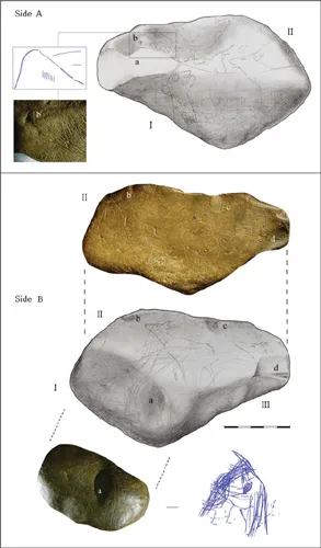
Perhaps it is no wonder, then, that some research suggests that children think in terms of mapping—using allocentric (from a third perspective) rather than egocentric (from the perspective of one’s self) representations of space from as young as three years old (Nardini et al. 2006). Humankind has used maps to represent and communicate information about space for at least as long as it has used formal written modes of communication. The oldest identified map may have been an engraved block cave in Spain showing landscape features and hunting sites. The map originates from about 14,000 years ago (Utrilla et al. 2009), 7,000 years before the first writing appeared in China, circa 7,000 BP (Figure 1.1).
FIGURE 1.1 A possible early map, from circa 13,660 BP (Utrilla et al. 2009, 101).
Determining what a map is, among pre-historical artifacts, is difficult because it first must be determined that (1) the author intended to represent spatial objects, (2) the objects represented are contemporaneous, and (3) the representations are cartographically appropriate (Smith 1987, 61). Take, for instance, a cave drawing of stick figure men and animals: is this an example of pre-historic art, or is there a spatial meaning inherent in the drawing that makes it a map, or at least map-like? Some of the artifacts that may be examples of pre-historical maps are rock paintings in Spain, drawings of humans in huts in Algeria, what may be Paleolithic engravings of riverside dwellings in Ukraine, as well as other re...
Table of contents
Cover
Half Title
Title Page
Copyright Page
Dedication
Table of Contents
List of figures
Acknowledgments
1 Introduction
2 Mapping concepts
3 The language of maps
4 Cartographic design
5 Coordinate systems and projections
6 Text and typography
7 Color in cartography
8 3D, animated, and web cartography
9 Scholarly research in cartography
10 Data in mapping
11 GIS and graphics software
12 Examples from the field
Appendix 1: Map gallery: “Maps from the wild”
Appendix 2: Sources of spatial data
Appendix 3: Eleven guidelines for constructing and critiquing maps
Appendix 4: Professional cartography societies
Glossary
Index
Frequently asked questions
Yes, you can cancel anytime from the Subscription tab in your account settings on the Perlego website. Your subscription will stay active until the end of your current billing period. Learn how to cancel your subscription
No, books cannot be downloaded as external files, such as PDFs, for use outside of Perlego. However, you can download books within the Perlego app for offline reading on mobile or tablet. Learn how to download books offline
Perlego offers two plans: Essential and Complete
Essential is ideal for learners and professionals who enjoy exploring a wide range of subjects. Access the Essential Library with 800,000+ trusted titles and best-sellers across business, personal growth, and the humanities. Includes unlimited reading time and Standard Read Aloud voice.
Complete: Perfect for advanced learners and researchers needing full, unrestricted access. Unlock 1.5M+ books across hundreds of subjects, including academic and specialized titles. The Complete Plan also includes advanced features like Premium Read Aloud and Research Assistant.
Both plans are available with monthly, semester, or annual billing cycles.
We are an online textbook subscription service, where you can get access to an entire online library for less than the price of a single book per month. With over 1.5 million books across 990+ topics, we’ve got you covered! Learn about our mission
Look out for the read-aloud symbol on your next book to see if you can listen to it. The read-aloud tool reads text aloud for you, highlighting the text as it is being read. You can pause it, speed it up and slow it down. Learn more about Read Aloud
Yes! You can use the Perlego app on both iOS and Android devices to read anytime, anywhere — even offline. Perfect for commutes or when you’re on the go. Please note we cannot support devices running on iOS 13 and Android 7 or earlier. Learn more about using the app
Yes, you can access How to Make Maps by Peter Anthamatten in PDF and/or ePUB format, as well as other popular books in Technology & Engineering & Typography. We have over 1.5 million books available in our catalogue for you to explore.