![]()
1
INTRODUCTION: CONCEPTS AND GEOMORPHOLOGY
Geomorphology is the science concerned with the forms and processes on the Earth’s land surface. Even with the fascinating challenges of explaining large-scale features such as the distribution of major mountain belts, spectacular landforms such as the Grand Canyon in the southwestern USA (Figure 1.1), or process events such as the Iceland volcanic eruption of Eyjafjallajökullin in 2010, geomorphology more generally has not captured the imagination of the general public as it could and should have done. There is today a need to advance geomorphic literacy in the way that climate literacy is being proposed (Climate Literacy, Global Change Program 2009),to some extent redressing a lack of student knowledge (Theissen, 2011). It is arguable that practitioners of geomorphology have not sufficiently emphasized the interesting and important underpinning concepts of the discipline as much as they might have. Nonetheless, recent heightened awareness of global environmental change, including the effects of both rapid climate change and increasing human impacts on the Earth’s surface, underlines the need to do so. A particular merit of geomorphology is that it has long recognized that our world is a changing one, and so the discipline has devised the means for interpreting sets of phenomena in terms of how they have developed in the past, and may develop in the future, beyond the timescales of individual human experience.
Geomorphology deals mostly with landforms on a human scale, although it may at the same time depend on comprehending physical, chemical and biological processes that range in their dimensions from the continental to the microscopic; forms range in size from minor slope features up to continent-scale landmasses. It also deals in timescales ranging from wind or water turbulence occurring in seconds to slow geological processes operating over millions of years: this poses rather obvious observational difficulties. There is a need to visualize happenings beyond everyday sensory appreciation, though no more so than for modern cosmologists studying the form and origins of the universe, or microbiologists deciphering the functioning of DNA. Landforms are also developed in complex spatial patterns that may be difficult to recognize at first sight. Over recent years many sciences have benefitted from the vastly greater availability of observational and analytical technologies. For geomorphology, this allows such things as the dating of Earth materials, the rapid assessment of sediment chemistry, the survey of river flows, computer modelling of emergent forms, and remote sensing of the Earth’s surface. Key ideas can now be rigorously subjected to what in the business world are called ‘proof of concept’ (POC) procedures, using prototype field studies, laboratory analysis, and physical or numerical modelling; much contemporary published research is of this kind. Necessarily highly technical, this may initially prove alarmingly incomprehensible for many readers. But underlying it all, whether in the minds of researchers to start with or developed as observations proceed, there are key ideas that have come to crystallize our present understanding of the world’s land surface.
The challenge for students of geomorphology, indeed of any discipline, is to find a comprehensible way into, and to become conversant with, modern research and its antecedents. With the advent of the internet and improved access to many sources, the research literature has burgeoned rapidly (with suggestions that the total amount of knowledge now doubles every 18 months), so it is easy to become overwhelmed with information and baffled by detail. In 2013 alone, the journal Geomorphology published 369 research papers, most of a highly technical nature. Consequently, many students have difficulty in distinguishing between basic underpinning concepts and useful but essentially research level technical material. This is not to belittle what are now indispensable techniques, or their on-going development that forms the focus for much dedicated present research. But for newcomers to the field without much technical knowledge, these can form an impenetrable initial barrier to understanding the things that the science is trying to do. One way of assisting such understanding is first to focus on concepts, which can be defined as those abstract ideas, general notions or units of knowledge that are vital to the development of a reliable science. There is a series of connections (Harvey, 1969: 19) between sense perceptions (percepts), mental constructs and images (concepts) to linguistic representations (terms). Although hitherto concepts have not featured prominently in any one geomorphology book it is important that we consider which concepts actually do underpin geomorphological thought (major concepts are shown in bold in subsequent chapters), and how such abstract or general ideas have been deduced or inferred from specific empirical data. Knowledge of these concepts, and their development, can provide the gateway to a more general understanding of what landform science is currently able to tell us.
Philosophy is the discipline concerned with an a priori analysis of concepts, as ideas are sought, possessed or understood, in coming to formulate beliefs (and ultimately knowledge) about the real world. Philosophers have given considerable attention to concepts, since Immanuel Kant (1724–1804) characterized those resulting from experience as a posteriori, and Arthur Schopenhauer (1788–1860) contended that concepts are ‘mere abstractions from what is known through intuitive perception’. Philosophers and others have recognized several types of concept although Machery (2009) argued that the dominant psychological theories of concepts have yet to be organized within a coherent framework. Laurence and Margolis (1999) suggested that there is still much controversy about what kinds of things concepts are, how they are structured and how they are acquired. For many, one of the traditional tasks of analytic philosophy is that of providing analyses of concepts which can be thought of as mental representations, as abilities peculiar to cognitive agents, or as abstract objects. Frames, which originated in logic-based artificial intelligence (AI), have been suggested as the basic format for concept formation in cognition because they are an excellent tool for the investigation of conceptual frameworks underlying scientific theories (hypotheses related by logical or mathematical arguments explaining a variety of connected phenomena) and their respective ontologies (the set of entities presupposed by theories) (Schurz and Votsis, 2007). A dynamic frames approach was developed by Lawrence Barsalou (1992) for the representation of concepts and the addressing of issues about conceptual change (see Andersen and Nersessian, 2000). Thus Key Concepts in Geography (Holloway et al., 2003) listed concepts including space, time, place, scale, physical systems, landscape and environment. Subsequently in a second edition Clifford et al. (2009) added nature, globalization, development, sustainability and physical geography, and risk. The breadth of things that could be regarded as underpinning concepts, explicit or implicit, is extremely wide.
For this book, we focus on concepts necessary for our current understanding of geomorphology as landform science. Those selected are less general than time and space, but also less specific than individual logical or mathematical theories linking entities (such as the relationship between river channel dimensions and discharge variables). Other expressions used for over-arching approaches are paradigms (Kuhn, 1962) and research programmes (Lakatos, 1970), but here we focus on concepts that relate specifically to geomorphology. In the remainder of this introduction we outline the development of geomorphology as a discipline, and its relationship to physical geography and to geology, ecology and environmental science (1.1). Subsequently we indicate the broad categories of techniques employed by geomorphologists (1.2), and then explain the chapter structure for the presentation of concepts in four major sections, indicating why the specified concepts have been selected (1.3).
1.1 Geomorphology as a discipline
In addition to four books in a series on the history of the study of landforms (Chorley et al., 1964; 1973; Beckinsale and Chorley, 1991; Burt et al., 2008) other works have traced the antecedents of the science of geomorphology in detail so that only a synopsis of the development of the science is provided here. The first use of the word geomorphology was in 1858 in the German literature (see Roglic, 1972; Tinkler, 1985). Table 1.1 suggests some of the founding assumptions prior to that date and indicates others that were subsequently influential. In geomorphology, as in any other discipline, the foundations of the discipline are significantly shaped by the contributions of single individuals, but similar ideas can emerge in more than one country. Whereas in the 19th and early 20th centuries ideas diffused relatively slowly, by the late 20th and early 21st centuries the speed of technical communication was so rapid that it is no longer easy to identify a single influence or the origin of ideas. Hence Table 1.1 is an approximation, compiled as a series of indicator milestones, to suggest the influences affecting the shaping of a discipline from the mid 19th century to the present day. Many ideas are cross disciplinary so that terms such as ‘evolution’, which would have been without great scientific meaning before about 1800, are now used (though with different technical definition and process underpinnings) from astrophysics to biology. In addition to individuals, there are wider influences: broader scientific ideas, researchers’ experience of particular regions, diverse publications and journals, the work of academic societies and technological developments, as well as the constraints set by financial limitations or the public policy demands of particular societies. The selection in Table 1.1 tells much about our perception but it can be supplemented by the reader. A different example reflecting writer perception is the cast of principal characters listed by Kennedy (2006) which omits some that we include but includes others that we do not.
In the light of developments summarized in Box 1.1 three particular motivational trends now recognized are: the need for more multidisciplinary research and investigations; the question about how far geomorphology can extend; and the potential to make further progress in relation to the management and design of environments (Gregory and Goudie, 2011b). However, a paradox now appears: despite the obvious importance of, and interest in, geomorphology as concerned with explaining the land surface of the Earth, the discipline itself ‘remains little known and little understood, certainly in relation to other academic disciplines, and especially outside university circles’ (Tooth, 2009). Appreciating the way that the science of landforms has grown as a discipline, and being mindful of the potential that it now has, mean that this is a particularly appropriate time to focus upon basic fundamental concepts. Table 1.1 provides the background for such concepts against the timeline of the development of geomorphology.
1.2 Techniques employed by geomorphologists
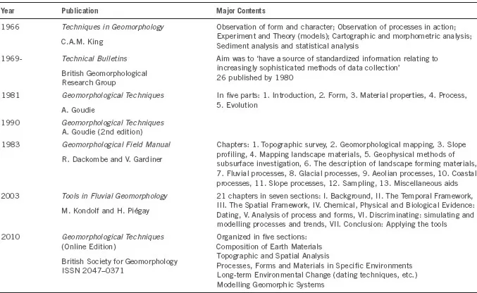
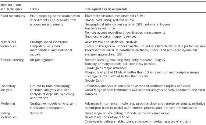
Technical advances are arguably enabling great progress to be made in the 21st century. In fact since 1960 changes in geomorphology are reminiscent of the way in which Chemistry and Physics were changed by the technological breakthroughs in the early 20th century. Thus Summerfield (2005b) described the subject as having ‘major research frontiers ranging in scale from the transport paths of individual particles over a river bed to the combined tectonic and surface processes responsible for the 100 million year history of sub-continental scale landscapes’. Before the 1960s geomorphology paid little explicit attention to techniques but used time-consuming methods of field surveying, field sketching, and mapping as appropriate. The way in which the scope of techniques available for the geomorphologist has changed is demonstrated by the content of books written to summarize those available (Table 1.2); to demonstrate the consequences of this explosion of techniques, Table 1.3 presents six categories, with an indication of those available fifty years ago, key developments since that time, and an outline of the contemporary range. Table 1.4 summarizes the range of dating techniques now available.
Many examples could be given of recent dramatic progress made possible, but DEMs of difference (DoDs), which quantify volumetric change between successive topographic surveys, and Structure for Motion (SfM) methods, which estimate three-dimensional structures from two-dimensional image sequences, illustrate the progress now possible. Overviews from space both allow geomorphologists not only to see and measure the characteristics of large landforms, but also to focus on metre scale forms in remote environments. Geomorphology is becoming far less concentrated on those landforms which are easily accessible in mid-latitude long-populated environments.
Table 1.2 Examples of publications reflecting the development of techniques in geomorphology
Table 1.3 A view of techniques for geomorphology
1.3 A structure for concepts
Many concepts in geomorphology have been generated following the empirical study of specific instances or occurrences of phenomena. These can be used to encapsulate the commonality between seemingly disparate localised phenomena, so that one would expect geomorphological texts to be concerned with linking concepts as basic to the d...