ArcGIS Pro 2.x Cookbook
eBook - ePub

ArcGIS Pro 2.x Cookbook

Tripp Corbin

Buch teilen
  1. English
  2. ePUB (handyfreundlich)
  3. Über iOS und Android verfügbar
eBook - ePub

ArcGIS Pro 2.x Cookbook

Tripp Corbin

Angaben zum Buch
Buchvorschau
Inhaltsverzeichnis
Quellenangaben

Über dieses Buch

Creating and Sharing Maps and Data using ArcGIS Pro

Key Features

  • Leverage the power of ArcGIS to build beautiful 2D and 3D maps.
  • Work with ArcGIS to analyze and process data.
  • Extend the power of ArcGIS to ArcGIS Online to create and edit content.

Book Description

ArcGIS is Esri's catalog of GIS applications with powerful tools for visualizing, maintaining, and analyzing data. ArcGIS makes use of the modern ribbon interface and 64-bit processing to increase the speed and efficiency of using GIS. It allows users to create amazing maps in both 2D and 3D quickly and easily.

If you want to gain a thorough understanding of the various data formats that can be used in ArcGIS Pro and shared via ArcGIS Online, then this book is for you.

Beginning with a refresher on ArcGIS Pro and how to work with projects, this book will quickly take you through recipes about using various data formats supported by the tool. You will learn the limits of each format, such as Shapefiles, Geodatabase, and CAD files, and learn how to link tables from outside sources to existing GIS data to expand the amount of data that can be used in ArcGIS. You'll learn methods for editing 2D and 3D data using ArcGIS Pro and how topology can be used to ensure data integrity. Lastly the book will show you how data and maps can be shared via ArcGIS Online and used with web and mobile applications.

What you will learn

  • Edit data using standard tools and topology
  • Convert and link data together using joins and relates
  • Create and share data using Projections and Coordinate Systems
  • Access and collect data in the field using ArcGIS Collector
  • Perform proximity analysis and map clusters with hotspot analysis
  • Use the 3D Analyst Extension and perform advanced 3D analysis
  • Share maps and data using ArcGIS Online via web and mobile apps

Who this book is for

GIS developers who are comfortable using ArcGIS, and are looking to increase their capabilities and skills, will find this book useful.

Häufig gestellte Fragen

Wie kann ich mein Abo kündigen?
Gehe einfach zum Kontobereich in den Einstellungen und klicke auf „Abo kündigen“ – ganz einfach. Nachdem du gekündigt hast, bleibt deine Mitgliedschaft für den verbleibenden Abozeitraum, den du bereits bezahlt hast, aktiv. Mehr Informationen hier.
(Wie) Kann ich Bücher herunterladen?
Derzeit stehen all unsere auf Mobilgeräte reagierenden ePub-Bücher zum Download über die App zur Verfügung. Die meisten unserer PDFs stehen ebenfalls zum Download bereit; wir arbeiten daran, auch die übrigen PDFs zum Download anzubieten, bei denen dies aktuell noch nicht möglich ist. Weitere Informationen hier.
Welcher Unterschied besteht bei den Preisen zwischen den Aboplänen?
Mit beiden Aboplänen erhältst du vollen Zugang zur Bibliothek und allen Funktionen von Perlego. Die einzigen Unterschiede bestehen im Preis und dem Abozeitraum: Mit dem Jahresabo sparst du auf 12 Monate gerechnet im Vergleich zum Monatsabo rund 30 %.
Was ist Perlego?
Wir sind ein Online-Abodienst für Lehrbücher, bei dem du für weniger als den Preis eines einzelnen Buches pro Monat Zugang zu einer ganzen Online-Bibliothek erhältst. Mit über 1 Million Büchern zu über 1.000 verschiedenen Themen haben wir bestimmt alles, was du brauchst! Weitere Informationen hier.
Unterstützt Perlego Text-zu-Sprache?
Achte auf das Symbol zum Vorlesen in deinem nächsten Buch, um zu sehen, ob du es dir auch anhören kannst. Bei diesem Tool wird dir Text laut vorgelesen, wobei der Text beim Vorlesen auch grafisch hervorgehoben wird. Du kannst das Vorlesen jederzeit anhalten, beschleunigen und verlangsamen. Weitere Informationen hier.
Ist ArcGIS Pro 2.x Cookbook als Online-PDF/ePub verfügbar?
Ja, du hast Zugang zu ArcGIS Pro 2.x Cookbook von Tripp Corbin im PDF- und/oder ePub-Format sowie zu anderen beliebten Büchern aus Computer Science & Cloud Computing. Aus unserem Katalog stehen dir über 1 Million Bücher zur Verfügung.

Information

Jahr
2018
ISBN
9781788295208

Editing Spatial and Tabular Data

In this chapter, we will cover the following recipes:
  • Configuring editing options
  • Reshaping an existing feature
  • Splitting a line feature
  • Merging features
  • Aligning features
  • Creating new point features
  • Creating new line features
  • Creating new polygon features
  • Creating a new polygon feature using autocomplete
  • Editing attributes using the Attribute Pane
  • Editing attributes in the table view

Introduction

We live in an ever-changing world. New infrastructure is added, old infrastructure is removed, regulations change, new needs are discovered, and so on. Our GIS must be able to keep up with these changes so that it accurately reflects the world we live in as closely as possible. This means we must be able to quickly and easily make changes to our GIS data, both spatial and tabular.
ArcGIS Pro provides a wealth of tools and methods you can use to make updates to your data. The tools available to you and the types of data you can edit or update will largely depend on the license level you have. For example, if you only have a Basic license, you are not able to edit data in an SDE geodatabase. However, you can edit a shapefile or feature classes in a file geodatabase. Here is a quick list of the data formats you can edit and at which license level:
Basic
Standard or Advanced
Personal Geodatabase
No
No
File Geodatabase
Yes, as long as not in Topology or Geometric Network
Yes
SDE/Enterprise Geodatabase
No (View Only with Basic)
Yes
Shapefile
Yes
Yes
DBF file
Yes
Yes
CAD Files (DWG, DXF, DGN)
No
No
Spreadsheets
No
No
ArcGIS Pro does not support the personal geodatabase at all and most likely never will. Esri has decided to replace the personal geodatabase with the file geodatabase because it provides much better performance. ArcGIS Pro Basic will allow you to edit data stored in a file geodatabase as long as it is not part of a topology or geometric network.
ArcGIS Pro cannot edit any data that is included in a Geometric Network. However, ArcGIS Pro 2.1 does support the newer Utility Network which was just released in its initial version in December 2017. The Utility Network provides similar functionality to the Geometric Network but is designed to be used in conjunction with the Utility Network Management extension for ArcGIS Enterprise. So it appears that the Utility Network will completely replace the older Geometric Network model. You can learn more about the Utility Network and the Management extension by going to https://www.esri.com/en-us/arcgis/products/arcgis-utility-network-management/overview.
An ArcGIS Pro Basic license will not allow you to edit data stored in an SDE Geodatabase either. SDE stands for Spatial Database Engine and provides multiple user capability for a Geodatabase. SDE Geodatabases require you to have ArcGIS Enterprise (formerly known as ArcGIS Server). With a Basic license, you can only view data in an SDE Geodatabase but not edit it. For more information about the different types of geodatabases, go to http://desktop.arcgis.com/en/arcmap/latest/manage-data/geodatabases/types-of-geodatabases.htm.
Shapefiles and DBF tables can be edited without any restrictions at all license levels. CAD files and spreadsheets can only be viewed in ArcGIS Pro and cannot be edited without converting them to a different format.
In this chapter, you will learn how to configure various editing options and use multiple tools. You will get to experience workflows for editing existing features as well as creating new features. Lastly, you will learn different methods for editing attributes and tables.

Configuring editing options

Before you start trying to edit data in ArcGIS Pro, there are several options you need to configure and verify. This will help ensure your edits are done smoothly and saved correctly. This will include setting your units, verifying tolerances, and more.
In this recipe, you will configure and verify several editing options, including how and when to save, setting your units of measure, making newly added layers editable by default, and configuring snapping.

Getting ready

For this recipe, you will need to ensure you have installed the book data and have ArcGIS Pro installed. The ArcGIS Pro Basic license level will be sufficient for this recipe.

How to do it...

  1. To get started, launch ArcGIS Pro.
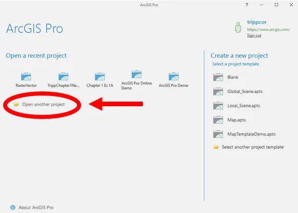
  2. In the ArcGIS Pro start window, click on Open another project.
  1. Select Computer from the Open window and then click Browse in the area on the right.
  2. Navigate to C:\Student\ArcGISProCookbook\Chapter4\Editing by clicking on C:\ in the area on the left of the Open Project window. Then double-click on Student, ArcGISProCookbook, Chapter4, and Editing folders.
  1. Select the Editing.aprx project file and click OK.
The project will open with a single map named City of Trippville. The map contains three layers, City Limits, Parcels, and Railroads plus the Topographic basemap. Now that you have a project open, you will begin setting various options that can impact how you edit data. You will start with the Application and Project options:
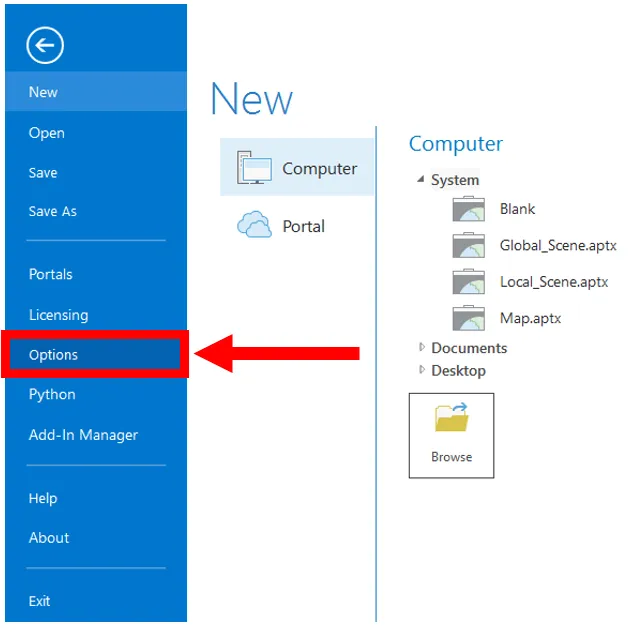
  1. Click on the Project tab in the ribbon
  2. Select Options from the panel on the left side of the Project pane, as shown:
  1. Select Units loc...

Inhaltsverzeichnis