
eBook - ePub
Cartographic Encounters
Indigenous Peoples and the Exploration of the New World
John Rennie Short
This is a test
Buch teilen
- English
- ePUB (handyfreundlich)
- Über iOS und Android verfügbar
eBook - ePub
Cartographic Encounters
Indigenous Peoples and the Exploration of the New World
John Rennie Short
Angaben zum Buch
Buchvorschau
Inhaltsverzeichnis
Quellenangaben
Über dieses Buch
There's no excuse for getting lost these days—satellite maps on our computers can chart our journey in detail and electronics on our car dashboards instruct us which way to turn. But there was a time when the varied landscape of North America was largely undocumented, and expeditions like that of Lewis and Clark set out to map its expanse. As John Rennie Short argues in Cartographic Encounters, that mapping of the New World was only possible due to a unique relationship between the indigenous inhabitants and the explorers.
In this vital reinterpretation of American history, Short describes how previous accounts of the mapping of the new world have largely ignored the fundamental role played by local, indigenous guides. The exchange of information that resulted from this "cartographic encounter" allowed the native Americans to draw upon their wide knowledge of the land in the hope of gaining a better position among the settlers.
This account offers a radical new understanding of Western expansion and the mapping of the land and will be essential to scholars in cartography and American history.
Häufig gestellte Fragen
Wie kann ich mein Abo kündigen?
Gehe einfach zum Kontobereich in den Einstellungen und klicke auf „Abo kündigen“ – ganz einfach. Nachdem du gekündigt hast, bleibt deine Mitgliedschaft für den verbleibenden Abozeitraum, den du bereits bezahlt hast, aktiv. Mehr Informationen hier.
(Wie) Kann ich Bücher herunterladen?
Derzeit stehen all unsere auf Mobilgeräte reagierenden ePub-Bücher zum Download über die App zur Verfügung. Die meisten unserer PDFs stehen ebenfalls zum Download bereit; wir arbeiten daran, auch die übrigen PDFs zum Download anzubieten, bei denen dies aktuell noch nicht möglich ist. Weitere Informationen hier.
Welcher Unterschied besteht bei den Preisen zwischen den Aboplänen?
Mit beiden Aboplänen erhältst du vollen Zugang zur Bibliothek und allen Funktionen von Perlego. Die einzigen Unterschiede bestehen im Preis und dem Abozeitraum: Mit dem Jahresabo sparst du auf 12 Monate gerechnet im Vergleich zum Monatsabo rund 30 %.
Was ist Perlego?
Wir sind ein Online-Abodienst für Lehrbücher, bei dem du für weniger als den Preis eines einzelnen Buches pro Monat Zugang zu einer ganzen Online-Bibliothek erhältst. Mit über 1 Million Büchern zu über 1.000 verschiedenen Themen haben wir bestimmt alles, was du brauchst! Weitere Informationen hier.
Unterstützt Perlego Text-zu-Sprache?
Achte auf das Symbol zum Vorlesen in deinem nächsten Buch, um zu sehen, ob du es dir auch anhören kannst. Bei diesem Tool wird dir Text laut vorgelesen, wobei der Text beim Vorlesen auch grafisch hervorgehoben wird. Du kannst das Vorlesen jederzeit anhalten, beschleunigen und verlangsamen. Weitere Informationen hier.
Ist Cartographic Encounters als Online-PDF/ePub verfügbar?
Ja, du hast Zugang zu Cartographic Encounters von John Rennie Short im PDF- und/oder ePub-Format sowie zu anderen beliebten Büchern aus Geschichte & Weltgeschichte. Aus unserem Katalog stehen dir über 1 Million Bücher zur Verfügung.
Information
Thema
GeschichteThema
WeltgeschichtePART I | introduction
Early America was a cloth woven from many threads,
but the Indian strands that ran through it have often been ignored,
forgotten, and allowed to fade from the nation’s history.
but the Indian strands that ran through it have often been ignored,
forgotten, and allowed to fade from the nation’s history.
Colin Calloway, 1997
1 Across the Continent: ‘Westward the Course of Empire Takes its Way’, an 1868 print by Frances Flora Bond Palmer published by Currier & Ives. | 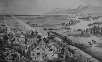 |
1 | Creation Myths and Cartographic Encounters
There is a timeline printed in the official Montreal Official Tourist Guide (2006–7); it begins with an entry beside the date 1535, ‘Jacques Cartier, who discovered Canada, returns upriver to the island that will later bear the name Montreal.’ It goes on, ‘Impressed with the mountain, he climbs it and calls it Mont Royal.’1
It is a story that explains and signifies a city’s birth in history. A similar tale is told for many cities and places around what they called the New World; heroic exploration by a founding father (or fathers) followed by an act of naming that marks a beginning in time and an origin in space. It is the dominant creation myth forged by Europeans for their New World.
In this book I want to look more closely at this and related myths. I will argue that their focus on discovery and exploration ignores the large, indispensable and vital roles played by the indigenous people. The tales should be less about discovery and more about collaboration. I want to replace these persistent myths with the notion of cartographic encounters. My basic argument is that the successful European and later American exploration of the New World resulted from the exchange of information between newcomers and indigenous people. This exchange can be read from contemporary accounts and is embodied in contemporary maps. I will deconstruct the texts and the maps to reveal that the European/American depiction of the land was very dependent on indigenous peoples.
Wider debates
Three wider debates situate the ideas in this book. The first is the changing account of indigenous people in the history of settler societies such as the United States. Initially the natives were noted, if at all, as background to the triumph of European exploration, colonization and settlement of the continent. They were portrayed as a barrier to European colonization, as part of the ‘natural’ landscape or simply passed over in silence. We have a visual representation of this approach in the 1868 painting and subsequent print by Frances Flora Bond Palmer entitled Across the Continent: ‘Westward the Course of Empire Takes its Way’. Reproduced many times, Palmer’s work was very popular and widely circulated in the United States. The title is taken from the sixth stanza of Anglican bishop and philosopher George Berkeley’s 1726 poem ‘On the Prospect of Planting Arts and Learning in America’, in which he presents the New World of North America as the ultimate site of civilization’s progress. Illus. 1 is the 1868 Currier & Ives lithograph based upon the painting. The image shows men clearing the forest around a small settlement and a rail line tracking across a flat plain, heading westward into the distance and the future. Across the Continent extols the idea and describes a practice of US progress. The church and school embody acts of civilization. If you look carefully you can see a couple of Native Americans on horseback, separate from the zone of civilization, partly hidden and probably choking on the smoke and steam from the train’s engine. Blocked and obscured, the original inhabitants of the continent are marginal to the optimistic forward push west towards the beckoning horizon, reduced to bit players, representatives of a dying past.
Countless western movies and novels, as well as serious academic studies, give Native Americans supporting roles, passive roles or no roles, passing them over in silent condescension. Things began to change in the second half of the twentieth century. As US progress began to seem at best a mixed blessing and for some a downright regression, Native Americans were recast in a rather romantic light, living in the pristine, pre-Fall Eden before the encroachment of urbanization, industrialization and commercialization. The career of the great director of the western John Ford (1894–1973) signals the shift. His earliest box-office success was The Iron Horse, which opened in 1924. It was a celebration of Manifest Destiny, the conquest of the West, the defeat of the Indians and the construction of the continental railway, the filmic equivalent of Palmer’s painting. Later, in Stagecoach (1939), he portrays the Apaches as savages who kill settlers and rape women. Their attack on the stagecoach of the movie title is almost successful but for the US cavalry who arrive in the nick of time to save the day. The Native Americans of the early Ford westerns are a threat and a nuisance, an irritant in the heroic making of the United States. In his later movies, especially Fort Apache (1948), She Wore a Yellow Ribbon (1949), Wagon Master (1950) and The Searchers (1956), Native Americans assume a more ambiguous role. Their defeat is still necessary for the making of the United States, but is now as much a source of regret as a cause for celebration. And in Cheyenne Autumn (1964) the camera turns a full 180 degrees to show the perspective of Native Americans displaced from their land. Ford remarked that he wanted to show the other point of view for a change. Cheyenne Autumn is a forerunner of later pro-Native American westerns such as Soldier Blue (1970) and Dances with Wolves (1990), in which the savages are the US cavalry.2
Francis Jennings provides an academic version of Cheyenne Autumn in his 1975 book The Invasion of America, in which the story of the European discovery, exploration and settlement of North America is represented as a story of genocide; it is history from the other side of the frontier, an account of loss and dispossession, of death and destruction. Jennings’s argument, often shorn of its subtlety, soon became a standard depiction in this more critical assessment of national history and national identity: it changed the Native Americans from shadows to victims, from savages to heroes. Richard White modified this stereotype somewhat in his 1991 book The Middle Ground, which showed the frontier not only as a place of defeat but also of negotiation. Contemporary western historical writing is now more aware of Native Americans as active agents as much as victims and of Europeans as constrained as well as triumphant. We now have a vigorous school of history that shows Native Americans as ‘friend and foe, trader and neighbor, fellow diplomat and fellow Christian’.3
However, I feel that perhaps we have moved too far in the direction of seeing this interaction as one of compromise and negotiation. White’s sensitive analysis, like Jennings’s before, has been reduced to a simplistic conclusion, the persistence of middle ground. But there was no lasting middle ground: one society became dominant at the expense of the other; one culture won, and one lost. I will use the term symbiotic destruction to refer to the European–Native American interaction, a relationship that involved choices and constraints, compromises and negotiations as well as conflicts and struggles, limitations on Europeans and exercises of Native American power, but set within the long-term story of eventual European victory and Native American defeat.
The second debate that helps to frame this book is the recent radical shift in the history of cartography. A story of mapmaking’s increasing scientific rationality has long dominated the narrative. Maps were milestones along this journey, laid out along an incline of an increasing knowledge of the world. This whole discourse was undermined by the postmodern turn, which emphasized maps as social constructions, stories marked by purposeful erasures and silences as well as inscriptions and disclosures. Influential scholars such as Brian Harley deconstructed maps for their ideology, their political undertones and their social contexts. Maps are now no longer seen as uncomplicated pictures of the geographic world: they are now understood to reflect power relations and embody the knowledge and ignorance, articulations and silences of the wider social world. Map accuracy and provenance are no longer the only considerations in this new history of cartography: it is now important to uncover maps’ narrative context, their truths as well as their lies, and to see the act of mapping as a political act as much as a scientific practice.4
There is a third debate nestled within this postmodern history of cartography. Malcolm Lewis writes of cartographic encounters between Europeans, European–Americans and Native Americans. He defines these encounters narrowly in terms of maps made by Native Americans in the course of their encounters with whites. I use an even wider definition of cartographic encounters, which recognizes that the maps made by white explorers drew heavily upon an indigenous cartographic contribution. Cartographic encounters result in maps made by the white Europeans in contact with the Native Americans as well as maps made by the indigenous people in contact with the white Europeans.5
A frontier is an important site for cartographic collaborations that embody a symbiotically destructive relationship. This was a relationship that allowed Native Americans to parlay their deeper and wider knowledge of the land into a strong bargaining position but, in this very exchange, where they had some leverage, lay the roots of their ultimate loss of land. They used the resources they had, such as geographical knowledge, to gain short-term advantages, such as trade goods and alliances with the powerful newcomers, but over the long term these cartographic encounters gave the newcomers enough knowledge and power to render superfluous the indigenous people. These encounters encapsulate the shared endeavour, the negotiated compromise that contains the seeds of defeat and victory.
Cartier and Columbus
Let us return to Jacques Cartier. The main facts of his explorations are the following: very little is known of his early life, but we do know that he undertook sea voyages to Brazil and Newfoundland before the Bishop of Saint-Malo proposed his name to the king of France as a likely leader of an expedition to the New World to find mineral wealth and a westward passage. The king accepted his nomination, and in April 1534 Cartier set off as leader of two ships and 61 men. He sailed to what is now Canada and entered the Gulf of St Lawrence, returning to France in September without any gold. He sailed again in 1534, this time with three ships, and sailed all the way up the St Lawrence River, landing at the site of Montreal, thus ensuring his later entry into the Tourist Guide. He spent two years in Canada before returning to France with news of a great river route, and returned to Canada for a third and final time in 1541. On his return to Saint-Malo he became a prosperous businessman and died on 1 September 1557. Cartier’s explorations were soon incorporated into other maps. Champlain’s explorations and maps of 1613 and 1632 are based on Cartier (illus. 2).
Cartier’s name lives on. In Montreal alone a bridge, a basin, a street, a place and a pier bear his name (see illus. 3). There are Jacques Cartier parks in Ottawa, Prince Edward Island and New York State. His name also lives on as the ‘explorer’ who ‘discovered’ the region. In the 1992 Atlas of North American Exploration, the introduction to a two-page spread on his voyages summarizes his contribution thus: ‘The Breton seafarer Jacques Cartier finds one of North America’s great rivers and travels a thousand miles into the interior of the continent.’6
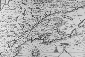 | 2 Samuel de Champlain’s 1613 map of New France, from Les Voyages du sieur de Champlain Xaintongeois (Paris, 1613). |
A record of Cartier’s journeys, purportedly in his own words, exists. And when we look at these words in some detail, a more complicated picture emerges than the simple story implied in the Atlas entry or the official city guide timeline.7 By mid June 1534 Cartier and his two ships entered the Gulf of St Lawrence. They sailed south along the western coastline of Newfoundland and across the gulf to what is now called the Gaspé Peninsula. On 24 July, ‘We had a cross made at thirty feet high, which was put together in the presence of a number of savages.’8 The ‘savages’ were Iroquoians from further south, on their annual summer fishing expedition. The leader of the tribe, Donnacona, his brother and three sons paddled up in canoes and disputed the implied claim. ‘And pointing to the cross he made us a long harangue . . . as if he wished to say that all this region belonged to him, and that we ought not to have set up this cross without his permission.’9
The French, by pretending they will trade an axe for the cloth the chief is wearing, lure the N...