![]()
Section II The Urban Design Process
The process this book introduces and discusses was developed to provide structure in education and practice for applied technical urban design. Loosely, the process follows a ‘stages of work’ pattern that those already operating in design disciplines will recognise: Analysis; Pre-Design; Design; Post-Design. The Urban Design Process as presented here is the culmination of a number of years’ work and development at the University of Manchester. As a design discipline we believe that urban design should be practised within a studio environment, where ideas can be shared and collaborations actively encouraged. In seeking ways to better engage MA Urban Design students in considering contextually responsive design solutions and interventions, we have developed a flexible process that can be followed to ensure more consistent and robust approaches to design. It is through these studio sessions, pedagogical evolution, and partnerships with major urban design practices in the North West of England, that we can be confident that this process works as a valuable tool for assisting in the development of contextually appropriate place(s).
While the process is presented in a linear fashion, from one stage to the next, it remains adaptable and flexible as the context of the site being developed is always unique. There are also a number of steps that require evaluation back through the process, ensuring a fluid approach rather than a check-box exercise. The process is intended to act as a guide, a road map for designers, it will inform and provide vital contextual information and clues to inform design, and also provide a robust framework for evaluating design decisions. It does not dilute the skill of the designer as a creative force, the process does not design, the designer does. The process better informs the designer and arms them with the necessary contextual detail to make more appropriate decisions and avoid generic or context-less results. The process also increases transparency in design development by providing a clear, flexible, and holistic approach where each stage informs the other – improving public trust and ensuring designers and key stakeholders are held accountable for their decision making.
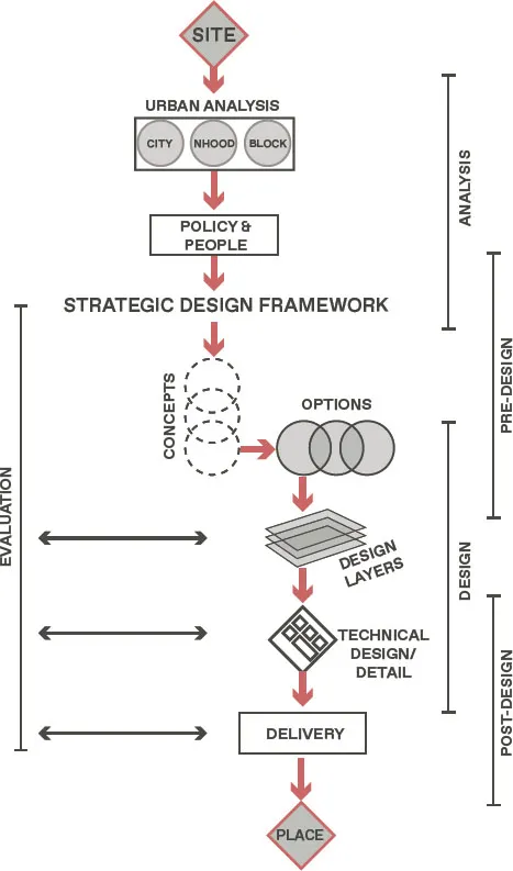
Figure 16
The Urban Design Process
The process, represented in Figure 16, works from initial site through to final place. What ties the analysis and the design development and detail together is the strategic design framework – this framework is developed through primary and secondary analysis (Urban Analysis and Policy and People). The framework then informs the development of the design through concepts and optioneering before acting as an evaluation matrix for the final design and the layers that make this work in practice. The delivery of the final design is a complex process, and this section concludes by considering the role of the other design disciplines, as well as the multiple realities that will impact on the process in the real world.
The site
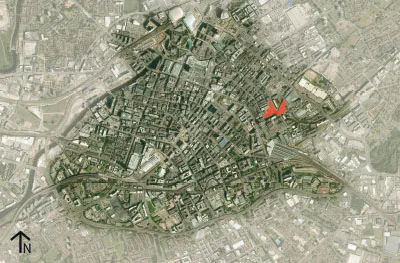
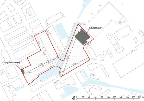
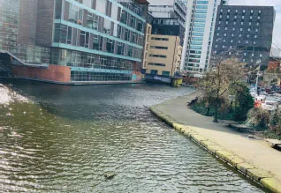
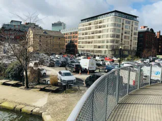
The process will be represented through a worked example on a site in Manchester, England (Fig.17). The site, approximately two hectares, is located close to the city centre on an area of vacant land known locally as ‘Piccadilly Basin’ due to the protected canal and lock that occupies the centre of the site (Fig.18). The site was selected as it sits on the boundary of the historic city centre and the industrial inner city and represents a prime brownfield location for future development (Fig.19 and Fig.20). It is also easily accessible to the authors allowing detailed analysis and regular site visits. To best showcase the process, we have taken this site through each stage to develop a final design solution.
Figure 17
Piccadilly Basin – city scale
Figure 18
Piccadilly Basin – site detail
Figures 19 & 20
Piccadilly Basin; current condition
Note from authors: The case study is intended to provide examples of each stage of the Urban Design Process (see Figure 16), to illustrate the relationships between them. It is not a complete project, nor should it be judged as such. Given the book format and the intention of including a case study, it was not possible to provide all analysis or detail. We have kept the examples as simple as possible to ensure readability and we also introduce internationally recognised case examples throughout to assist the reader in developing a clear understanding.
Urban analysis
Urban analysis is conducted across the three scales identified and described in the previous section – City, Neighbourhood, and Site. To conduct these forms of analysis the designer must employ both primary location-based analysis (visit the site and surroundings in person) and desk-based analysis (utilise the wealth of material available from digital and hard datasets and mapping to build an evidence base). To conduct the analysis, you should follow the simple guide of:
SCOPING
|
SENSING
|
SYNTHESISING
Urban analysis – three steps |
Scoping | Looking carefully at the variables identified at each scale, investigating these in depth on your particular site and its surrounding context. Involves visiting the site and surroundings on multiple occasions, at different times of day and night, in different weather conditions and during different activities (weekdays/weekend etc.). The scoping will provide the designer with a wealth of material, not all of which will prove relevant. |
Sensing | Identifying the key elements within these variables and those most pertinent to understanding the context of your site, both positive and negative. Involves making value judgements on your findings to discern the primary factors in relation to your site and surroundings. Sensing will result in the production of graphics representing these critical findings and enable the designer to build a clear picture of the site and context. |
Synthesising | To bring the separate key findings from each of these variables together to form a single piece of analysis. Involves the production of multi-variable graphics that provide clear conclusions on the scoping and sensing. Synthesising will result in three principal graphics across the three scales – a Strategic Location Map (City); a Contextual Appraisal (Neighbourhood); and an Opportunities and Constraints Plan (Site). Later, in conjunction with policy and secondary analysis, these will inform the development of the strategic design framework. |
The city
The location of your site within its city or regional context can be of extreme importance in developing design solutions or interventions. The Strategic Location Map for Piccadilly Basin (Fig.21) illustrates the potential inherent in the site’s geography and the access to wider networks beyond the immediate surroundings. The close proximity to Piccadilly Station (within a 500m radius), for example, provides the site with nationwide accessibility and direct links to London and other major cities in the UK. The site is also near to major transport routes to the city of Leeds and the ring road around Greater Manchester. The ability to quickly access key routes to the International Airport, the Ox...