![]()
JEFFERSON’S EPIC REAL ESTATE DEAL OF THE 19TH CENTURY
The first major installment of westward expansion occurred in 1803, when President Thomas Jefferson acquired from France some 828,000 square miles of land, stretching from the Mississippi River to the Rocky Mountains. The price was $15 million or around 3 to 4 cents per acre—not too bad! But little was known about this unexplored frontier inhabited almost entirely by Native Americans. Obviously, an expedition should be mounted to check it out. Meriwether Lewis and William Clark were tapped to lead the Corps of Discovery on its epic journey up the Missouri River and ultimately to the Pacific Ocean.
![]()
THE LEWIS & CLARK TRAIL
“The object of your mission is to explore the Missouri River & such principal streams of it, as, by its course and communication with the waters of the Pacific Ocean, whether the Columbia, Oregon, Colorado or any other river, may offer the most direct and practicable water communication across this continent for the purpose of commerce.” —Thomas Jefferson, President, Washington, D.C., June 20, 1803
ILLINOIS AND MISSOURI: OUR JOURNEY BEGINS
Kayla Cavaliere, my 19-year-old granddaughter, and I are racing through Dulles Airport to catch an early morning flight to St. Louis. We meet up with Jeff Arpin, the third member of our expedition, behind a rapidly forming line of frenzied passengers heading into security. Slipping into my seat and buckling up for takeoff, I recall that Meriwether Lewis left Washington, D.C., on July 5, 1803, to begin preparations for his voyage up the Missouri River. During his trip to the fur-trading outpost in St. Louis, Lewis acquired boats, men, provisions, and his co-captain, William Clark. The idea for the excursion was spawned by Thomas Jefferson’s Louisiana Purchase from France for the bargain price of $15 million.
After arriving on the banks of the Mississippi River near St. Louis, winter quarters were constructed. The Corps of Discovery’s expedition would begin some 11 months after Lewis departed Washington. In contrast, our 21st century flying machine will have us in St. Louis within a few hours, and then we’ll begin our own journey along the Lewis & Clark Trail tomorrow.
ST. LOUIS
“I Set out at 4 oClock P. M. in the presence of many of the Neighbouring inhabitents, and proceeded on under a jentle brease up the Missourie …” —William Clark, May 14, 1804
Our modern-day adventure begins in Illinois on the east bank of the Mississippi River at approximately the same location where the Corps of Discovery set out in 1804. We ascend the Lewis & Clark Confluence Tower in an elevator, which slows to a stop at the 150-foot high observation deck. We are greeted by a bird’s-eye view of the confluence of the Mississippi and Missouri Rivers. The 2,341-mile “Mighty Mo” collects the drainage from more than a half million square miles of topography in parts of 10 states and two Canadian provinces.
Just down the road from the tower, we find the Lewis & Clark State Historic Site’s Visitor Center. Touring the exhibits, we’re fascinated by a full-scale replica of the type of keelboat used by the explorers. A cutaway section illustrates how every available space was packed full of provisions for the long trip.
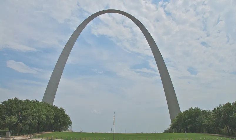
We’re tingling with excitement as we start our 21st century expedition along the Lewis & Clark Trail. Crossing west over the Mississippi on the McKinley Bridge, the iconic Gateway Arch dominates the St. Louis skyline. A few minutes later, we’re parked and looking up in awe at this massive man-made structure.
We scan the grounds for the Visitor Center and Museum of Westward Expansion, but no such building is in plain sight. People walk along sidewalks, but then they disappear from view. The mystery is soon solved, however, as we too descend a ramp into the cavernous underground visitor center and museum. It’s chock-full of 19th century artifacts and provides a cool respite from the triple-digit temperatures and oppressive humidity above ground.
Our last stop of the day is at William Clark’s gravesite in Bellefontaine Cemetery. I know from previous research that the gravesite is marked by a large obelisk and naively believe that finding it will be simple. Entering the cemetery’s labyrinth of roads, we’re confronted with literally hundreds of obelisks. But a courteous landscaper leads us to Clark’s. Under his bust, the inscription reads: “SOLDIER, EXPLORER, STATESMAN AND PATRIOT. HIS LIFE IS WRITTEN IN THE HISTORY OF HIS COUNTRY.”
Just as Lewis and Clark kept journals of their travels, Jeff and I will do the same.
“… adventures like the one we are undertaking are all about learning and laughing, about having experiences large and small, serious and humorous, that we will have for a lifetime. Tomorrow we head west. I can’t wait.”
—Captain Jeff
MISSOURI RHINELAND
“Set out from St. Charles at three oClock after getting every matter arranged, proceeded on under a jentle Breese ...”
—William Clark, May 21, 1804
Our first stop is in historic St. Charles, MO, which is perched on the banks of the Missouri River about 25 miles from its mouth. St. Charles is where Lewis and Clark made final preparations for the expedition. Bumping along generously shaded, brick-paved streets, we see many historic buildings in this charming village, which is one of the oldest in the state.
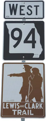
By mid-morning, we’re zooming west on SR 94. Signage confirms that we are indeed following the Lewis & Clark Trail. Although the river is mostly obscured from sight, my GPS shows that it’s close by. We stop at Klondike Park and climb to the top of a bluff. Far below, the river extends to the horizon in both directions. Back on the road, we snake our way via a tightly wound path across the Missouri Rhineland’s undulating landscape.
At the end of this long, hot day, one member of our group is noticeably upbeat. Kayla has spent hours surfing the web with her smartphone for reviews of tonight’s lodging. I surmise that she has a mortal fear that 21st century captains Jim and Jeff will book her into some seedy motel. Well, not to worry, because she will have exquisite accommodations in Boonville’s historic, circa-1905 Hotel Frederick.
WONDER DOG AND A SUPER RACE
“… a high commanding position, more than 70 feet above high-water mark, and overlooking the river, which is here but of little depth.”
—William Clark, June 23, 1804
Another scorcher of a day finds us navigating through expansive farmlands of mostly dead cornstalks that have been burned to a crisp by drought and record heat. Arriving in Marshall, MO, I catch a glimpse of signage announcing “Jim the Wonder Dog Memorial Garden.” Uh-oh, I’m hoping that Jeff is looking the other way and doesn’t see it, because otherwise I’m going to suffer through unrelenting ribbing about my namesake dog. Well, he does see it, and as soon as we park the harangue begins.
During our inevitable stroll through canine Jim’s memorial garden, we learn that he was reputed to have possessed amazing powers. Reportedly, Jim could correctly predict the outcome of future events, like the winner of seven Kentucky Derbies, a baseball World Series, and the sex of countless unborn babies. Legend has it that this Llewellin Setter could understand and act on commands given to him in any foreign language, as well as Morse code and shorthand. What a pooch!
Motoring across a progressively flatter Missouri landscape, we stop for a tour of reconstructed Fort Osage. During their trek up the Missouri River, Lewis and Clark noted that this particular high bluff would make an excellent location for a future fort. Clark returned to the area in 1808 to oversee construction of one of the first military outposts and trade houses in the Louisiana Purchase.
The fort was named after the indigenous Osage Indians who frequently traded here. We’re told that the physically robust males were often seven feet or taller and that many women were six feet or more. It’s believed that, over the centuries, the tribe’s selective breeding facilitated superior size and athletic ability. Too bad there wasn’t an NBA back then because they clearly would have been the team to beat.
Our destination for the night, downtown Kansas City, sits atop a hill near the confluence of the Missouri and Kansas Rivers. Stepping onto the sidewalk, we are refreshed by a cool, dry breeze sweeping in from the west. Feeling further revived after a long shower, we’re soon headed to the festive Power & Light District for fun and food.
“Missouri is a place of many unusual sights. It is home to the world’s largest eight-ball, largest fork, largest Solo cup, largest shuttlecock, largest banjo, largest pencil, largest rocking chair, and largest underpants. We did not see any of these and must consider this one of our great disappointments so far. Tomorrow we start our long journey north, continuing along the Missouri River.” —Captain Jeff
TURNING NORTH
“Set out from the Kansas river ½ past 4 oClock ...” —William Clark, June 29, 1804
The Missouri’s course has us heading north. We arrive in historic St. Joseph and spend several hours touring the notable Patee House Museum, learning much about the area’s history. One of the most iconic exhibits is Jesse James’ former residence, which was relocated here. There’s a noticeable hole in the wall that reportedly was made by the bullet that took Jesse’s life; something dark to ponder as we leave.
“It’s July 4, 1804, and the Corps of Discovery is celebrating Independence Day on the Missouri River near present-day Atchison, KS. Before they can build their winter quarters in modern-day North Dakota, the expedition still has more than a thousand miles of Missouri River to navigate. We should be there in a week.” —Captain Jim
INTO THE GLACIAL PRAIRIE
It’s mid-afternoon as Jeff, Kayla, and I motor across the bridge into Kansas. There we pick up the Glacial Hills Scenic Byway and continue our journey. Graceful sweeping curves follow the meandering course of the Missouri. The geological handiwork of receding glaciers is clearly evident in the gently rolling terrain. About 50 years after Lewis and Clark came through here, the Kansas-Nebraska Act opened up the Kansas Territory for settlement. The land’s rich soil virtually begged for cultivation.
The byway connects many of the state’s oldest towns. The high bluff (and future site of White Cloud, KS) is believed to have been a vantage point and resting place for Lewis and Clark. White Cloud, once a grand riverboat town of some 2,000 people, is now a virtual ghost town. Vacant buildings are slowly disintegrating into dust to be blown away by the relentless prairie w...