Geography
Concentric Zone Model
The Concentric Zone Model is a theory in urban geography developed by sociologist Ernest Burgess in 1925. It describes the spatial arrangement of cities into a series of concentric rings, with the central business district at the core and residential areas expanding outward. The model suggests that urban land use and social structures are influenced by this spatial organization.
Written by Perlego with AI-assistance
Related key terms
1 of 5
10 Key excerpts on "Concentric Zone Model"
 eBook - PDF
Visualizing Human Geography
At Home in a Diverse World
- Alyson L. Greiner(Author)
- 2017(Publication Date)
- Wiley(Publisher)
This model was based largely on his observations of San Francisco, where the suburbs had become self-sufficient centers. Each suburb was a new urban realm—an independent entity with its own down- town or commercial center. Vance’s model recognizes the In 1939, the economist Homer Hoyt proposed the sector model to describe the land-use patterns and spatial structure of cities. This model places greater em- phasis on the role of transportation and incorporates Hoyt’s observation that the location of high-income groups influences the direction of a city’s growth. New high-class neighborhoods tend to be built along the outer edges of cities. This sets in motion a process of succession called filtering. As Kenneth Jackson, an expert in urban history, concisely explains, filtering is “the se- quential reuse of housing by progressively lower income households” (1985, p. 285). Figure 8.11 compares and contrasts the sector and Concentric Zone Models. Multiple nuclei and urban realms models In 1945, two geographers, Chauncy Harris and Edward Ullman, proposed the multiple nuclei model as an alternative way of understanding the urban spatial structure of North American cities. Harris and Ullman observed that cities Early models of North American cities • Figure 8.11 Early studies of U.S. cities gave rise to these two, now classic, models of urban structure. ▲ a. Burgess’s Concentric Zone Model Similar patterns of land use develop around the CBD in rings, or in the case of Chicago, concentric arcs because of the city’s lakefront location. Nonresidential land use occurs primarily in the Loop, the local name for the CBD, and spreads into the zone in transition, which is also the destination of newly arrived immigrants. eBook - ePub
- 'Bola Ayeni(Author)
- 2017(Publication Date)
- Routledge(Publisher)
The third major approach to understand urban spatial structure is based on micro-economic considerations of household behaviour. In this regard, it has been argued that the urban land-use pattern is determined by the urban land-rent mechanism, which provides the theoretically perfect site in terms of the trade-off between site rentals and the cost of overcoming the friction of distance. Micro-economic theory of urban spatial structure pioneered by Wingo (1961) and Alonso (1964) has been very valuable in terms of researches generated both on theoretical and empirical fronts as well as in the general orientation of urban research. None the less, it is generally recognised that while these models and theories are laudible, they have not succeeded in totally explaining urban spatial form.In this chapter, therefore, we shall provide a synthesis of the major tenets of these traditional approaches and in particular attempt a critical evaluation of the assumptions and hypotheses that underlie their formulation. We believe this is the only way to examine the applicability of these ‘North American’ models to cities in other parts of the world, where there may be cross-cultural differences as well as differences in societal value systems. Furthermore, it is expected that our synthesis will generate a suitable conceptual framework for much of the development of methods and techniques in the rest of the book.2. Classical Models of Urban Spatial Structure
(i) The Concentric Zone Model
The Concentric Zone Model, developed by Burgess (Park et al., 1925), is really the first set of ideas towards the theoretical understanding of the city. It postulates that urban land use is arranged around a single centre, the central business district (CBD), in concentric zones made up of the zone in transition, the zone of the independent working men’s homes, the zone of better residences and the commuters’ zone (see Figure 1.2.1 ). The central business district is the hub of all urban activities, including financial, economic, social and recreational functions. In may also have some light manufacturing activities towards its outer fringes. The second zone comprises areas of residential deterioration as a result of the encroachment of business and industrial activities from the first zone and it is usually occupied by first-stage migrants. The third zone, the zone of independent working men’s homes, comprises largely the residences of second-generation migrants into the city, while the fourth zone contains the residences of the middle class and is occupied by managers, clerks, salesmen and professional people. The last zone, the commuter’s zone, is a ring of encircling small cities, towns and hamlets which serve as dormitory suburbs for the wealthier city-dwellers (see Figure 1.2.1 eBook - PDF
- Paul N. Balchin, David Isaac, Jean Chen(Authors)
- 2019(Publication Date)
- Red Globe Press(Publisher)
Ecological Theories of Urban Development Influenced by ecology, which studies the relationship between living organ-isms and their physical environment, Park and Burgess (1925) suggested that human beings compete for scarce resources such as land and raw mate-rials with the aim of establishing spatially-disparate urban environments to satisfy their different economic and social needs. As in ecology, the bound-aries between such environments are continually changing – largely as an outcome of demographic and economic centripetal forces of attraction, centrifugal forces of dispersal and the forces of spatial differention; and by means of the economically and politically-strong acquiring land at the expense of the weak. From this basic premise, a number of ecological the-ories of urban land use emerged throughout the twentieth century – most notably the concentric zone, sector and multiple nuclei theories of respec-tively Burgess, Hoyt, and Harris and Ullman. Concentric zone theory This emerged from a study of Chicago by Burgess (1906) and was essen-tially an application to urban land use of von Thünen’s earlier theory relat-ing to rural land around a city (see page 83). It was suggested that any city extends radially from its centre to form concentric zones and that as dis-tance from the centre increased there would be a reduction in accessibility, rents and densities. Land use would assume the following forms from the centre outwards: the central business district, a zone of transition, an area of factories and low-income housing, an area of higher-income housing and a commuter zone (figure 3.2). There would also be declining proportions of recent immigrants, delinquency rates, poverty and disease as distance increased from the centre. The concentric zone theory allows for underlying conditions to change continually. Natural population increase, in-migration, economic growth The Spatial Structure of Urban Areas 87 eBook - ePub
- Alfonso Valenzuela Aguilera(Author)
- 2022(Publication Date)
- Routledge(Publisher)
Burgess, 1925 , p. 56). The model advanced a concentric configuration of land use that started with the central business district, with locations appraised according to their accessibility to the center.Based on the foregoing analysis, a rental supply curve can be generated (Fig. 1.3 ), in which consumers compete to acquire or rent properties closer to the center, thus creating concentric rings of land use. Location patterns were detected based on the expansion and transformation mechanisms observed in the city, wherein the center responds to different uses. Starting from this point, Burgess located the first ring of slums where the immigrant ghettos were to be found:clinging close to the skirts of the retail district lies the wholesale and light manufacturing zone. Scattered through this zone and surrounding it, old dilapidated buildings form the homes of the lower working classes, hoboes, and disreputable characters. Here the slums are harbored. Cheap second-hand stores are numerous, and low priced men only moving picture and burlesque shows flourish.(Burgess, 1925 )Fig. 1.3 Concentric ring model according to land value.Source: Burgess, 1925 .Considered a working-class transition zone, the second concentric ring of the city housed a manufacturing sector comprising recent migrants, indigents, and criminals, while theories of social disorganization characterized these areas as generators of crime and moral decay. Burgess adds that his research found the greatest concentration of social and environmental deprivation in these areas of physical decay and social disorganization, also stressing, however, the possibility for inhabitants of said areas to transcend these conditions and move out (Burgess, 1925 eBook - PDF
Urban Geography
An Introductory Analysis
- James H. Johnson, W. B. Fisher(Authors)
- 2013(Publication Date)
- Pergamon(Publisher)
Burgess also expected that there would be considerable variation within his various zones: local natural areas, distinguished by the social, economic and demographic traits of their inhabitants, were to be expected within the broader zonal framework. In practice, too, many cities show a star-shaped rather than a con-centric form, with urban development pushing along the highways which radiate from their centres and with contrasting types or urban land use being found in the interstices between the main roads. Apolo-gists for the Burgess theory have suggested that if such a city were re-mapped in terms of the time and cost of travelling to the centre, rather than of the linear distance involved, a concentric arrangement would be produced. If this view is correct, similar types of land use are likely to be found at the same journey time from the centre. The theory has also been modified by the suggestion that identical urban regions are not to be expected in concentric zones, but merely that particular types of land use tend to occur at the same distance from the centre, often in patches rather than forming a continuous ring. This approach has developed into the statistical study of traverses from the city centre to the suburbs; but in studies of this kind the emphasis has been on economic rather than on sociological analysis and must be discussed later. The Sector Theory Even after suitable allowance has been made for its general character, there remain certain discrepancies between the concentric theory and reality, encouraging the postulation of other theories of urban structure. One of the most important of these is the Sector Theory, which was first Theories of Urban Structure 173 MULTIPLE NUCLEI THEORY after Harris and Ullman Central Business District 1 Wholesale Light Manufacturing 2 Low-class Residential 3 Medium-class Residential 4 High-class Residential 5 Heavy Manufacturing 6 Outlying Business District 7 Residential Suburb 8 Industrial Suburb 9 FIG. eBook - ePub
Living With Energy Shortfall
A Future For American Towns And Cities
- Jon Van Til(Author)
- 2019(Publication Date)
- Routledge(Publisher)
This chapter begins with the contemporary landscape of the United States and the ways people have built upon it. Looking at the form and shape of a city, town, or suburb, the viewer quickly becomes aware that these settlements spread across the continent possess distinctive shapes of their own. These varying shapes are apparent to residents and urbanists alike. Kevin Lynch has shown in his studies of how people perceive cities that key elements of their form, such as central landmarks and boundaries between neighborhoods, are stored in the mental maps that most residents carry with them of the places in which they live. Urban sociologists and geographers, initially convinced that a single pattern of urban form could be determined, have more recently come to conclude that metropolitan forms are multiple and vary with local forces and choices in the city's development process.The classic work on the form of U.S. cities and suburbs was done by sociologist Ernest Burgess, who described in a chapter in the influential text, The City, a circular zone theory of urban spatial form.The typical processes of the expansion of the city can best be illustrated, perhaps by a series of concentric circles, which may be numbered to designate both the successive zones of urban extension and the types of areas differentiated in the process of expansion.This chart represents an ideal construction of the tendencies of any town or city to expand radially from its central business district-on the map "The Loop" (I). Encircling the downtown area there is normally an area of transition, which is being invaded by business and light manufacture (II). A third area (III) is inhabited by the workers in industries who have escaped from the area of deterioration (II) but who desire to live within easy access of their work. Beyond this zone is the "residential area" (IV) of high-class apartment buildings or of exclusive "restricted" districts of single family dwellings. Still farther, out beyond the city limits, is the commuters' zone-suburban areas, or satellite cities-within a thirty- to sixty-minute ride of the central business district.When other urbanists sought to apply the Burgess zonal model to their own cities, different patterns of urban form sometimes provided a closer fit. Maurice Davie found, for instance, that New Haven was more accurately understood by using a radial model, or what Homer Hoyt would later call a "sector" model. In this image of urban form, major land uses clung to arteries of transportation as they led to and from the city's core, forming a wedgelike pattern of land use. Support also emerged for what Harris and Ullman called the multiple nucleus theory, in which major functions of land use were seen to develop throughout the metropolis. eBook - ePub
Residential Change and Demographic Challenge
The Inner City of East Central Europe in the 21st Century
- Annett Steinführer, Sigrun Kabisch, Katrin Grossmann, Annegret Haase(Authors)
- 2016(Publication Date)
- Routledge(Publisher)
To explain the socio-spatial structures of a particular inner city, the historical perspective is indispensable. One of the first scientific approaches to the inner city was developed by the Chicago School in the early part of the 20th century. Although the models and theories were developed almost a century ago, and referred to industrialized and growing American cities, they provide a sufficiently broad scope of interpretation and generalization which is still relevant to contemporary urban issues. In the concentric zonal model of a city, developed by Burgess (1927), the notion of inner city is used and defined in a precise way. It refers to two out of five identified zones. A ‘zone in transition’ surrounding the central business district (CBD) contains old factory complexes, interspersed with areas of deteriorating tenement neighbourhoods. This zone is the main area of the city which absorbs those new migrants to the city who are not able to compete economically for the better residential locations. It is an area with a permanently high degree of mobility and change. In this zone, ethnic minorities are often housed in poor conditions. As a result, the zone in transition can become an area of high crime rates and social disorganization. Beyond the ‘zone in transition’ lies a belt of more settled working-class housing which was also identified as part of the inner-city area.The concept of invasion-succession theorized the process of inner-city changes. As new commercial enterprises are established and new immigrants arrive to residential areas around the CBD, the ‘zones in transition’ expand into the zone of workers’ homes and impel longer established groups to migrate outwards towards the suburbs. As the immigrants move up in socio-economic status, they in turn move outwards and are replaced by newer immigrants. Thus, a non-random spatial pattern emerges, with lower socio-economic status groups located centrally. The Chicago School’s perspective highlights the continuing state of change and transition characterizing the inner city. Selecting the inner city as a focus of residential change and demographic challenge of contemporary East Central European cities firmly locates this study in more general traditions of urban research.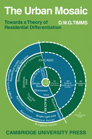 eBook - PDF
The Urban Mosaic
Towards a Theory of Residential Differentiation
- Duncan Timms(Author)
- 1975(Publication Date)
- Cambridge University Press(Publisher)
The return of certain high status populations to the inner city, as the problems of transportation take on a more costly appearance may yet herald a return to the traditional pattern - albeit at a vastly increased scale. The position with regard to the distribution of other population character- istics remains obscure. In general, what little cross-cultural evidence there is argues in favour of the Burgess zonation as a framework for the distribution of different family types wherever these emerge as a separate dimension of social differentiation. Thus in Calcutta, Berry and Rees find 'a clear and strong land- use and familism gradient . . . from commercial core 10 residential peri- phery'. 2 As yet, however, the evidence is too scant to warrant generalization. A final verdict on the utility of the Burgess model as an empirical instru- ment must await the provision of further cross-cultural material. The data to hand only allow the conclusion that it is by no means a universal frame- work for the distribution of socio-economic status groups. This by no means rules out its potential value as an analytical framework for the description of other forms of social differentiation, such as that composed by the familism dimension. In Quinn's words: If... a zonal system is to be accepted it must be conceived as a device of limited value in the interpretation of the city. It will not be a composite, universal frame of reference for the interpretation of all urban phenomena but will be limited to such single factors or combinations of them as correspond in distribution to the zonal pattern. 3 THE SECTOR MODEL OF URBAN GROWTH AND STRUCTURE The Burgess model of urban growth and structure was evolved in connexion with the wide-ranging interests of the Chicago ecologists. Despite its empha- sis on family status and style of life considerations, it was put forward as a 1 Caplow, 'Social ecology of Guatemala City' in Theodorson, Studies in Human Ecology, p. eBook - ePub
- Dennis Mills, Dennis R. Mills(Authors)
- 2016(Publication Date)
- Routledge(Publisher)
10 Socio-Spatial Segregation and the Roles of Urban Landowners DOI: 10.4324/9781315622095-11‘Even when the houses were brand new, they were suitable only for people who lived very similar lives, and whose conduct varied very little from a fairly restrictive norm.’ K. Coates and R. Silburn, Poverty: The Forgotten Englishman (Penguin, Harmondsworth, 1970), p. 80, describing the working-class district of St Ann’s, Nottingham, built in the mid-Victorian period and rebuilt in the 1970s.Segregation
Despite the fact that no really effective methods of measuring its increase have been devised, it is generally agreed that the growth of large cities has been accompanied by an intensification of socio-spatial segregation. In towns large enough to have developed distinctive residential zoning before industrialisation the effect was to invert the earlier pattern of high status residences in the principal streets with low status suburbs, because high income groups moved out and left the central areas to industry and commerce.1It is also generally agreed that segregation, has become much more complex, with the growth of urban populations and an increase in the range of urban functions. For the pre-industrial period, opinion wavers between a two-zone and a three-zone model. The two zones common to both models are (1) the central areas occupied by the merchants and master craftsmen and (2) the peripheral areas occupied by the labouring poor. In some towns, however, there may have been sufficient gentry to inhabit a distinctive high status, non-commercial district, possibly in association with a cathedral close.2In the nineteenth-century town there developed specialist retail, wholesale, financial, administrative, transportation and industrial areas, most of them near the centre of the urban mass. Around this central business district, there developed concentric rings of housing, progressing up the social scale with distance from the centre (the Burgess model). These rings were frequently interrupted not only by natural features (e.g. river valleys carrying canal and railway routes, which attracted industry), but also by higher class sectors or wedges (the Hoyt model) and by the prior existence of older settlement nuclei (the Harris and Ullman model).3 eBook - PDF
Urban Economics and Real Estate
Theory and Policy
- John F. McDonald, Daniel P. McMillen(Authors)
- 2015(Publication Date)
- Wiley(Publisher)
Residential households near the in- dustrial area are compensated for their exposure to pollution by getting low land rents and house prices. The allocation of land uses is stable—there is no tendency toward change—because the industrial sector expands up to the distance where land rents are just the same in industrial use as they are in residential use. Zoning uses the power of the state to create boundaries between land uses. The boundaries in- crease land rents for the restricted sector and lower rents for the sector that is left with more land than before. Zoning creates a discontinuity between land rents at district boundaries. A large difference in land rents creates an incentive to change the zoning policy. Landowners will attempt to get their parcels added to the district if restrictive zoning raised land rents. In the long run, zoning officials may well have an incentive to follow the market as landowners lobby to have their parcels zoned for the use that produces the highest land rents. I E. CONCLUSION This chapter has shown how the monocentric city model can be used to predict how changes in key variables affect the spatial arrangement of eco- nomic activity in an urban area. A decline in com- muting costs leads to a more decentralized city with higher housing prices and land rents in more distant locations and lower housing prices and rents near the city center. Population densities, capital/land ratios, and building heights also increase at distant locations while falling near the city center. In con- trast, a population increase or an increase in agri- cultural land rents simply leads to a more densely populated urban area, with higher housing prices, land rents, population densities, capital/land ratios, and building heights at all locations. The effect of income changes on the spatial layout of the monocentric city is more complex.
Index pages curate the most relevant extracts from our library of academic textbooks. They’ve been created using an in-house natural language model (NLM), each adding context and meaning to key research topics.