Geography
Western Desert
The Western Desert refers to a vast arid region located in the western part of Australia. It is characterized by its harsh and unforgiving landscape, with sparse vegetation and extreme temperatures. The area is home to several Indigenous Australian communities and is known for its rich cultural heritage and ancient rock art.
Written by Perlego with AI-assistance
Related key terms
1 of 5
10 Key excerpts on "Western Desert"
 eBook - PDF
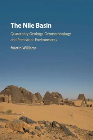
The Nile Basin
Quaternary Geology, Geomorphology and Prehistoric Environments
- Martin Williams(Author)
- 2019(Publication Date)
- Cambridge University Press(Publisher)
15 West of the Nile: The Western Desert of Egypt and the Eastern Sahara – Part 1 Level plains of smooth sand are interrupted only by occasional peaks of rock – black, stark, and shapeless. Rainless storms dance tirelessly over the hot, crisp surface of the ground. The fine sand, driven by the wind, gathers into deep drifts, and silts among the dark rocks of the hills, exactly as snow hangs about an Alpine summit; only it is a fiery snow, such as might fall in hell. Winston S. Churchill (1874–1965), The River War (1899) 15.1 Introduction The eastern Sahara is one of the driest and hottest regions on our planet. The Western Desert of Egypt is located west of the Nile within the hyperarid zone of the eastern Sahara (Fig. 15.1). This is an area with a notional mean annual precipitation of less than 5 mm and intervals of half a century or more with no recorded rainfall. Against this present-day background of extreme heat in summer and unremitting aridity, we are confronted with a paradox. Scattered across the eastern Sahara Desert there are abundant signs that this hyperarid region was once vegetated and capable of supporting a tropical savanna flora and fauna as well as occupation by successive prehistoric human groups from Lower Palaeolithic/Early Stone Age times onwards. How was it possible that the wilderness we see today was once a green and pleasant land capable of sustaining herds of domestic cattle as recently as 5,000 years ago? In addition to the present desert being clothed in trees, shrubs and grasslands at various times during the Quaternary, major rivers once flowed across the Sahara to the Mediterranean or to the Nile. The early to mid-Holocene lakes and once active but now ephemeral streams west of the Nile in northern Sudan and western Egypt became the locus of Mesolithic and Neolithic occupation and saw the progressive transition from hunter-fisher-gatherer economies to ones founded on animal and plant domestication.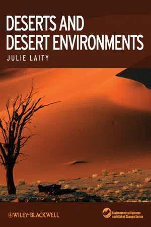 eBook - PDF
- Julie J Laity(Author)
- 2009(Publication Date)
- Wiley-Blackwell(Publisher)
Isolated deserts remain poorly described and under-stood, owing either to their inaccessibility or to polit-ical turmoil that precludes scientific study. The following descriptions of the world’s deserts summarize some of the essential characteristics of each region, including climate and climatic history, areal extent, vegetation, elevation, geology, and geo-morphology. More detailed information on other significant topics – for example, dust generation or specific landforms – is presented in the relevant chapters. 2.2 G LOBAL DESERTS 2.2.1 A FRICA The largest arid areas of Africa straddle the Tropics of Cancer (the Saharan Desert) and Capricorn (the Kalahari, Karoo, and Namib Deserts). The Somali-Chalbi Desert is found on the eastern horn of Africa. The southern sector of the island of Madagascar also has a warm semiarid climate. The largest area of hyperarid desert in the world (69%) is found in Africa, and collectively Africa is home to just over one-third of the Earth’s arid lands (United Nations Environment Program 1992). The great age of African arid regions is supported by the very high biodiver-sity of arid-adapted taxa. The plant and animal communities of Africa have evolved to reflect the considerable heterogeneity in climate and landscape. Many contemporary distribu-tion patterns are explained by plate-tectonic-driven shifts in the latitudinal position of the continent. The climatic history of Africa has fashioned the phyto-geographical, zoogeographical, and ecological char-acteristics of the deserts. A wide range of taxonomic groups has been fostered in this ancient continent, including the ancestors of modern humans. Vegeta-tion is a clue to a wide range of habitat factors and is an indication of dependent animal species. eBook - PDF
- Charles Fletcher, Dan Gibson, Kevin Ansdell(Authors)
- 2014(Publication Date)
- Wiley(Publisher)
The new settlement is distinguished by white plastic sheeting. These new arrivals add to the environmental burden on the surrounding desert environment. Identify some potential consequences of an influx of environmental refugees to a village already stressed by desertification. Expand Your Thinking—How would desertification in countries that border each other potentially lead to political strife? FIGURE 21.26 All six inhabited continents have significant areas that are threatened by desertification. 586 • CHAPTER 21 Desert and Wind deserts, poor land management (such as overgrazing) and changes in the water cycle due to global warming can permanently damage the native vegetation and soil. These factors lead to desertification. With human populations expanding worldwide, and global warming changing rainfall distribution, desertification is likely to be a problem that continues to grow in the future. Now that you have finished the chapter, “Geology in Our Lives” will have taken on new meaning for you. Let us review it: A desert is a landscape that receives little rainfall, has sparse vegetation, and is un- able to support significant populations of animals. Deserts are more widespread than you might think. In fact, they take up one-third of Earth’s land surface, and their range is growing. As human popula- tions swell and spread into marginally habitable areas bordering LET’S REVIEW “GEOLOGY IN OUR LIVES” STUDY GUIDE 21-1 Deserts may be hot or cold, but low precipitation is a common trait. • A desert is an arid region that receives less than 25 cm of pre- cipitation per year. Additionally, vegetation must be so sparse that the area is unable to support significant populations of animals. Slightly wetter regions, receiving between 25 cm and 51 cm of precipitation, are considered semi-arid. eBook - PDF
- Mateo Gutierrez(Author)
- 2012(Publication Date)
- CRC Press(Publisher)
These overlay geologic formations of different composition and ages in environ- ments of complete crustal stability or significant neotectonic activity. Desert climates are highly variable; they generally lack precipitation and have high temperatures with wide daily variations. Vegetation is scant or non-existent and plant met- abolic activity is adapted to the broad temperature variation. Plants obtain water from roots, which sometimes penetrate to a depth of 20 m (Nicholson, 1993). Plants that grow in arid zones, called xerophytes, have mechanisms that adapt to scarce water. In addition, desert environments are not favorable to man because of their extreme climates and the scarcity or absence of food and water. Human activity in these areas Figure 16.1 Region of pronounced aridity almost devoid of vegetation. Sinai Desert (Egypt) Photo J. Rosell. GEOMORPHOLOGY OF ARID ZONES I 617 also varies widely; some areas lack population and others are densely inhabited. Worldwide 15% of the population lives in desert regions (Heathcote, 1983). In addition, population is increasing in many arid areas; it has increased 50% or more in the last fifty years. Arid region population exceeded 1.2 bil- lion people by the year 2000. As a result of increasing popula- tion, human use of scarce water and plant resources creates numerous environmental problems that require difficult and costly solutions (Cooke et al., 1982; Goudie, 1990a). Arid regions have been defined in different ways depending on the purpose. Various criteria have been used to categorize arid regions; the most common distinctions are based on vegetation, drainage systems, soil degradation, and water and wind erosion. The most commonly used cri- terion is water availability because it affects flora and fauna and the dynamics of geomorphic processes. The water bal- ance defines water availability; in hot deserts evaporation and transpiration (ET) and surface and subterranean drain- age loss (D) exceed precipitation (P). eBook - PDF
Earth Science
An Introduction
- Mark Hendrix, Graham Thompson, Mark Hendrix(Authors)
- 2020(Publication Date)
- Cengage Learning EMEA(Publisher)
332 14 DESERTS AND WIND Wind erosion sculpted these bedrock spires in the Sahara Desert of Algeria, while wind deposition formed the sand dunes in the background and rippled sand in the lower left foreground. White-colored deposits of salt remain from a now-evaporated temporary lake to the right of the bedrock outcrop. PICHUGIN DMITRY/SHUTTERSTOCK.COM Copyright 2021 Cengage Learning. All Rights Reserved. May not be copied, scanned, or duplicated, in whole or in part. Due to electronic rights, some third party content may be suppressed from the eBook and/or eChapter(s). Editorial review has deemed that any suppressed content does not materially affect the overall learning experience. Cengage Learning reserves the right to remove additional content at any time if subsequent rights restrictions require it. Why Do Deserts Exist? 333 INTRODUCTION Earth’s continents are classified into climate zones based primarily on precipitation and temperature. In turn, climate determines the communities of plants and animals that live in a region. A desert is any region that receives less than 25 centimeters (10 inches) of rain per year and consequently supports little or no vegetation. 1 Most deserts are surrounded by semiarid zones that receive 25 to 50 centimeters of annual rainfall—more moisture than a true desert but less than adjacent regions. Deserts cover 25 percent of Earth’s land surface outside of the polar regions and make up a significant part of every continent. If you were to visit the great deserts of Earth, you might be surprised by their geologic and topographic variety. You would see coastal deserts along the beaches of Chile; shifting dunes in the Sahara; deep, red sandstone canyons in southern Utah; stark granite mountains in Arizona; and bitter-cold polar deserts with a few lichens clinging tenaciously to the otherwise barren rock. The world’s deserts are similar only in that they all receive scant rainfall. eBook - PDF
Design with the Desert
Conservation and Sustainable Development
- Richard Malloy, John Brock, Anthony Floyd, Margaret Livingston, Robert H. Webb(Authors)
- 2016(Publication Date)
- CRC Press(Publisher)
3 1 Deserts of the World* Ron Cooke, Andrew Warren, and Andrew Goudie 1.1 Introduction To some, deserts are simply barren areas, barely capable of supporting life forms. Many places meet this criterion: Mangin’s The Desert World , published in 1869, 1 embraced envi-ronments as diverse as the waste heaps of the china clay quarries in Cornwall, the steppes of Tartary, the Dead Sea, and the Arctic wildernesses. But most deserts are areas of arid-ity and they are usually defined scientifically in terms of some measure of water short-age. Such measures, indices of aridity, are commonly based on the relationships between water gained from precipitation and water lost by evaporation or transportation. There are plenty of indices to choose from, the differences between them reflecting different objec-tives of classification. 2 The areas shown in Figure 1.1 constitute the warm deserts realm. Within it, there are five major regions of aridity: the deserts of North and South America, North Africa, Eurasia, southern Africa, and Australia. They cover a third of the Earth’s land surface and are the context for this study of desert geomorphology. † There are also arid areas in the polar * Adapted from R. Cooke, A. Warren, and A. Goudie, Deserts of the world, in Desert Geomorphology (London, U.K.: University of London Press, 1993), pp. 423–447. † Definitions used in footnotes in this chapter are derived from the combination of W. R. Osterkamp and A. Allaby and M. Allaby. 3 CONTENTS 1.1 Introduction ............................................................................................................................ 3 1.2 The Sahara and Its Margins ................................................................................................. 4 1.3 Southern Africa ...................................................................................................................... eBook - PDF
Geology
Earth in Perspective
- Reed Wicander, James Monroe, Reed Wicander(Authors)
- 2019(Publication Date)
- Cengage Learning EMEA(Publisher)
Arid regions, generally described as deserts, are dry and receive less than 25 cm of rain per year. The majority of the world’s deserts are located in the dry climates of the low and middle latitudes. ● FIGURE 14.14 The General Circulation Pattern of Earth’s Atmosphere Air flows from high-pressure zones to low- pressure zones, and the resulting winds are deflected to the right of their direction of movement (clockwise) in the Northern Hemisphere, and to the left of their direction of movement (counterclockwise) in the Southern Hemisphere. This deflection of air between latitudinal zones resulting from Earth’s rotation is known as the Coriolis effect. Copyright 2021 Cengage Learning. All Rights Reserved. May not be copied, scanned, or duplicated, in whole or in part. Due to electronic rights, some third party content may be suppressed from the eBook and/or eChapter(s). Editorial review has deemed that any suppressed content does not materially affect the overall learning experience. Cengage Learning reserves the right to remove additional content at any time if subsequent rights restrictions require it. Characteristics of Deserts 297 it cools, forming clouds and producing precipitation that falls on the windward side of the mountains. The air that descends on the leeward side of the mountain range is much warmer and drier, producing a rain-shadow desert. CHARACTERISTICS OF DESERTS LO11 Describe the temperature ranges, amount of precip- itation, and features of vegetation found in deserts LO12 Discuss which of the two types of weathering is dominant in deserts and how this relates to the type of soil formed LO13 Describe the type of mass wasting that takes place in deserts LO14 Describe the type of drainage found in deserts LO15 Explain how wind is an effective geologic agent in deserts To people who live in humid regions, deserts may seem stark and inhospitable. eBook - PDF
Physical Geology
The Science of Earth
- Charles Fletcher(Author)
- 2017(Publication Date)
- Wiley(Publisher)
The Sahel is not the only region threatened by desertifica- tion. Every continent on Earth has large areas suffering due to this hazardous process. But the experiences in the Sahel can serve as a mirror of the strife that is emerging in. Study Guide 611 Study Guide 19.1 Deserts may be hot or cold, but low precipitation is a common trait • A desert is an arid region that receives less than 25 centimeters of precipitation per year, and where vegetation is so sparse that the area is unable to support significant populations of animals. Slightly wetter regions, receiving between 25 and 51 centimeters of precipitation, are considered semiarid. • Expanding deserts, a process known as desertification, alter the distribution of natural resources (especially water), which can lead to political unrest when one group of people appropriates the resources of another, or migrates into new, resource-rich lands. • Deserts experience a wide daily and seasonal temperature range. High daytime temperatures (up to 45°C), followed by low nighttime temperatures (down to 0°C), are the result of the low humidity. 19.2 Atmospheric moisture circulation determines the location of most deserts • Global atmospheric circulation creates the general characteris- tics of weather everywhere. The basic components of the system are the Hadley cell, the Ferrel cell, and the Polar cell. There is one of each cell type in the northern hemisphere and one of each cell type in the southern hemisphere. • Air warms and contracts as it sinks closer to Earth’s surface. This causes evaporation to exceed condensation. No clouds will form in locations with a lot of sinking air. These areas, such as at the poles and 30° latitude, will have few clouds and little precipi- tation, thus forming a great belt of deserts that girdles the globe. Many of the world’s deserts are clustered around 30° N and 30° S latitudes for this reason. eBook - PDF
The Changing Earth
Exploring Geology and Evolution
- James Monroe, Reed Wicander(Authors)
- 2014(Publication Date)
- Cengage Learning EMEA(Publisher)
Once the fragile soil cover has been removed by erosion, it takes centuries for new soil to form (see Chapter 6). There are many important reasons to study deserts and the processes that are responsible for their formation. First, deserts cover large regions of Earth’s surface. More than 40% of Australia is desert, and the Sahara occupies a vast part of northern Africa. Addi-tionally, many desert regions are experiencing increases in population growth, such as the high desert area of southern California and parts of Nevada, as well as various locations in Arizona. Many of these places already have problems associated with increasing population and the strains it places on the environment, particularly the need for great amounts of groundwater. Furthermore, with the current debate about global warming, it is important to understand how desert processes operate and how global climate changes affect the various Earth systems and subsystems. Learning about the under-lying causes of climate change by examining ancient desert regions may provide insight into the possible duration and severity of future climatic changes. As an example, more than 6,000 years ago, the Sahara was a fertile savannah supporting a diverse fauna and flora, including humans. Then the climate changed, and the area became a desert. How did this happen? Will this region change back again in the future? These are some of the ques-tions geoscientists hope to answer by studying deserts. By understanding the underlying causes of desertification, it might be possible to implement steps to reduce the destruc-tion done by desertification, particularly in terms of human suffering. 15.2 Sediment Transport by Wind Wind is a turbulent fluid and therefore transports sediment in much the same way as running water. Although wind typically flows at a greater velocity than water, it has a lower density and thus can carry only clay- and silt-size particles as suspended load . eBook - PDF
Arid Lands
Today And Tomorrow
- Charles Hutchinson(Author)
- 2019(Publication Date)
- Routledge(Publisher)
However, the basic methodology was modified to account for the local intermediate situation in which the extensive but recent land use is not imprinted in the landscape. As a consequence of shifting agriculture, natural vegetation remnants are almost absent. Ten ecosystems were identified on the continental dry region through the delimitation of climax complexes. These land units are described on the basis of geology, landform, topography, soil, vegetation, climate and land use. Degree of plant cover and inherent vulnerability are related to livelihood system and desertification hazard. These units show enough coherence to be the basis for agroecosystems delimitation. INTRODUCTION The dry zone of Falcon State, which forms part of the Caribbean Dry Region, lies on the western coast and stretches to the south up to the 400-meter contour line and into the central depression on the lee side of the ridges. According to Bailey's moisture index it falls within the arid and semiarid provinces. It is characterized by low rainfall (142 to 688 millimeters) concentrated in one or two short rainy seasons, high evaporative demand (3,100 to 3,500 millimeters) and uniform warm temperatures (29°C) prevailing throughout the year, though day-night temperature differences can reach up to 10°C. At this latitude, in such a marine location, abundant precipitation would be expected. The possible cause of this anomaly is explained by Lahey ( 1). In the Cretaceous, the study area was occupied by a geosynclinal belt stretching in an ENE-WSW direction, covered by a continental sea. Several episodes of continental and marine deposition produced interbedded shales and sandstones, with layers of conglomerate and limestone. Orogenetic activity started in the Lower Miocene, with the uplifting and tilting of the Coastal Piedmont, and ended in the Pliocene.
Index pages curate the most relevant extracts from our library of academic textbooks. They’ve been created using an in-house natural language model (NLM), each adding context and meaning to key research topics.