This book is a comprehensive overview of the ever-captivating field of glaciation from the perspective of glacial landsystems. This approach models the many processes, forms and interactions that can be found in glaciated landscapes throughout the world. Landsystems models allow the glacial geologist and geomorphologist to evaluate these landscapes in relation to the dynamics of glaciation and to climate and geology. Glacial Landsystems brings together the expertise of an international range of specialists to provide an up-to-date summary of landsystems relevant to both modern and ancient glacier systems and also in the reconstruction and interpretation of former glacial environments. The models are applicable at all scales from ice sheets to small valley glaciers.This book is an essential reference for anyone embarking upon research or engineering surveys in glaciated basins and provides a wide-ranging handbook of glacial landsystem types for students of glaciation.
- 544 pages
- English
- ePUB (mobile friendly)
- Available on iOS & Android
eBook - ePub
GLACIAL LANDSYSTEMS
About this book
Trusted by 375,005 students
Access to over 1.5 million titles for a fair monthly price.
Study more efficiently using our study tools.
Information
CHAPTER
1
INTRODUCTION TO GLACIAL LANDSYSTEMS
1.1 LANDSYSTEMS
The landsystems concept was initially popularized in the reports of the Commonwealth Scientific and Industrial Research Organization for the mapping of large, sparsely populated areas in Australia in the 1940s (e.g. Christian and Stewart, 1952). Following the pioneering work of Bourne (1931), Unstead (1933) and Veatch (1933), these surveys were stimulated by the desire to evaluate the agricultural potential of large expanses of land. They sought to classify land based upon a landsystems approach, which recognized a landsystem as an area with common terrain attributes, different to those of adjacent areas. The areal coverage of a landsystem was therefore dictated by the size of the terrain attributes and could range from tens to hundreds of kms2. A recurring pattern of topography, soils and vegetation was regarded as characterizing a landsystem. Theoretically, each landsystem should contain a predictable combination of surface features (landforms) and associated soils and vegetation types. During the preliminary stages of mapping, the topography and/or geomorphology is usually the most significant criterion employed in differentiating landsystems.
A landsystem is divided into smaller components called units (or facets) and elements (Lawrance, 1972). In early reports the land units were often depicted in three-dimensional sketches from which immediate impressions could be gained of relative relief and patterns and densities of land elements. Aerial photograph stereopairs were also used to exemplify typical units of the landsystem. The developmental history of landsystems mapping, as it pertains to terrain classification, is reviewed in more detail by Mabbutt (1968), Mitchell (1973), Ollier (1977), King (1987), and Cooke and Doornkamp (1990). Applications of the landsystems concept to assessments of glaciated terrain have been less of a quantitative mapping exercise for regional development purposes and more for landscape characterization, useful for reconstruction of palaeo-glaciation and predicting the presence of specific sediments. Moreover, because glaciated terrains are often blanketed with depositional features, glacial geomorphologists and geologists have emphasized the properties, structures and distributions of materials that lie beneath the surface in their landsystems models (Eyles, 1983a). This allows the landsystems approach to be employed as a holistic form of terrain evaluation, by not only linking the geomorphology and subsurface materials in a landscape, but genetically relating them through process-landform studies. Moreover, it provides a powerful tool for the reconstruction and interpretation of former glacial environments and ice dynamics.
1.2 GLACIAL LANDSYSTEMS
Mapping in glaciated terrains traditionally involved the grouping of landforms according to common origin and age. An excellent early example of this approach is that of Speight (1963) in the Lake Pukaki area of South Island, New Zealand. Suites of glacial features grouped as ‘landform associations’ essentially constituted inset sequences of glaciated valley landsystems (see below). The linking of process and form over a large area of diverse glacial landforms was pioneered by Clayton and Moran (1974) in their assessment of the spatial distribution of glacial features in North Dakota, USA (Fig. 1.1). They reconstructed changes in ice dynamics during a cycle of glacial advance and recession, emphasizing both spatial and temporal landform-sediment assemblages and recognizing that glacial features can be added to a landscape as a series of layers (stratigraphy). Important advances represented by this work included the focus on glacial stratigraphy as a prerequisite to studying glacial geomorphology, the commitment to assessing groups of landforms rather than individual forms in isolation, and the recognition of process continuums. This approach, therefore, acknowledged the complexity of glacial depositional systems and highlighted the superimposition of landform-sediment assemblages (‘preadvance, subglacial, superglacial and postglacial elements’) in spatially coherent ‘suites’ (Fig. 1.1).
Glacial landsystems were first compiled by Fookes et al. (1978) to provide engineers with process-form classifications of glacigenic landform-sediment assemblages. In order to simplify the predominantly complex sequences of landforms and sediments in glaciated basins, three landsystems were identified. The first was the ‘till plain landsystem’ which encompassed subglacially deposited tills and drumlinized surfaces. Second, the ‘glaciated valley landsystem’ referred to the materials produced by melting glacier ice (e.g. end, lateral and medial moraines) but excluded glacifluvial sediments. Finally, the ‘fluvioglacial and ice-contact deposit landsystem’ included all those landforms and sediments that are of ice-contact glacifluvial origin. These landsystems are differentiated not only by the landform-sediment assemblages that they contained but, more specifically and also on a practical level, by the engineering properties of their component materials. The Fookes et al. (1978) landform-sediment assemblages are, therefore, directly comparable with the ‘elements’ of Clayton and Moran (1974).
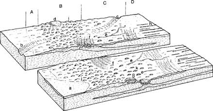
Figure 1.1 A process-form model for the glacial features of North Dakota, emphasizing the zonal nature of particular glacial landform assemblages. A = fringe suite, B = marginal suite, C = transitional suite, D = inner suite; a = fluvial plain, b = meltwater channel, c = partly buried meltwater channel, d = ice-walled lake plain, e = eskers, f = transverse compressional features, g = thrust mass, h = longitudinal features/flutings, i = recessional push moraines, j = hummocks, k = disintegration ridges. (After Clayton and Moran, 1974.)
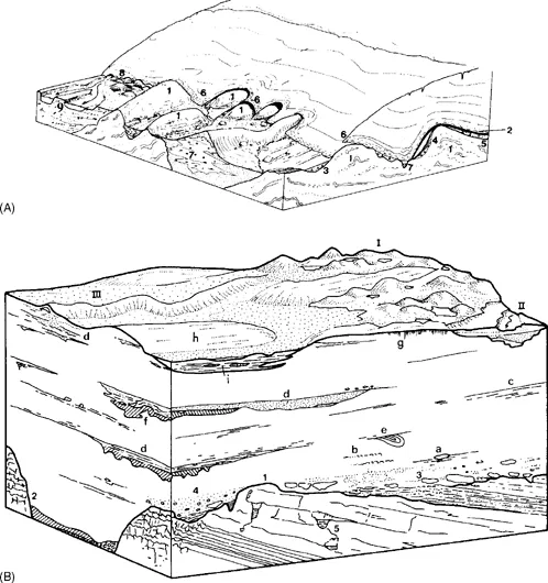
Figure 1.2 The subglacial landsystem. A) An area with hard substrate: 1 = rock drumlins, 2 = basal debris, 3 = subglacial lodgement/deformation till, 4 = lee-side cavity fill, 5 = basal till, 6 = supraglacial debris, 7 = esker, 8 = kettled outwash, 9 = proglacial sandur. B) An area of limestone substrate covered by stacked tills: I = hummocky kame and kettle topography, II = terraced outwash incised into subglacial sediments, III = esker, a = aligned faceted clasts, b = shear lamination, c = slickensided bedding planes, d = stratified subglacial cavity or canal fills, e = folded and sheared-off channel fill, f = diapiric till intrusion into cavity fill, g = vertical joints produced by pedogenesis, h = drumlin, i = interdrumlin depression filled with postglacial sediment, 1 = striated rock head, 2 = buried channel or valley, 3 = glacitectonized rock head producing rock rafts and boulder pavements in till, 4 = lowermost till with local lithologies, 5 = cold water karst. (From Eyles, 1983a).
The component parts of landsystems, the elements and units, were placed in the context of glaciated basins by Fookes et al. (1978) and subsequently by Eyles (1983a). Elements are simply individual landforms that can be mapped at large scales. This includes features like drumlins, flutings, eskers, kame terraces and moraines. Such features can then be grouped as units, which constitute relatively homogeneous tracts of land that are distinct from surrounding surfaces. A typical land unit may comprise a drumlin or fluting field, an area of Rogen moraine, a suite of recessional push moraines or an outwash plain. The landsystem is a recurrent pattern of genetically linked land units. Eyles (1983a, b), Eyles and Menzies (1983) and Paul (1983) deviated from the initial landsystems classifications of Fookes et al. (1978) by incorporating all of the landform and sediment types associated with particular glaciation styles. For example, the subglacial landsystem included subglacial tills and streamlined landforms in association with glacifluvial features like eskers (Fig. 1.2). Similarly, the supraglacial landsystem contained stratified glacifluvial sediment accumulations associated with ice stagnation in addition to chaotic hummocky moraine (Fig. 1.3). The glaciated valley landsystem was re-packaged by Eyles (1983b) to include all of the landforms and sediments produced by the glaciation of mountain valleys and was not restricted to supraglacial features (Fig. 1.4). Glaciated terrain was then mapped according to the dominant landsystems (Eyles and Dearman, 1981; Eyles et al., 1983a), providing a predictive tool for rapid assessments of subsurface materials by those involved in resource and engineering project management.
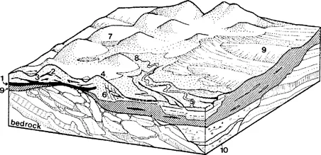
Figure 1.3 The supraglacial landsystem. 1 = melt-out till, 2 and 3 = flowed supraglacial diamictons, 4 = hummocky terrain composed of kames and chaotic hummocky moraine, 5 = terraced glacifluvial sediments, 6 = failure of strata by normal faulting due to the melting of adjacent ice cores, 7 = kettle holes and small ponds located between hummocks, 8 = outwash fan fed by melting ice cores in hummocky terrain, 9 = drumlinized subglacial till surface visible through a window in the supraglacial landsystem, 10 = buried valley or infilled tunnel valley. (After Eyles, 1983a).
Since the introduction of these primary glacial landsystems, intensive research around modern glacier margins has led to an expansion of the landsystem concept. Brodzikowski and van Loon (1987, 1991) maintained the separation of landform-sediment assemblages according to environment of deposition (Fig. 1.5), preferring not to emphasize the influence of glacier morphology and dynamics. However, glacial depositional environments are extremely complex, and variability in landform-sediment assemblages is dictated not only by the location of deposition but also by the ‘style’ of glaciation. Glaciation ‘styles’ are a function of climate, basement and surficial geology and topography, and consequently a wide range of glacial landsystems have been compiled for different ice masses and dynamics (Benn and Evans, 1998, chapter 12). For example, it has been recognized that the details of glaciated valley landsystems will reflect the relative relief and climatic regime of mountain...
Table of contents
- Cover
- Title Page
- Copyright Page
- Table of Contents
- Preface
- List of Contributors
- Acknowledgements
- Chapter 1 Introduction to glacial landsystems
- Chapter 2 Ice-Marginal Terrestrial Landsystems: Active Temperate Glacier Margins
- Chapter 3 Ice-Marginal Terrestrial Landsystems: Sub-Polar Glacier Margins of the Canadian and Greenland High Arctic
- Chapter 4 Ice-Marginal Terrestrial Landsystems: Svalbard Polythermal Glaciers
- Chapter 5 Ice-Marginal Terrestrial Landsystems: Polar-Continental Glacier Margins
- Chapter 6 Ice-Marginal Terrestrial Landsystems: Southern Laurentide Ice Sheet Margin
- Chapter 7 Ice-Marginal Terrestrial Landsystems: Northern Laurentide and Innuitian Ice Sheet Margins
- Chapter 8 Ice-Marginal Terrestrial Landsystems: Southern Scandinavian Ice Sheet Margin
- Chapter 9 Palaeo-Ice Stream Landsystem
- Chapter 10 Supraglacial Landsystems in Lowland Terrain
- Chapter 11 Surging Glacier Landsystem
- Chapter 12 Subaquatic Landsystems: Continental Margins
- Chapter 13 Subaquatic Landsystems: Fjords
- Chapter 14 Subaquatic Landsystems: Large Proglacial Lakes
- Chapter 15 Glaciated Valley Landsystems
- Chapter 16 Plateau Icefield Landsystems
- Chapter 17 Paraglacial Landsystems
- References
- Index
Frequently asked questions
Yes, you can cancel anytime from the Subscription tab in your account settings on the Perlego website. Your subscription will stay active until the end of your current billing period. Learn how to cancel your subscription
No, books cannot be downloaded as external files, such as PDFs, for use outside of Perlego. However, you can download books within the Perlego app for offline reading on mobile or tablet. Learn how to download books offline
Perlego offers two plans: Essential and Complete
- Essential is ideal for learners and professionals who enjoy exploring a wide range of subjects. Access the Essential Library with 800,000+ trusted titles and best-sellers across business, personal growth, and the humanities. Includes unlimited reading time and Standard Read Aloud voice.
- Complete: Perfect for advanced learners and researchers needing full, unrestricted access. Unlock 1.5M+ books across hundreds of subjects, including academic and specialized titles. The Complete Plan also includes advanced features like Premium Read Aloud and Research Assistant.
We are an online textbook subscription service, where you can get access to an entire online library for less than the price of a single book per month. With over 1.5 million books across 990+ topics, we’ve got you covered! Learn about our mission
Look out for the read-aloud symbol on your next book to see if you can listen to it. The read-aloud tool reads text aloud for you, highlighting the text as it is being read. You can pause it, speed it up and slow it down. Learn more about Read Aloud
Yes! You can use the Perlego app on both iOS and Android devices to read anytime, anywhere — even offline. Perfect for commutes or when you’re on the go.
Please note we cannot support devices running on iOS 13 and Android 7 or earlier. Learn more about using the app
Please note we cannot support devices running on iOS 13 and Android 7 or earlier. Learn more about using the app
Yes, you can access GLACIAL LANDSYSTEMS by David Evans, Liz Gooster in PDF and/or ePUB format, as well as other popular books in Physical Sciences & Human Geography. We have over 1.5 million books available in our catalogue for you to explore.